Bula (river)
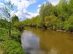
The Bula (Russian: Була; Chuvash: Пăла, Păla; Tatar: Бола) is a river in the Chuvash Republic and the Republic of Tatarstan, Russia, a left-bank tributary of the Sviyaga. Its length is 118 kilometres (73 mi) and its drainage basin is 1,580 square kilometres (610 sq mi).[1] It originates in the Chuvash Republic and falls into the Sviyaga River south of Devlikeyevo.
| Bula | |
|---|---|
 | |
| Location | |
| Country | The Chuvash Republic and Tatarstan, Russia |
| Physical characteristics | |
| Source | |
| • location | Lipovka, Ibresinsky District, Chuvash Republic |
| Mouth | Sviyaga |
• location | near Devlikeyevo, Apastovsky District, Tatarstan |
• coordinates | 55°12′19″N 48°23′10″E |
| Length | 118 km (73 mi) |
| Basin size | 1,580 km2 (610 sq mi) |
| Discharge | |
| • average | 490 m3/s (17,000 cu ft/s) (max, 1979, near Chatbash) |
| Basin features | |
| Progression | Sviyaga→ Volga→ Caspian Sea |
Major tributaries are the Cheremshan and the Malaya Bula. The maximum mineralization is 700–1000 mg/L.[2] Batyrevo, the administrative center of Batyrevsky District of the Chuvash Republic, is located on the river.
References
- «Река Була», Russian State Water Registry
- "Бола". Tatar Encyclopaedia (in Tatar). Kazan: The Republic of Tatarstan Academy of Sciences. Institution of the Tatar Encyclopaedia. 2002.
This article is issued from Wikipedia. The text is licensed under Creative Commons - Attribution - Sharealike. Additional terms may apply for the media files.