Pocono Formation
The Mississippian Pocono Formation is a mapped bedrock unit in Pennsylvania, Maryland, and West Virginia, in the United States. It is also known as the Pocono Group in Maryland and West Virginia,[2] and the upper part of the Pocono Formation is sometimes called the Burgoon Formation or Burgoon Sandstone in Pennsylvania.[3][4] The Pocono is a major ridge-former In the Ridge-and-Valley Appalachians of the eastern United States[5]
| Pocono Formation | |
|---|---|
| Stratigraphic range: Early Mississippian | |
 Outcrop at Ricketts Glen State Park | |
| Type | sedimentary |
| Underlies | Mauch Chunk Formation |
| Overlies | Catskill Formation, Huntley Mountain Formation, Rockwell Formation, and Spechty Kopf Formation |
| Lithology | |
| Primary | Quartzarenite (sandstone) |
| Other | Conglomerate |
| Location | |
| Region | Appalachian Mountains |
| Extent | Pennsylvania and Virginia[1] |
| Type section | |
| Named by | Lesley, 1876 |
The Pocono is also a lateral equivalent of the Purslane Sandstone in Maryland and West Virginia. D. Brezinski of Maryland Geological Survey recommended abandoning use of the term Pocono in Maryland in favor of "Purslane" in 1989.[6]
Description
The Pocono is a dominantly gray color with quartzitic medium to coarse-grained sandstones. The base of the Pocono Formation is marked by conglomerate.[7]

Notable exposures
- The type section of the Burgoon Sandstone is in the valley of Burgoon Run, above Kittanning Point, Blair County, Pennsylvania.
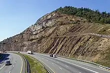
- A spectacular exposure of the Purslane Sandstone (equivalent to the Pocono) is at the I-68 road cut through Sideling Hill in Maryland.
Age
Relative age dating of the Pocono places it in the lower Mississippian period. The lower boundary is with the Spetchy Kopf Formation and Huntley Mountain Formation. In South-central Pennsylvania, the Pocono often interfingers with the Rockwell Formation.[8]
References
- Paleozoic Sedimentary Successions of the Virginia Valley & Ridge and Plateau
- Geologic Maps of Maryland:
- Van Diver, Bradford B. (1990). Roadside Geology of Pennsylvania. Missoula, Montana: Mountain Press Publishing Company. p. 83. ISBN 0-87842-227-7.
- "Burgoon Sandstone". United States Geological Survey. May 22, 2009. Retrieved June 8, 2009.
- Kempler, Steve (2007-01-19). "Geomorphology : Chapter 2 Plate T-12 : Folded Appalachians". NASA, Goddard Earth Sciences (GES), Data and Information Services Center (DISC). Archived from the original on 2007-12-06. Retrieved 2008-03-16.
The major ridge makers are the Tuscarora (T), Pocono (Po), and Pottsville (Pt) Formations.
- Brezinski, D.K., 1989, The Mississippian System in Maryland: Maryland Geological Survey Report of Investigations, no. 52, 75 p.
- "Geology : Pocono (Mp)". LEO EnviroSci Inquiry. Lehigh University. Archived from the original on 2007-07-12. Retrieved 2008-03-16.
- Berg, T.M., Edmunds, W.E., Geyer, A.R. and others, compilers, (1980). Geologic Map of Pennsylvania: Pennsylvania Geologic Survey, Map 1, scale 1:250,000.