Butaro Hospital
The Butaro Hospital (Kinyarwanda: Ibitaro bya Butaro) is a hospital in Burera District, in the Northern Province of Rwanda.[1] The hospital serves as the district hospital for Burera District and surrounding communities.[2]
| Butaro Hospital | |
|---|---|
 | |
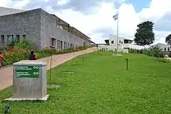
 Butaro Hospital, October 2011 | |
| Geography | |
| Location | Butaro Sector, Burera District, Northern Province, Rwanda |
| Organisation | |
| Funding | Public hospital |
| Services | |
| Emergency department | Yes |
| Beds | 150 |
| History | |
| Opened | 24 January 2011 |
| Links | |
| Lists | Hospitals in Rwanda |

Location
Butaro District Hospital is located in the Butaro Sector, of Burera District, in Rwanda's Northern Province, approximately 96 kilometres (60 mi), by road, north of Kigali, the national capital of Rwanda, and its largest city.[3] The geographical coordinates of the hospital are 01°24'35.0"S, 29°50'24.0"E (Latitude:-1.409722; Longitude:29.840000).[2]
Overview
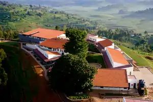
Butaro Hospital maintains 256 in-patient beds.[4] The facility features an innovative design intended to harmonize with the local environment and reduce the risk of hospital-acquired infections. Hospital departments include emergency room, intensive care units, pediatric ward, surgical theaters and an IT room. The hospital is equipped with Wireless Internet throughout the hospital campus, with laptop computers present at every nursing station. Telemedicine facilities are available for consultation with Harvard Medical School and Brigham and Women’s Hospital.[1]
History
The Butaro Hospital was designed by MASS in cooperation with the Rwandan Ministry of Health and Partners in Health. The construction of the 150-bed hospital begun in December 2008 and it was opened on 24 January 2011. The hospital was originally a health center, prior to 2008. Commissioning of the completed hospital was performed by Paul Kagame, the President of Rwanda.[5]
Construction was completed one year earlier than scheduled. Over 3,500 local community members were employed during construction. Wherever possible, the hospital was built using local materials, including volcanic stone from the Virunga Mountains.[1]
Butaro Cancer Center of Excellence
In July 2012, Butaro Cancer Center of Excellence opened its doors to the public, offering the first cancer ward in rural East Africa. It was developed by Partners In Health, with support from Dana-Farber Cancer Institute and the Rwandan government. The Jeff Gordon Children’s Foundation contributed $1.5 million to its creation.[6]
Butaro Ambulatory Cancer Center
In 2013, an outpatient facility was added to treat cancer patients who need regular IV chemotherapy, but who do not require hospitalization. Services include pathology-based diagnosis, chemotherapy, and surgery, referral for radiotherapy, socio-economic support, and long-term follow up.[7]
Butaro Ambulatory Cancer Center was designed by MASS Design Group, built by Partners In Health, and funded by the Cummings Foundation, Inc. of Woburn, Massachusetts. Other partners include the government of Rwanda, Rwanda Biomedical Center, and Dana-Farber/Brigham and Women's Hospital Cancer Center in Boston.[7]
References
- PIH (25 January 2011). "Rwanda's Butaro Hospital Opens its Doors". Boston: Partners In Health (PIH). Retrieved 4 April 2019.
- Google (4 April 2019). "Location of Burera District Hospital" (Map). Google Maps. Google. Retrieved 4 April 2019.
- Globefeed.com (4 April 2019). "Distance between Central Kigali, Rwanda and Butaro District Hospital, Rwanda". Globefeed.com. Retrieved 4 April 2019.
- "https://twitter.com/RwandaHealth/status/1709219671163941063?s=20". X (formerly Twitter). Retrieved 3 October 2023.
{{cite web}}: External link in|title= - Partners In Health (2018). "Butaro Hospital". Boston: Partners In Health. Retrieved 4 April 2019.
- Shen, Helen (18 July 2012). "A Boost From Boston In Rwanda's Cancer Fight". The Boston Globe. Retrieved 4 April 2019.
- Jeff Marvin (21 August 2013). "PIH/IMB and the Rwandan Ministry of Health Celebrate the Opening of the Butaro Ambulatory Cancer Center". Boston: Partners In Health. Retrieved 4 April 2019.