Cacavei
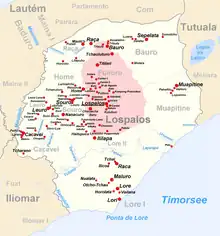
Cacavei is a village (suco) in East Timor. It is located in Lospalos sub-district and Lautem district. This village is in between Lospalos town and Iliomar sub-district.

Data
Surface 50.50 km ² [1] Population 864 (2.01 thousand) [1] Chefe de Suco José Marques (2009 election) Places Position [2] Height Cacavei ♁ 8 ° 34 ' S, 126 ° 53 ' O 303 m Choquiro ♁ 8 ° 34 ' S, 126 ° 55 ' O 252 m Laiara ♁ 8 ° 34 ' S, 126 ° 53 ' O 303 m Maluro ♁ 8 ° 34 ' S, 126 ° 53 ' O 313 m Paihira ♁ 8 ° 34 ' S, 126 ° 53 ' O [4] 303 m Tcharano ♁ 8 ° 36 ' S, 126 ° 53 ' O 285 m Vatalara ♁ 8 ° 34 ' S, 126 ° 54 ' O 261 m Cacavei (East Timor) Cacavei ( Cacaven, Cacavem, Kakavei, Kakaven, Cacuvem ) is an osttimoresisches village in Suco Cacavei (subdistrict Lospalos, District loud ).
The place
The village Cacavei is in the northwest of the Sucos at an altitude of 303 m. In the immediate vicinity of the settlements are Cacavei Laiara, Maluro and Paihira . The village center has a primary school and a health center.[3]
Cacavei has 864 inhabitants (2010[3] 2004: 879 [4]). Almost 95% of the population speaks Fataluku as their native language. Other languages include Sa'ane, Makasae, Tetum Prasa, Tetum Terik and Makalero.[5]
Location
The village is located the west part of the sub-district Lospalos and has an area size of 50.50 km ².[6] To the north it borders Suco Leuro and on the northeast the Suco Souro. To the southeast is Suco Lore I.
To the southwest lies the subdistrict Iliomar with the village Fuat and to the northwest the Suco Maina II. Across the village is the Paunara river which flows from north to south. Its sources is in the Suco Souro. From the west, here ends the originating within Cacavei flow Ainarauteu. At the southern boundary of the Paunara river it travels to the southeast and represents the border to Suco Fuat. After hitting the Pirusoro on the border river from Fuat, it changes its name to Namaluto. The southern part of the border between Cacavei and Souro forms the river Vahurau. Once the border of Lore I reaches it, it opens into the river Tchino, which then flows along the border to the west and finally empties into the Namaluto.
East of the Cacavei's village center are Choquiro and Vatalara, south of the city Tcharano (Charano). The places are above the provincial road linking the capital district Lospalos with the district Iliomar. East of Paunara there are no more major settlements.[7]
In Cacavei are the four aldeias Laiara, Paihara, Sole Para and Tcharano.[8]
Politics
In the elections of 2004/2005 José Marques was elected Chefe de Suco.[9] In the 2009 elections José Marques won again.[10]
See also
- Ulurapa, a mountain in the village
References
- Direcção Nacional de Estatística: Suco Report Volume 4 (English) (PDF, 9.8 MB)
- fallingrain.com: Directory of Cities, Towns, and Regions in East Timor
- UNMIT: Timor-Leste District Atlas version02, August 2008 (PDF, 389 kB)
- Direcção Nacional de Estatística Census 2004
- results of the census 2010 for the village Cacavei ( Tetum , PDF, 8.6 MB)
- Direcção Nacional de Estatística: Population Distribution by Administrative Areas Volume 2 English (Census 2010; PDF; 22.6 MB)
- Timor-Leste GIS Portal
- Jornal da República with the Ministerial Diploma n ° 199/09 (Portuguese, PDF, 323 kB)
- Secretariado Técnico de Administração Eleitoral STAE: Eleições para liderança Comunitária 2004/2005 - Resultados
- Secretariado Técnico de Administração Eleitoral STAE: Eleições para liderança Comunitária 2009 - Resultados
External links
- Results of the census 2010 for the Suco Cacavei ( Tetum, PDF, 8.6 MB)