Shire of Campaspe
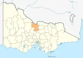
The Shire of Campaspe is a local government area in Victoria, Australia, located in the northern part of the state. It covers an area of 4,519 square kilometres (1,745 sq mi) and in August 2021 had a population of 38,735.[3]
| Shire of Campaspe Victoria | |||||||||||||||
|---|---|---|---|---|---|---|---|---|---|---|---|---|---|---|---|
 Location in Victoria | |||||||||||||||
| Population | 38,735 (2021)[1] | ||||||||||||||
| • Density | 8.5716/km2 (22.2003/sq mi) | ||||||||||||||
| Established | 1994 | ||||||||||||||
| Gazetted | 20 January 1995[2] | ||||||||||||||
| Area | 4,519 km2 (1,744.8 sq mi)[3] | ||||||||||||||
| Mayor | Cr Adrian Weston | ||||||||||||||
| Council seat | Echuca | ||||||||||||||
| Region | Loddon Mallee | ||||||||||||||
| State electorate(s) | |||||||||||||||
| Federal division(s) | Nicholls | ||||||||||||||
| Website | Shire of Campaspe | ||||||||||||||
| |||||||||||||||
It includes the towns of Girgarre, Echuca, Kyabram, Rochester, Tongala and Rushworth. It was formed in 1995 from the amalgamation of the City of Echuca, Shire of Deakin, Shire of Rochester, Shire of Waranga, Town of Kyabram and part of the Shire of Rodney.[2][4]
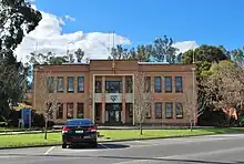
The Shire is governed and administered by the Campaspe Shire Council; its seat of local government and administrative centre is located at the council headquarters in Echuca, it also has service centres located in Kyabram, Rochester, Rushworth and Tongala. The Shire is named after the Campaspe River, a major geographical feature that meanders through the LGA.
Council
Current composition
The council is composed of five wards and nine councillors, with three councillors per ward elected to represent each of the Echuca and Kyabram-Deakin wards, and one councillor per remaining ward elected to represent each of the other wards.[5]
| Ward | Councillor | Notes | |
|---|---|---|---|
| Echuca | Tony Marwood | ||
| Robert Amos | |||
| Christine Weller | |||
| Kyabram-Deakin | Colleen Gates | ||
| Daniel Mackrell | |||
| John Zobec | |||
| Rochester | Paul Jarman | ||
| Waranga | Adrian Weston | ||
| Western | Leanne Pentreath | ||
Administration and governance
The council meets in the council chambers at the council headquarters in the Echuca Municipal Offices, which is also the location of the council's administrative activities. It also provides customer services at both its administrative centre in Echuca, and its service centres in Kyabram, Rochester, Rushworth and Tongala.
Sister cities
Townships and localities
The 2021 census, the shire had a population of 38,735 up from 37,061 in the 2016 census[7]
| Population | ||
|---|---|---|
| Locality | 2016 | 2021 |
| Ballendella | 124 | 120 |
| Bamawm | 504 | 491 |
| Bamawm Extension | 238 | 282 |
| Bonn | 33 | 48 |
| Burnewang | 36 | 37 |
| Burramboot | 32 | 36 |
| Carag Carag | 71 | 61 |
| Colbinabbin | 304 | 285 |
| Cornella | 43 | 43 |
| Corop | 129 | 161 |
| Creek View | * | 39 |
| Diggora | 94 | 78 |
| Echuca | 14,043 | 15,056 |
| Echuca Village | 540 | 577 |
| Echuca West | 425 | 442 |
| Fairy Dell | 80 | 93 |
| Girgarre | 561 | 563 |
| Gobarup | 32 | 45 |
| Gunbower | 551 | 578 |
| Population | ||
|---|---|---|
| Locality | 2016 | 2021 |
| Kanyapella | 56 | 51 |
| Kotta | 109 | 134 |
| Koyuga | 315 | 355 |
| Kyabram^ | 7,331 | 7,416 |
| Kyvalley | 329 | 363 |
| Lancaster^ | 393 | 398 |
| Lockington | 808 | 850 |
| Milloo^ | 35 | 37 |
| Mitiamo^ | 117 | 116 |
| Moora | 17 | 32 |
| Muskerry | 50 | 59 |
| Myola | 39 | 7 |
| Nanneella | 388 | 425 |
| Patho | 108 | 138 |
| Pine Grove | 35 | 40 |
| Redcastle^ | 68 | 67 |
| Rochester | 3,113 | 3,154 |
| Roslynmead | 48 | 49 |
| Runnymede | 56 | 64 |
| Population | ||
|---|---|---|
| Locality | 2016 | 2021 |
| Rushworth | 1,335 | 1,411 |
| Stanhope | 828 | 826 |
| Strathallan | 144 | 180 |
| Tennyson | 48 | 60 |
| Terrick Terrick East | 6 | 8 |
| Timmering | 96 | 90 |
| Tongala | 1,926 | 1,973 |
| Toolleen^ | 182 | 221 |
| Torrumbarry | 279 | 257 |
| Wanalta | * | # |
| Waranga Shores | 315 | 314 |
| Wharparilla | 488 | 483 |
| Whroo^ | 42 | 45 |
| Wyuna^ | 262 | 278 |
| Wyuna East | 103 | 106 |
| Yambuna | 110 | 109 |
^ - Territory divided with another LGA
* - Not noted in 2016 Census
# - Not noted in 2021 Census
References
- Australian Bureau of Statistics (28 June 2022). "2021 Community Profiles: Campaspe (Local Government Area)". 2021 Census of Population and Housing. Retrieved 8 May 2023.
- Victoria Government Gazette – Online Archive (1837–1997). "S4 of 1995". State Library of Victoria. State Government of Victoria (published 20 January 1995). p. 3. Retrieved 10 January 2014.
- "3218.0 – Regional Population Growth, Australia, 2017-18: Population Estimates by Local Government Area (ASGS 2018), 2017 to 2018". Australian Bureau of Statistics. Australian Bureau of Statistics. 27 March 2019. Retrieved 25 October 2019. Estimated resident population, 30 June 2018.
- Victoria Government Gazette – Online Archive (1837–1997). "S2 of 1995". State Library of Victoria. State Government of Victoria (published 19 January 1995). p. 2. Retrieved 10 January 2014.
- Local Government in Victoria. "Campaspe Shire Council". Department of Transport, Planning and Local Infrastructure. State Government of Victoria. Retrieved 10 January 2014.
- "International Friendships". Shire of Campaspe. Retrieved 15 August 2009.
- "Census | Australian Bureau of Statistics". www.abs.gov.au. 11 January 2023.
External links
Localities in the Shire of Campaspe | ||
|---|---|---|
| Town |  | |
| Locality |
| |
^ - Territory divided with another LGA | ||