Cape Brett Peninsula
Cape Brett Peninsula (Māori: Rākaumangamanga) is a 15 km (9.3 mi) long peninsula in the Bay of Islands, in the Northland Region of New Zealand.[1]
The head of the peninsula is Cape Brett itself (also known by the Māori, Rākaumangamanga), a promontory which extends north into the Pacific Ocean at the eastern end of the Bay of Islands. The Rakaumangamanga/Cape Brett Track begins in Rawhiti, at the Opourua Bay (Oke Bay) Scenic Reserve Entrance. Island Getaway Tours provides a water taxi service from Hauai Bay (start of the track in Rawhiti) to Maunganui Bay (Deep Water Cove) for hikers to do the track one way.
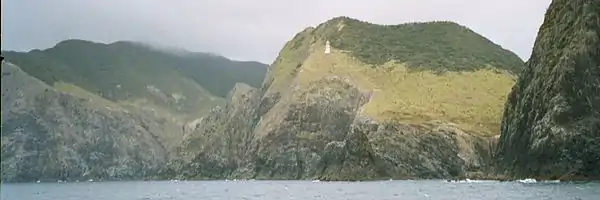
Cape Brett Lighthouse stands at the end of the peninsula, which rises to 360 metres at its northern end. A noted landmark, the natural arch "Hole in the Rock" of Piercy Island lies about 500 metres off the cape.
Island Getaway Tours, who operate Boat Cruises & Island Tours, are the only cruise company in the Bay of Islands approved by the Motu Kōkako Ahu Whenua Trust to visit, and share the history of the island and make contributions to the trust in recognition of the owners' mana whenua/mana moana rights
A predator proof fence across the peninsula excludes the brushtail possum, an introduced animal pest, which feeds on the pohutukawa tree to such an extent that the tree can eventually die.
The peninsula includes Opourua/Oke Bay, off Rawhiti Road, about 29 km from Russell.[2]
References
- "Place name detail: Cape Brett Peninsula". New Zealand Gazetteer. New Zealand Geographic Board. Retrieved 25 March 2010.
- Donald, Darroch (2007). Footprint New Zealand (4th ed.). Footprint Travel Guides. p. 180. ISBN 1-906098-04-2.