Cape St. Francis (Newfoundland and Labrador)
The headland of Cape St. Francis is the outer extremity marking the boundary of Conception Bay on the Avalon Peninsula of the island of Newfoundland in the Canadian province of Newfoundland and Labrador. The International Maritime Organization also designates Cape St. Francis as the southern extremity of the Labrador Sea.
Cape St. Francis | |
|---|---|
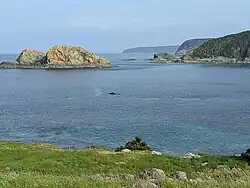 Biscayan Cove, as seen from Cape St. Francis | |
| Location | 47°48′34.18″N 52°47′09.12″W |
| Part of | Avalon Peninsula, Newfoundland and Labrador |
| Offshore water bodies | Biscayan Cove (east), Big Cove North (west), Labrador Sea (north) |
| Cape St. Francis Lighthouse | |
| Constructed | 1877 (first) |
| Construction | concrete building |
| Height | 3 m (9.8 ft) |
| Shape | lantern atop a 1-storey fog signal building[1][2] |
| Markings | white building with a broad vertical stripe |
| Operator | Canadian Coast Guard |
| Fog signal | 1 blast every 30s. |
| First lit | 1957 (current) |
| Focal height | 29 m (95 ft) |
| Range | 15 nmi (28 km; 17 mi) |
| Characteristic | Fl W 5s |
References
- Rowlett, Russ. "Lighthouses of Canada: Southeastern Newfoundland". The Lighthouse Directory. University of North Carolina at Chapel Hill. Retrieved 2017-02-07.
- List of Lights, Pub. 110: Greenland, The East Coasts of North and South America (Excluding Continental U.S.A. Except the East Coast of Florida) and the West Indies (PDF). List of Lights. United States National Geospatial-Intelligence Agency. 2016.
External links
- Aids to Navigation Canadian Coast Guard
This article is issued from Wikipedia. The text is licensed under Creative Commons - Attribution - Sharealike. Additional terms may apply for the media files.