Capture of Agra
The Capture of Agra Fort ended a month-long siege by Suraj Mal on 12 June 1761. After a one month siege of Agra the Mughal army, led by Mirza Fazilka Khan, surrendered to the Jat army.[6] The Jat possessed himself of all the wealth of the Mughal Empire and thus became one of the richest man on the planet. The Jats seized the old capital of Mughal Empire. It remained in possession of Bharatpur State rulers until 1774.[7]
| Capture of Agra Fort | |||||||||
|---|---|---|---|---|---|---|---|---|---|
| Part of Mughal-Jat Wars | |||||||||
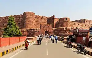
 Present-day view of Agra Fort | |||||||||
| |||||||||
| Belligerents | |||||||||
|
|
| ||||||||
| Commanders and leaders | |||||||||
| Maharaja Suraj Mal |
Mirza Fazilka Khan Mughal Faujdar of Agra | ||||||||
Background
Jats began to expand the boundaries of their kingdom. They expanded their territory to eastern Rajasthan, western Uttar Pradesh, southern Haryana, and Delhi. The Jat ruler of Bharatpur Suraj Mal controlled over the Braj region. Agra had to be merged with his territory to dominate.
Battle
Surajmal's army (four thousand Jat soldiers) advanced towards Agra. After a month's siege, on 12 June 1761, Surajmal offered peace terms and promised the Qiledar, Fazilka Khan, one lakh money with five villages and Agra Fort came under the control of Surajmal. They also melted the two silver doors of the famous Mughal monument Taj Mahal.[8][9] It remained under the control of Bharatpur rulers until 1774.[7] After the Jats captured the fort of Agra, the Jats had stuffed straw in the Taj Mahal of Agra.
Aftermath
After capturing Agra Fort, Suraj Mal became more powerful and dominant. He now became the ruler of the area of Yamuna. For the Jats, the capture of Agra was an emotional moment. About 90 years ago, just a short distance away from the gate of this fort, Gokula was cut and thrown. Surajmal thus avenged himself. Jats ruled Agra for 13 years from 1761 to 1774.[7] In 1774 the Mughal Commander Mirza Najaf Khan re-captured Agra.
See also
References
- Maheshwari, Anil (1996). Taj Mahal: Moon Still Shines : an Environmental Mess. Ajanta Publications.
- Bhatia, O. P. Singh (1968). History of India, from 1707 to 1856. Surjeet Book Depot. p. 536.
- Sarkar, Sir Jadunath (1950). Fall of the Mughal Empire: 1754–1771. (Panipat) 2d ed., rev. 1950. M.C. Sarkar.
- "University of Kerala. Dept. of History, University of Allahabad. Dept. of Modern Indian History, University of Kerala, University of Travancore". Journal of Indian History, Volumes 48–49. University of Kerala. 1970.
{{cite book}}: CS1 maint: location missing publisher (link) - Edwardes, Michael (1970). King of the World: the Life and Times of Shah Alam: Emperor of Hindustan. Secker & Warburg. ISBN 9780436140914.
- Sarkar, Sir Jadunath (1950). Fall of the Mughal Empire: 1754–1771. (Panipat) 2d ed., rev. 1950. M.C. Sarkar. pp. 143–144.
- Bhanu, Dharma (1979). The Province of Agra: Its History and Administration. Concept Publishing Company. p. 9.
- Gaur, Albertin (June 1991). "George Michell: The Penguin guide to the monuments of India, I: Buddhist, Jain, Hindu. 519 pp. New York and London: Viking, 1989. £30. - Philip Da Vies: The Penguin guide to the monuments of India, II: Islamic, Rajput, European. 604 pp. New York and London: Viking, 1989. £30". Bulletin of the School of Oriental and African Studies. 54 (2): 396–397. doi:10.1017/s0041977x00015184. ISSN 0041-977X.
- Tadgell, Christopher (2002). The history of architecture in India : from the dawn of civilization to the end of the Raj. Phaidon Press. ISBN 0-7148-2960-9. OCLC 749500267.