Castlehill Fort
Castlehill was a Roman fort on the Antonine Wall in Scotland.[2]
| Castlehill Fort | |
|---|---|
 Castle Hill, East Dunbartonshire[1] | |
| Founded during the reign of | Antoninus Pius |
| Place in the Roman world | |
| Province | Britannia |
| Stationed military units | |
| — Legions — | |
| 20th 6th | |
| Location | |
| County | East Dumbartonshire |
| Country | |
Location
The fort is located in East Dunbartonshire, west of Bearsden and east of Duntocher, south of the A810 Duntocher Road.[3] Its neighbouring forts are Bearsden to the east and Duntocher to the west although there is a fortlet at Cleddans in between, with Hutcheson Hill nearer still.[4] A circular enclosed plantation of beech trees is about all a visitor can see nowadays.[5] The summit of Castlehill provides a wide panorama overlooking many historical finds.[6]
It's sometimes hard to see the exact line of the Antonine Wall at the location but there is some existing signage.[7]
In the 1900s several historians gave their own idiosyncratic descriptions of the site.[8]
Finds

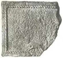
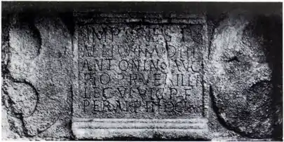
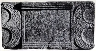
Two Roman distance slabs[19] were found at the site. One can be compared with another found near Summerston. Both these similar slabs, like two others from Duntocher have two decorative pelta shields, one on either side of the slab. The horns of each shield are embellished with three rosettes on the Castlehill slab whereas the Summerston slab has these end in two griffins' heads.
The first, badly weathered, slab has four rosettes between the shields and the inscription. It was found in 1803 on Low Millochan farm. The farm, later called East Millichen, is near Summerston.[20] It was built into a dovecot and records the building of 3666.5 paces of wall by the Sixth Legion. MacDonald describes the work as course and relates that some of the abbreviations are unusual. He suggests that it stood side-by-side with what he calls no. 6 (RIB 2193) at Summerston. On the similar Castlehill slab (RIB 2196) he suggests the stone-cutter has blundered and made a letter P where he should have a letter F (for Fidelis) on the fourth line. The Castlehill slab also records 3666.5 paces although the units used are a matter of ongoing research.[21]
Another was found by a neighbouring farmer in 1826.[22]
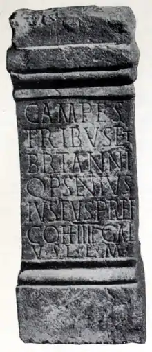
A Roman altar was found in the same year.[23]
Many Roman forts along the wall held garrisons of around 500 men.[24] Larger forts like Castlecary and Birrens had a nominal cohort of 1000 men[25] but probably sheltered women and children[26] as well although the troops were not allowed to marry.[27] There is likely too to have been large communities of civilians around the site.[28]
.jpg.webp)

References
- "Castlehill". OpenStreetMap. Retrieved 18 November 2017.
- "Castlehill". CANMORE. Royal Commission on the Ancient and Historical Monuments of Scotland. Retrieved 18 November 2017.
- "Castlehill". OpenStreetMap. Retrieved 18 November 2017.
- "OS 25 inch map 1892-1949, with Bing opacity slider". National Library of Scotland. Ordnance Survey. Retrieved 12 October 2017.
- Keppie, L. J. F. "The Roman Fort(s) on Castlehill, Bearsden". University of Edinburgh. Retrieved 18 November 2017.
- Macdonald, Sir George (1934). The Roman wall in Scotland, by Sir George Macdonald (2d ed., rev., enl., and in great part rewritten ed.). Oxford: The Clarendon press. pp. 170–173. Retrieved 11 October 2017.
- "CASTLEHILL: FORT" (PDF). Frontiers of the Roman Empire. Retrieved 18 November 2017.
- Macdonald, Sir George (1934). The Roman wall in Scotland, by Sir George Macdonald (2d ed., rev., enl., and in great part rewritten ed.). Oxford: The Clarendon press. pp. 326–328. Retrieved 11 October 2017.
- "East Millichen". Canmore. Historic Environment Scotland. Retrieved 5 May 2018.
- Macdonald, Sir George (1934). The Roman wall in Scotland, by Sir George Macdonald (2d ed., rev., enl., and in great part rewritten ed.). Oxford: The Clarendon press. pp. 376–377. Retrieved 11 October 2017.
- "Distance Slab from the Antonine Wall (A.1942.18)". Sketchfab. glasgowmuseums. Retrieved 5 May 2018.
- "RIB 2196. Distance Slab of the Sixth Legion". Roman Inscriptions of Britain. Retrieved 18 November 2017.
- Macdonald, Sir George (1934). The Roman wall in Scotland, by Sir George Macdonald (2d ed., rev., enl., and in great part rewritten ed.). Oxford: The Clarendon press. pp. 377–381. Retrieved 11 October 2017.
- "RIB 2197. Distance Slab of the Twentieth Legion Valeria Victrix". Roman Inscriptions of Britain. Retrieved 18 November 2017.
- Macdonald, Sir George (1934). The Roman wall in Scotland, by Sir George Macdonald (2d ed., rev., enl., and in great part rewritten ed.). Oxford: The Clarendon press. pp. 381–383. Retrieved 11 October 2017.
- "RIB 2195. Altar dedicated to the Goddesses of the Parade-ground and Britannia". Roman Inscriptions of Britain. Retrieved 18 November 2017.
- Macdonald, Sir George (1934). The Roman wall in Scotland, by Sir George Macdonald (2d ed., rev., enl., and in great part rewritten ed.). Oxford: The Clarendon press. pp. 433–434. Retrieved 11 October 2017.
- "Altar, Castlehill". Retrieved 18 November 2017.
- "Distance Slabs". The Antonine Wall. CastlesFortsBattles.co.uk network. Retrieved 27 October 2017.
- "OS 25 inch map 1892-1949, with Bing opacity slider". National Library of Scotland. Ordnance Survey. Retrieved 12 October 2017.
- Krakowka, Kathryn. "Meticulous metric survey of the Antonine Wall". Current Archaeology. Retrieved 28 April 2018.
- MacDonald, Hugh (1856). Rambles Round Glasgow (2nd ed.). Glasgow: Thomas Murray and Son. pp. 307–310. Retrieved 30 November 2017.
- Brotchie, T.C.F. (1921). Some Sylvan Scenes near Glasgow. Glasgow: Aird & Coghill. p. 94. Retrieved 3 December 2017.
- "Soldier". Frontiers of the Roman Empire. Retrieved 21 October 2017.
- Miller, S. N. (1952). The Roman Occupation Of South Western Scotland Being Reports Of Excavations And Surveys Carried Out Under The Auspices Of The Glasgow Archaeological Society By John Clarke, J. M. Davidson, Anne S. Robertson, J. K. St. Joseph, Edited For The Society With An Historical Survey By S. N. Miller. Glasgow: Robert Maclehose & Company Limited. Retrieved 11 October 2017.
- "Children". Frontiers of the Roman Empire. Retrieved 21 October 2017.
- "Roman child's leather shoe". A History of the World. BBC. Retrieved 17 October 2017.
- Rohl, Darrell, Jesse. "More than a Roman Monument: A Place-centred Approach to the Long-term History and Archaeology of the Antonine Wall" (PDF). Durham Theses. Durham University. Available at Durham E-Theses Online ref: 9458. Retrieved 14 October 2017.
{{cite web}}: CS1 maint: multiple names: authors list (link)
- "distance slab of the Sixth Legion, recording the completion of 3666.5 paces". Hunterian Museum Archaeology & Ethnography Collections: GLAHM F.6. University of Glasgow. Archived from the original on 1 December 2017. Retrieved 18 November 2017.
- "distance slab of the Twentieth Legion, recording the completion of 3000 feet". Hunterian Museum Archaeology & Ethnography Collections: GLAHM F.6. University of Glasgow. Archived from the original on 1 December 2017. Retrieved 18 November 2017.
- "altar, to Matres Campestres & Britannia". Hunterian Museum Archaeology & Ethnography Collections: GLAHM F.6. University of Glasgow. Archived from the original on 1 December 2017. Retrieved 18 November 2017.


