Caledon, Ontario
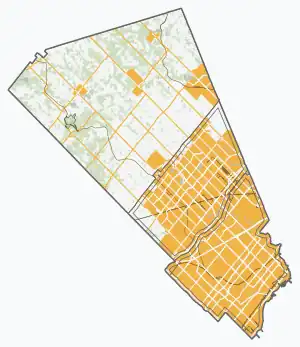
Caledon (/ˈkælədən/; 2021 population 76,581) is a town in the Regional Municipality of Peel in the Greater Toronto Area of Ontario, Canada. The name comes from a shortened form of Caledonia, the Roman name for what is now Scotland. Caledon is a developing urban area, but it remains primarily rural.[7] It consists of an amalgamation of a number of urban areas, villages, and hamlets. Its major urban centre is Bolton, on its eastern side, adjacent to York Region.
Caledon | |
|---|---|
| Town of Caledon | |
.jpg.webp) | |
 Flag Logo | |
 Caledon 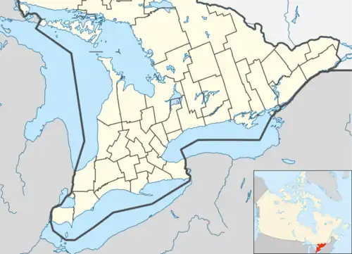 Caledon | |
| Coordinates: 43°51′58″N 79°51′32″W[1] | |
| Country | Canada |
| Province | Ontario |
| Regional municipality | Peel Region |
| Established | January 1, 1974 |
| Government | |
| • Mayor | Annette Groves |
| • Governing Body | Caledon Town Council |
| • MP | Kyle Seeback (CPC) |
| • MPP | Sylvia Jones (PC) |
| Area | |
| • Land | 688.82 km2 (265.95 sq mi) |
| Highest elevation | 485 m (1,591 ft) |
| Lowest elevation | 221 m (725 ft) |
| Population | |
| • Total | 76,581 |
| • Density | 111.2/km2 (288/sq mi) |
| Time zone | UTC−05:00 (EST) |
| • Summer (DST) | UTC−04:00 (EDT) |
| Forward sortation area | |
| Area code(s) | 905, 519 |
| Website | www |
Caledon is one of three municipalities of Peel Region. The town is at the northwest border of the city of Brampton. At over 688 km2 (266 sq mi), Caledon is the largest municipality by area in the Greater Toronto Area.
History
By 1869, Belfountain was a village with a population of 100 in the Township of Caledon County Peel. It was established on the Credit River. There were stagecoaches to Erin and Georgetown. The average price of land was $20.[8]
In 1973, Caledon acquired more territory when Chinguacousy dissolved, with most sections north of Mayfield Road (excluding Snelgrove) transferred to the township.
Caledon inherited the name from Caledon Township of Peel County, Ontario, in 1974, which was likely named by settlers like Edward Ellis, who came from the area around Caledon, County Tyrone, now in Northern Ireland, or by public voting.[9]
In 1974, Peel County's 10 municipalities became the Region of Peel's 3 municipalities. The Town of Caledon was created from the villages of Bolton and Caledon East, the townships of Albion and Caledon, and the north half of Chinguacousy.
Demographics
| Year | Pop. | ±% |
|---|---|---|
| 1981 | 26,645 | — |
| 1991 | 34,965 | +31.2% |
| 1996 | 39,893 | +14.1% |
| 2001 | 50,595 | +26.8% |
| 2006 | 57,050 | +12.8% |
| 2011 | 59,460 | +4.2% |
| 2016 | 66,502 | +11.8% |
| 2021 | 76,581 | +15.2% |
| Source: Statistics Canada | ||
In the 2021 Canadian census, conducted by Statistics Canada, Caledon had a population of 76,581 living in 23,699 of its 24,795 total private dwellings, a change of 15.2% from its 2016 population of 66,502. With a land area of 688.82 km2 (265.95 sq mi), it had a population density of 111.2/km2 (287.9/sq mi) in 2021.[6]
In 2021, the median age was 40.8 years old, slightly lower than the provincial median of 41.6 years old.[10] Caledon's population is made of 49.8% women and 50.2% men.[11] There were 24,795 private dwellings. According to the 2011 National Household Survey, the median value of a dwelling in Caledon is $474,087, significantly higher than the national average of $280,552. The median household income (after-taxes) in Caledon is $83,454, much higher than the national average of $54,089. The average individual's income was $53,870.[12]
According to the 2021 Census, the largest five ethnic origins of the residents of Caledon are Italian (17,630; 23.2%), English (10,320; 13.6%), Indian (9,120; 12.0%), Scottish (8,270; 10.9%), and Canadian (8,095; 10.6%).[10] English is the mother tongue of 65.4% of the residents of Caledon. Native speakers of Punjabi make up 11.1% of the town's population, Italian 5.4%, Portuguese 1.4%, Spanish 1.3%, and Polish 1.0%.[10]
As of 2021,[10] 58.5% of Caledon's population was Christian, down from 77.5% in 2011.[13] 38.2% of residents were Catholic, 10.5% were Protestant, 6.0% were Christian without precision, 1.8% were Christian Orthodox, and 2.0% belonged to other Christian denominations or Christian-related traditions; 19.3% of the population was non-religious or secular, up from 18.6% in 2011. All other religions and spiritual traditions accounted for 22.2% of the population, up from 3.9% in 2011. They included Sikhism (14.3%), Hinduism (4.7%), Islam (2.1%), Buddhism (0.5%), and Judaism (0.4%).
66.3% of Caledon residents were white/European, 32.8% were visible minorities, and 0.8% were Indigenous. The largest visible minority groups were South Asian (21.4%), Black (3.6%), Latin American (1.7%), Chinese (1.0%) and Filipino (1.0%)
Government
The town is run by a mayor and six municipal councillors:
- Mayor Annette Groves
- Councillor Ward 1 Lynn Kiernan
- Councillor Ward 2 Dave Sheen
- Councillor Ward 3 Doug Maskell
- Councillor Ward 4 Nick deBoer
- Councillor Ward 5 Tony Rosa
- Councillor Ward 6 Cosimo Napoli
It is on Peel Regional Council by the following:[14]
- Mayor Annette Groves
- Regional Councillor Ward 1, 2, 3 Christina Early
- Regional Councillor Ward 4, 5, 6 Mario Russo
Per capita, Caledon has by far the largest representation on Peel Regional Council of the three municipalities.
Climate
| Climate data for Albion Field Centre (Albion Township and Caledon) Climate ID: 6150103; coordinates 43°55′N 79°50′W; elevation: 281.9 m (925 ft); 1981–2010 normals | |||||||||||||
|---|---|---|---|---|---|---|---|---|---|---|---|---|---|
| Month | Jan | Feb | Mar | Apr | May | Jun | Jul | Aug | Sep | Oct | Nov | Dec | Year |
| Record high °C (°F) | 12.0 (53.6) |
14.5 (58.1) |
24.5 (76.1) |
30.0 (86.0) |
33.0 (91.4) |
34.5 (94.1) |
36.1 (97.0) |
35.0 (95.0) |
34.4 (93.9) |
30.6 (87.1) |
22.2 (72.0) |
19.5 (67.1) |
36.1 (97.0) |
| Average high °C (°F) | −2.8 (27.0) |
−1.4 (29.5) |
3.7 (38.7) |
11.6 (52.9) |
18.8 (65.8) |
23.7 (74.7) |
26.3 (79.3) |
25.1 (77.2) |
19.9 (67.8) |
13.2 (55.8) |
5.8 (42.4) |
−0.3 (31.5) |
12.0 (53.6) |
| Daily mean °C (°F) | −7.0 (19.4) |
−5.9 (21.4) |
−1.4 (29.5) |
6.1 (43.0) |
12.4 (54.3) |
17.3 (63.1) |
19.9 (67.8) |
19.1 (66.4) |
14.3 (57.7) |
8.1 (46.6) |
2.1 (35.8) |
−3.9 (25.0) |
6.7 (44.1) |
| Average low °C (°F) | −11.2 (11.8) |
−10.4 (13.3) |
−6.6 (20.1) |
0.5 (32.9) |
5.9 (42.6) |
10.9 (51.6) |
13.5 (56.3) |
13.0 (55.4) |
8.6 (47.5) |
2.9 (37.2) |
−1.7 (28.9) |
−7.4 (18.7) |
1.5 (34.7) |
| Record low °C (°F) | −36.5 (−33.7) |
−35.0 (−31.0) |
−31.5 (−24.7) |
−21.1 (−6.0) |
−6.1 (21.0) |
−1.5 (29.3) |
1.7 (35.1) |
−0.5 (31.1) |
−5.0 (23.0) |
−11.5 (11.3) |
−19.0 (−2.2) |
−32.0 (−25.6) |
−36.5 (−33.7) |
| Average precipitation mm (inches) | 60.4 (2.38) |
50.2 (1.98) |
50.3 (1.98) |
67.0 (2.64) |
76.1 (3.00) |
75.5 (2.97) |
81.8 (3.22) |
77.4 (3.05) |
75.0 (2.95) |
68.3 (2.69) |
81.7 (3.22) |
57.7 (2.27) |
821.5 (32.34) |
| Average rainfall mm (inches) | 24.0 (0.94) |
22.2 (0.87) |
27.3 (1.07) |
63.0 (2.48) |
76.1 (3.00) |
75.5 (2.97) |
81.8 (3.22) |
77.4 (3.05) |
75.0 (2.95) |
64.9 (2.56) |
67.8 (2.67) |
25.9 (1.02) |
681.0 (26.81) |
| Average snowfall cm (inches) | 36.4 (14.3) |
28.0 (11.0) |
23.0 (9.1) |
4.0 (1.6) |
0.0 (0.0) |
0.0 (0.0) |
0.0 (0.0) |
0.0 (0.0) |
0.0 (0.0) |
3.4 (1.3) |
13.8 (5.4) |
31.9 (12.6) |
140.5 (55.3) |
| Average precipitation days (≥ 0.2 mm) | 12.4 | 9.4 | 9.6 | 10.8 | 10.3 | 10.2 | 9.0 | 9.8 | 10.8 | 11.3 | 12.1 | 9.8 | 125.5 |
| Average rainy days (≥ 0.2 mm) | 3.3 | 3.6 | 5.2 | 9.9 | 10.3 | 10.2 | 9.0 | 9.8 | 10.8 | 11.2 | 9.3 | 3.7 | 96.2 |
| Average snowy days (≥ 0.2 cm) | 9.8 | 6.4 | 5.3 | 1.4 | 0.1 | 0.0 | 0.0 | 0.0 | 0.0 | 0.6 | 4.0 | 6.8 | 34.3 |
| Source: Environment and Climate Change Canada[15] | |||||||||||||
Education
The Peel District School Board operates the secular schools in Caledon. As of 2023, it operated 259 schools in Peel Region, serving 153,000 students. The Dufferin-Peel Catholic District School Board operates Catholic schools for the region, including Caledon. As of 2023, it operated 151 schools serving nearly 74,000 students.
The Conseil scolaire Viamonde operates secular francophone schools serving the area. The Conseil scolaire de district catholique Centre-Sud operates Catholic francophone schools serving the area.
School (Location)
- Allan Drive Middle School (Bolton)
- Alloa Public School (Caledon)
- Alton Public School (Alton)
- Belfountain Public School (Belfountain)
- Brampton Christian School (Private)
- Caledon Central Public School (Caledon Village)
- Caledon East Public School (Caledon East)
- Countryside Montessori and Private School
- Creative Children's Montessori School (Bolton)
- Ellwood Memorial Public School (Bolton)
- Herb Campbell Public School (Campbell's Cross)
- Headwater Hills Montessori School (Private)
- The Hill Academy
- Holy Family Elementary School (Bolton)
- Humberview Secondary School (Bolton)
- Huttonville Public School (Huttonville)
- King's College School (Private)
- James Bolton Public School (Bolton)
- Macville Public School (Bolton)
- Mayfield Secondary School (Caledon)
- Mind Valley Montessori and Private School (Bolton)
- Palgrave Public School (Palgrave)
- St. John Paul II Elementary School (Bolton)
- Robert F. Hall Catholic Secondary School (Caledon East)
- SouthFields Village Public School (Southfields Village)
- St. Cornelius Elementary School (Caledon East)
- St. John the Baptist Elementary School (Bolton)
- St. Nicholas Elementary School (Bolton)
- St Michael Catholic Secondary School (Bolton)
- Tony Pontes Public School (Caledon)
Culture
The Alton Mill Arts Centre is located in Caledon.[16] Art galleries include Headwaters Arts[17] and Peel Art Gallery, Museum and Archives.[18]
Media
Established in 1888 as the Cardwell Observer,[19] The Caledon Enterprise is published weekly from Bolton by Metroland Media.[20] Also based out of Bolton is The Caledon Citizen, established in 1982. A MELINIUM paper, it is published by Caledon Publishing Ltd.[21] A third newspaper, launched by Rick and Shelly Sargent in 2010, The Regional, was published monthly in Bolton. In November 2012, the paper was acquired by Caledon Publishing and ceased publication. The Sargents began working with the Caledon Citizen.
In January 2015 an online publication specific to Caledon, JustSayinCaledon.com, was started by former Bolton Ward 5 Regional Councillor Patti Foley. It publishes stories about local residents and businesses, Caledon event listings, town council highlights, opinion pieces, and a food section about local markets and restaurants.
A short-lived student-run newspaper, The Caledon Underground, was published in 2010.
The creepypasta 1999 depicts a fictional television station based in Caledon, called Caledon Local 21, which was on the air from 1997 to 1999 in the broadcast area of stations in the Greater Toronto Area and Hamilton.[22]
Key Porter Books and its parent H.B. Fenn are headquartered in Bolton. The radio stations CJFB-FM and CFGM-FM are broadcast.
History and trails
- Old Township Hall (built c.1875, now used as a theatre)[23]
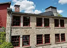
- Millcroft Inn (woollen mill, built in 1881, now a hotel)[24]
- Alton Mill (woollen mill, c.1881, now an arts centre)[25]
- Brick Work Ruins (Caledon)
- Bruce Trail (Caledon)
- Caledon Trailway (Caledon)
- Canadian Heritage Humber River (Caledon)
- Elora-Cataract Trail (Caledon)
- Grand Valley Trail (Caledon)
- Great War Flying Museum (Caledon)
- Humber Valley Trail (Caledon)
- Andrew's Treasure Trail (Caledon)
- Oak Ridges Trail (Caledon)
- Hair Pin Turn (Beside the Credit River)
- Caledon Central Public School
Organizations
- Freemasonry
- Caledon Ski Club
- Kinsmen Club Christmas Parade
- Columbian Squires
- Knights of Columbus
Protected areas

- Albion Hills Conservation Area
- Alton Grange Property [26]
- Belfountain Conservation Area
- Caledon Lake Forest Conservation Area
- Forks of the Credit Provincial Park
- Glen Haffy Conservation Area
- Ken Whillans Conservation Area
- Palgrave Forest and Wildlife Area
- Robert Baker Forest Conservation Area
- Terra Cotta Conservation Area
- Warwick Conservation Area
Sports and recreation
Junior hockey teams include the Caledon Admirals (Jr. A), Caledon Bombers (Jr. B) and the Caledon Golden Hawks (Jr. C). The Caledon Canadians are now defunct.
Minor hockey teams include the Caledon Hawks and the Caledon Coyotes.
Lacrosse in Caledon is represented by the Caledon Vaughan Minor Lacrosse Association, which operates Minor Field and both minor and junior C box teams.
Mike Fox, the winner of the 2007 Queen's Plate, was foaled in Caledon, and Peaks and Valleys currently stands there.
Caledon Equestrian Park, in Palgrave, hosted the equestrian events of the 2015 Pan American Games.[27]
Communities
The primary administrative and commercial centre of Caledon is the community of Bolton, which the municipal government estimated as having a population of 26,478 in 2006.[28]
Aside from Bolton, other smaller communities in Caledon include the following:
- Rural service centres (i.e.: townlets or large villages): Caledon East, Mayfield West
- Villages: Alton, Caledon, Cheltenham, Inglewood, Mono Mills, Palgrave
- Hamlets: Albion, Belfountain, Brimstone (Brimstone Point), Campbell's Cross, Cataract, Claude, Melville, Mono Road, Terra Cotta, Wildfield
- Industrial/commercial centres: Sandhill, Tullamore, Victoria
- Other localities: Alloa, Boston Mills, Caledon Village, Castlederg, Cedar Meadows, Cedar Mills, Coulterville, Ferndale, Forks of the Credit, The Grange, Humber, Humber Grove, Kilmanagh, Lockton, Macville, McLeodville, New Glasgow, Palgrave Estates, Queensgate, Rockside, Rosehill, Silver Creek, Sleswick, Sligo, Star, Stonehart, Taylorwoods, Tormore, Valleywood
The region is otherwise very sparsely populated, with farms being the only residential centres.
Former localities
Former villages and hamlets include:
- Kennedy's Corners (Old School Road and Airport Road)
- Fox's Corners (Willoughby Road and Charleston Side Road)
- Greenlaw (The Grange Sideroad and Winston Churchill Boulevard)
- Caldwell (The Grange Sideroad and Kennedy Road)
- Caldwell Junction (Olde Baseline Road and Moutainview Road)
- Glencoe's Corners (Olde Baseline Road and Creditview Road)
- McBride's Corners (Olde Baseline Road and Hurontario Street)
Infrastructure
Emergency services
Caledon runs its own fire services through the composite career and volunteer firefighters of the Town of Caledon Fire & Emergency Services, which has nine stations.
Ambulance services are run by the regional government's Peel Regional Paramedic Services, with three stations (#10, 11 and 12).
Despite being part of Peel Region, Caledon has its policing conducted from Ontario Provincial Police Caledon Detachment, rather than Peel Regional Police. The OPP also patrols the provincial highways in Caledon (Ontario Highway 9 and Ontario Highway 10).
Transportation
GO Transit operates two bus routes in Caledon:
- serving Bolton along Peel Regional Road 50 and through east Mississauga and connecting with Malton GO Station on the Kitchener line.
- serving Orangeville and Brampton and connecting with Brampton GO Station on the Georgetown line via Main Street/Highway 10.
Caledon additionally has storage and service facilities.
Selected trips by Brampton Transit's Route 30 Airport Road buses extend into the Tullamore Industrial Area of the Town of Caledon, with a total of six trips per day.[29]
The town has no government-supported local public transit system. However, a growing population prompted the former local resident Darren Parberry to start a trial bus service with two routes, called Métis Transit, which ran briefly in 2006.[30] Caledon also ran a commercial bus operation in 1999 under the name Caledon Transit Incorporated,[31] but it ceased operations because of low ridership.
Transit services for the elderly, disabled, and infirm are provided by Caledon Community Services Transportation and Transhelp. Both are run by the Region of Peel Accessible Transportation Services.
Taxi service is also available in the Bolton area.
The highways in the municipality are:
- Airport Road or Peel Regional Road 7
- Hurontario Street or Highway 10
- Charleston Sideroad or Peel Regional Road 24 (formerly Highway 24)
- Queen Street or Peel Regional Road 50 (formerly Highway 50)
- Main Street and Porterfield Road, or Peel Regional Road 136 (formerly Highway 136)
- Highway 410 (to Highway 10)
Notable people
References
- "Caledon". Geographical Names Data Base. Natural Resources Canada.
- "Caledon". Geographical Names Data Base. Natural Resources Canada.
- Statistics Canada: 2012
- 43° 51' 44" N, 80° 8' 13" W, as per Google Earth
- 43° 49' 15" N, 79° 43' 34" W, as per Google Earth
- "Population and dwelling counts: Canada, provinces and territories, census divisions and census subdivisions (municipalities), Ontario". Statistics Canada. February 9, 2022. Retrieved March 30, 2022.
- Hamilton, William (1978). The Macmillan Book of Canadian Place Names. Toronto: Macmillan. p. 139. ISBN 0-7715-9754-1.
- The province of Ontario gazetteer and directory. H. McEvoy Editor and Compiler, Toronto: Robertson & Cook, Publishers, 1869, https://babel.hathitrust.org/cgi/pt?id=hvd.32044081323123&view=1up&seq=58&q1=caledon%20$20, accessed 23 October 2020
- "Heritage Designation Report: Edward Ellis House" (PDF). Caledon.ca. Archived from the original (PDF) on September 23, 2015. Retrieved 7 November 2017.
- Canada, Statistics (October 26, 2022). "Census Profile, 2021 Census". Retrieved October 26, 2022.
- "Demographics in Caledon".
- Canada, Statistics (2017). "Census Profile, 2016 Census". Statistics Canada. Retrieved 31 October 2018.
- Government of Canada, Statistics Canada (2013-05-08). "2011 National Household Survey Profile - Census subdivision". www12.statcan.gc.ca. Retrieved 2023-01-17.
- "Council". Caledon.ca. Retrieved 7 November 2017.
- "Albion Field Centre". 1981-2010 Canadian Climate Normals. Environment and Climate Change Canada. Retrieved 2016-05-12.
- "Alton Mill Arts Centre – Restoration: How the Mill came to be restored and adapted to a new use".
- "About us | Headwaters Arts".
- "In Our Community". 23 September 2021.
- Heyes, Esther (1968). The Story of Albion (PDF) (2 ed.). Bolton ON: Bolton Enterprise. p. 323. Archived from the original (PDF) on 2012-05-28. Retrieved 25 June 2012.
- "Caledon Enterprise". Metroland Media. Mississauga ON. Archived from the original on 7 July 2012. Retrieved 25 June 2012.
- "Contact Info". Archived from the original on 2012-07-02. Retrieved 2012-06-25.
- Lucia Peters (March 27, 2015). "Is This Creepypasta Story Real?". Bustle. Retrieved February 2, 2021.
- https://www.historicplaces.ca/en/rep-reg/place-lieu.aspx?id=15541, Old Caledon Township Hall, Formally Recognized: 1982/01/25
- https://www.historicplaces.ca/en/rep-reg/place-lieu.aspx?id=15530&pid=0, Millcroft Inn Formally Recognized: 1991/10/07
- https://www.historicplaces.ca/en/rep-reg/place-lieu.aspx?id=2088&pid=0, Alton Mill Formally Recognized: 2004/12/07
- "Home". altongrange.ca.
- "OLG Caledon Pan Am Equestrian Park". toronto2015.org. Pan Am / Parapan Am Games, 2015. Archived from the original on November 21, 2013. Retrieved January 11, 2019.
- "Archived copy" (PDF). Archived from the original (PDF) on 2011-05-27. Retrieved 2008-07-28.
{{cite web}}: CS1 maint: archived copy as title (link) - "Schedules and Maps – Route 30" (PDF). Brampton Transit. Retrieved January 11, 2019.
- "Wanted: Passengers for Bus Line". Archived from the original on 2010-02-17. Retrieved 2010-01-25.
- "Transit History of Ontario Communities (A-B)". Home.cc.umanitoba.ca. Retrieved 7 November 2017.
Sources
- "Caledon, Ontario (Code 3521024) Census Profile". 2011 census. Government of Canada - Statistics Canada. Retrieved 2012-03-01.
External links
Places adjacent to Caledon, Ontario | |
|---|---|
Largest city: Toronto | ||
| Regions | 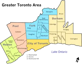 | |
| Cities | ||
| Towns | ||
| Townships | ||
| Municipalities | ||