El-Sheikh
El-Sheikh (Somali: Ceel-Sheekh) is a coastal settlement in the western edge of the Awdal region of Somaliland.[1][2][3][4]
El-Sheikh
Buurta Almis, جبل ألمس | |
|---|---|
Town | |
 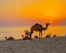  A beach in El-Sheikh | |
| Country | |
| Region | Awdal |
| District | Lughaya |
| Time zone | UTC+3 (EAT) |
History
El-Sheikh was also known historically as Buurta Almis or جبل ألمس Jebel Amis after the nearby Mount Almis just south of the settlement. It was a well known landmark to navigators and legendary Arab explorer Ahmad ibn Mājid wrote of El-Sheikh and a few other notable landmarks and ports of the northern Somali coast, including Berbera, Siyara, the Sa'ad ad-Din islands aka the Zeila Archipelago near Zeila, Alula, Maydh, Ruguda, Heis and El-Darad.[5] Richard Burton visited the settlement and noted the mountain in his map.[6]
After the Maxamed Case massacre of Richard Burton's travel party and death of a number of British officers in 1854 led the Royal Navy to blockade the Habr Awal coast. The blockade was established from Mount Almis to Siyara and crippled trade in Berbera and Bulhar with a settlement being reached in 1856.[7]
El-Sheikh remained a well used by the Habr Awal Saad Musa throughout the British Somaliland period and this is noted in the late 1940s and 50s survey of the protectorate.[8]
Demographics
The Bahabar Muse subclan of the Maxamed case Gadabursi reside in Ceel-Sheekh and its environs.[9]
References
- "UN Office for the Coordination of Humanitarian Affairs".
- Ceel Sheekh - coordinates
- Njeri, Sarah (2016). "A minefield of possibilities : the viability of liberal peace in Somaliland, with particular reference to mine action". S2CID 132393831.
{{cite web}}: Missing or empty|url=(help) - "Ceel Sheekh: Magaalo Soomaaliyeed oo ay quruxdeeda dayacan tahay". BBC News Somali (in Somali). Retrieved 2020-09-11.
- "Ibn Majid". Medieval Science, Technology, and Medicine: An Encyclopedia. Routledge. 2005. ISBN 978-1-135-45932-1.
- Richard Burton, First Footsteps in East Africa, Preface
- Speke, John (1864). What Led to the Discovery of the Source of the Nile. Blackwood. p. 146. ISBN 9780460000505.
- Hunt, John Anthony (1951). A General Survey of the Somaliland Protectorate 1944-1950: Final Report on "An Economic Survey and Reconnaissance of the British Somaliland Protectorate 1944-1950,". p. 62.
- Sommerlatte, Malte (2000). Ecological Assessment of the Coastal Plains of North Western Somalia (Somaliland). IUCN Eastern Africa Regional Office. p. 4.
The Issa Musa are the more coastal sub-clan , and they live in the immediate environs of Berbera and extend southwards to Hargeisa. West of them but in proximity are the Sa'ad Musa, who extend from a narrow strip on the coast near Bullaxaar and El Sheikh towards the towns of Gebile and Hargeisa which they dominate, and across into their grazing lands in the rich plateau area of the 'Haud' in Ethiopia.