Central Elevated Walkway
The Central Elevated Walkway is an extensive footbridge network spanning Admiralty, Central and parts of Sheung Wan, near Victoria Harbour in Hong Kong.


| Central Elevated Walkway | |||||||||||||
|---|---|---|---|---|---|---|---|---|---|---|---|---|---|
| Traditional Chinese | 中區行人天橋 | ||||||||||||
| Simplified Chinese | 中区行人天桥 | ||||||||||||
| Literal meaning | Central District Pedestrian Bridge | ||||||||||||
| |||||||||||||
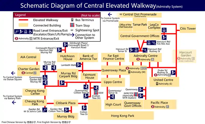
The system was built in phases by the Hong Kong Government and various developers, such as Hongkong Land, Jardine Matheson Holdings and Shun Tak Holdings. It has escalators and staircases for access. Parts of it are air-conditioned. There is another system in Admiralty that is currently not connected to the Central system.
History
In the 1970s, Hongkong Land built a footbridge over Connaught Road to facilitate pedestrian access between Connaught Place (today's Jardine House), Swire House (today's Chater House) and the General Post Office. The developer also built many footbridges between its buildings which were under construction.
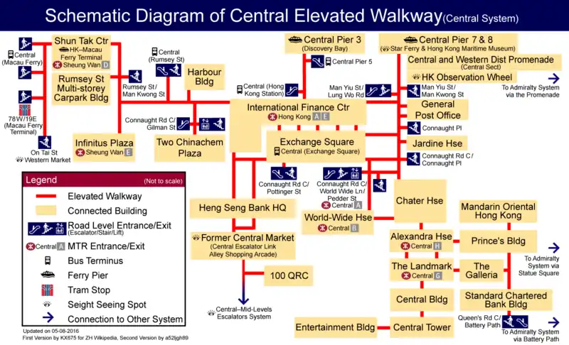
In the 1980s, after Exchange Square was completed, the government built a footbridge to connect to Hongkong Land's network; it ran west along the harbourfront to connect Central Piers and Shun Tak Centre. Other buildings along Queen's Road Central, such as Standard Chartered Bank Building and Central Tower, were also connected to the system.
In 1993, the Central–Mid-Levels escalator came into operation, and Hang Seng Bank Building was connected.
In 1998, the International Finance Centre and Airport Express Hong Kong station were completed and brought into the network.
After 2000, the government built a bridge between World-Wide House and Exchange Square.
Central system


Coverage
- East to: The Landmark, Prince's Building, MTR Hong Kong station, Central station
- South to: Hang Seng Bank main branch, Central–Mid-Levels escalator, Soho, Conduit Road
- West to: Shun Tak Centre (Sheung Wan), Hong Kong–Macau Ferry Terminal, MTR Sheung Wan station
- North to: International Finance Centre, Central Piers, MTR Hong Kong station
Connected buildings
- International Finance Centre
- City Hall
- Jardine House
- Exchange Square
- General Post Office
- World-Wide House
- Chater House
- Alexandra House
- Mandarin Oriental
- Prince's Building
- 9 Queen's Road Central
- Bank of East Asia main branch
- Standard Chartered Bank Building
- The Landmark
- Central Building
- Central Place
- Hang Seng Bank building
- Central Market
- Harbour Building
- Infinitus Plaza
- Shun Tak Centre
Admiralty system

Coverage
- East to: CITIC Tower, MTR Admiralty station
- South to: Hong Kong Park, CITIC Tower
- West to: Hutchison House, AIA Central, Cheung Kong Center
- North to: City Hall
Connected buildings
- Pacific Place
- CITIC Tower
- United Centre
- Admiralty Centre
- Queensway Plaza
- Far East Finance Centre
- Lippo Centre
- Queensway Government Offices
- Fairmont House
- Murray Road Carpark Building
- Bank of China Tower
- Cheung Kong Center
- Hong Kong Park
- Three Garden Road
- Bank of America Tower
Hutchison House(redevelopment in progress)- AIA Central
 A topological map
 Another map beside the harbour
 Section near Exchange Square
External links
- Labyrinth in the Air - TV program by Radio Television Hong Kong on the Central Elevated Walkway and the related Central–Mid-Levels Escalators System. (video archive)
- Pedestrian Footbridge System, Central: