Channahon, Illinois
Channahon (/ˈʃænəhɒn/ SHAN-ə-hon)[4] is a village in Grundy and Will counties in the U.S. state of Illinois. The population was 13,383 at the 2020 census.[3]
Channahon | |
|---|---|
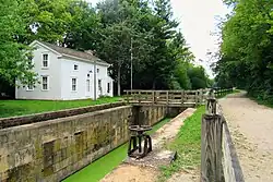
 The locktender’s house at I&M Canal Lock No. 6 | |
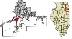
 Location of Channahon in Grundy and Will Counties, Illinois. | |
.svg.png.webp) Location of Illinois in the United States | |
| Coordinates: 41°25′46″N 88°13′43″W | |
| Country | United States |
| State | Illinois |
| County | Grundy, Will |
| Townships | Channahon, Troy, Aux Sable, Goose Lake, Saratoga |
| Incorporated | December 11, 1961 |
| Government | |
| • Village President | Missey Moorman Schumacher[1] |
| Area | |
| • Total | 16.9 sq mi (43.77 km2) |
| • Land | 15.62 sq mi (40.46 km2) |
| • Water | 1.28 sq mi (3.30 km2) |
| Elevation | 531 ft (162 m) |
| Population (2020) | |
| • Total | 13,383[3] |
| • Density | 856.7/sq mi (330.77/km2) |
| Time zone | UTC-6 (CST) |
| • Summer (DST) | UTC-5 (CDT) |
| ZIP Code(s) | 60410 |
| Area code | 815 |
| FIPS code | 17-12476 |
| Website | www |
Located in a rural area southwest of Joliet, Illinois, Channahon lies at the confluence of the Des Plaines, Kankakee, and DuPage rivers, where they form the Illinois River. The Illinois and Michigan Canal runs through the village, intersecting the DuPage at Channahon State Park. Most of the village is within Channahon Township in Will County. The current village president is Missey Moorman Schumacher.
History
Archaeological evidence suggests that the land on which the village now stands was inhabited as long as three to four thousand years ago by Mound Builders. When white settlers arrived in the early 1830s, the region was populated by Potawatomi, with whom the early settlers had friendly relations. The settlers called the area "Channahon," a Potawatomi phrase translated as "meeting of the waters."[5]
When construction of the I&M Canal began in 1836, Channahon's location was chosen as the site for two of the waterway's locks. In 1845, Myrvin Benjamin plotted a new settlement to take advantage of the two rivers and nearly-completed canal surrounding the location. First called "DuPage" for the river and then "Swifton" for the I&M Canal board president, the settlement was formally named Channahon when the township government was organized in 1850. Channahon prospered until the rise of railroad transportation in the late 19th century caused commerce and population in the canal town to decline. The Village of Channahon was first incorporated in 1896, but dissolved in 1908 to avoid a lawsuit after an automobile plummeted into the DuPage River due to a bridge failure.[5]
Becoming a mainly agricultural community after the decline of canal commerce, Channahon saw slow growth in the first half of the 20th century.[5] On December 11, 1961, the area was reincorporated as the Village of Channahon.[6] Serious development finally began in the 1970s as the village's proximity to two major interstates resulted in both residential and industrial growth (a Mobil oil refinery, two petrochemicals plants, a soybean oil production facility, CenterPoint Intermodal Center to the east in Elwood, Illinois, and numerous warehouses to the east in both Elwood and Joliet, Illinois, including Amazon and Walmart distribution centers). Channahon, once a farming community, has developed into an affluent suburb of Chicago.
Geography
According to the 2010 census, Channahon has a total area of 16.417 square miles (42.52 km2), of which 14.99 square miles (38.82 km2) (or 91.31%) is land and 1.427 square miles (3.70 km2) (or 8.69%) is water.[7]
Climate
Channahon experiences cold winters with plenty of snow. Its summers are hot and humid, with cooling rains occurring frequently. The temperatures vary from 18 °F to 84 °F on average, with extremes reaching -2 °F and 92 °F on average.
Cloud coverage in Channahon varies from month to month. The time of the year with the most clouds is October 27 to June 13. The cloudiest month on average is December, and the least cloudy month on average is August.
Channahon has differing amounts of precipitation throughout the year. The time with the most rain is between March 27 to September 24. The month with the most precipitation is June.[8]
Demographics
| Census | Pop. | Note | %± |
|---|---|---|---|
| 1900 | 261 | — | |
| 1910 | 208 | −20.3% | |
| 1970 | 1,505 | — | |
| 1980 | 3,788 | 151.7% | |
| 1990 | 4,266 | 12.6% | |
| 2000 | 7,344 | 72.2% | |
| 2010 | 12,560 | 71.0% | |
| 2020 | 13,383 | 6.6% | |
| U.S. Decennial Census[9] | |||
As of the 2020 census,[10] there were 13,383 people, 4,342 households, and 3,665 families within the village. The population density was 856.7 inhabitants per square mile (330.8/km2). There were 4,684 housing units at an average density of 277.2 per square mile (107.0/km2). The racial makeup of the village was 86.25% White, 1.27% Black or African American, 0.40% American Indian and Alaska Native, 0.74% Asian, 3.27% from other races, and 8.0% from two or more races. 10.37% of the population were Hispanic or Latino of any race.
There were 4,342 households, of which 39% had children under the age of 18 living with them, 74.8% were married couples living together, 9.8% had a male householder with no spouse or partner present, 12.1% had a female householder with no spouse or partner present, and 3.7% were cohabitating couples. 11.2% of all households were made up of individuals, and 4.4% had someone living alone who was 65 years of age or older. The average household size was 3.15 and the average family size was 3.44.
The village's population was 27.4% under the age of 18, 9.9% from 18 to 24, 22.1% from 25 to 44, 27.2% from 45 to 64, and 13.4% who were 65 years of age or older. The median age was 37.4 years. For every 100 females, there were 91.8 males. For every 100 females age 18 and over, there were 95.3 males.
The median income for a household in the village was $105,156, and the median income for a family was $111,662. The per capita income for the village was $40,721. About 2.3% of families and 3.8% of the population were below the poverty line, including 0.6% of those under age 18 and 3.7% of those age 65 or over.
Arts and culture
Historic sites
The Illinois and Michigan Canal runs through the village, where it passes the locktender's house at Canal Lock No. 6[11] as well as the Dresden Mule Barn.[12] The Briscoe Mounds stand near the Des Plaines River.[13]
Parks and recreation
Formed in 1971, the Channahon Park District maintains over 383 acres (1,550,000 m2) of public parks. Facilities include:
- Channahon State Park, offering fishing and recreation beside the DuPage River; site of Forgotten Warrior Memorial.[14]
- McKinley Woods, featuring over 4 miles of walking trails near the banks of the Des Plaines River.[15]
- Community Park, Central Park, and Arroyo Trails.
- Heritage Bluffs Public Golf Club.
- Heritage Crossing Field House, with two gymnasiums, an indoor track, and fitness center.
Government
Channahon is run by a Village Board of Trustees. The current President of the Board of Trustees is Missey Schumacher (elected in April 2015).[1] At the county level, Will County residents are located within Board District 6,[1] and are represented by Don Gould (R-Shorewood) and Joe VanDuyne (D-Wilmington).[16] Grundy County residents are part of Board District 2,[1] and they are represented by Chris Balkema (R), Debra Jo Kinsella (R), Lana Phillips (D), Eric Rasmusson (R), Greg Ridenour (R), and Deb Warning (R).[17] In the Illinois State Senate, Channahon is represented by:[1]
| District | Name | Party | First Served | Area(s) of Channahon Represented | |
|---|---|---|---|---|---|
| 38 | Sue Rezin | Republican | 2010 | Aux Sable Township, Channahon Township | |
| 42 | Linda Holmes | Democratic | 2007 | Troy Township | |
| 43 | Pat McGuire | Democratic | 2012 | Troy Township | |
In the Illinois House of Representatives, Channhon is represented by:[1]
| District | Name | Party | First Served | Area(s) of Channahon Represented | |
|---|---|---|---|---|---|
| 75 | David Welter | Republican | 2016 | Aux Sable Township, Channahon Township | |
| 84 | Stephanie Kifowit | Democratic | 2013 | Troy Township | |
| 86 | Lawrence Walsh, Jr. | Democratic | 2012 | Troy Township | |
At the federal level, Channahon is represented by: Senators Dick Durbin (D-Illinois), Tammy Duckworth (D-Illinois), and Representative Adam Kinzinger (R-16th District).[1]
References
- Channahon, Village of. "Village of Channhon Illinois". Archived from the original on 2010-11-01. Retrieved 2010-06-03.
- "2020 U.S. Gazetteer Files". United States Census Bureau. Retrieved August 15, 2023.
- "U.S. Census Bureau". U.S. Census Bureau QuickFacts: Channahon village, Illinois. Retrieved 15 August 2023.
- Brown, Donald E.; Schooley, Frank E. (1957). Pronunciation Guide for Illinois Place Names. Division of University Broadcasting, College of Journalism and Communications, University of Illinois. p. 12.
- "Rural Historic Structural Survey of Channahon Township".
- "Name of Local Government: Channahon". Name Index to Illinois Local Governments. Illinois State Archives. Retrieved 21 January 2022.
- "G001 - Geographic Identifiers - 2010 Census Summary File 1". United States Census Bureau. Archived from the original on 2020-02-13. Retrieved 2015-08-02.
- "Climate and Average Weather Year Round in Channahon Illinois, United States". Weather Spark. Weather Spark. Retrieved 23 July 2022.
- "Census of Population and Housing". Census.gov. Retrieved June 4, 2015.
- "U. S. Census Bureau". Channahon village, Illinois - Census Bureau Profile. Retrieved 17 August 2023.
- Historic American Engineering Record. "Illinois & Michigan Canal, Channahon Locktender's House, I&M Canal at Lift Lock No. 6, Channahon, Will County, IL Photos from Survey HAER IL-102". Library of Congress. Library of Congress. Retrieved 22 July 2022.
- "Then & Now: Dresden Mule Barn – Channahon". Shaw Local New Network. Shaw Local New Network. 3 August 2015. Retrieved 22 July 2022.
- "Briscoe Mounds". Forest Preserve District Will County. Forest Preserve District Will County. Retrieved 23 July 2022.
- "Channahon State Park". Illinois Department of Natural Resources. Illinois Department of Natural Resources. Retrieved 23 July 2022.
- "McKinley Woods". Accelerator. Retrieved 2022-12-01.
- Will County Board (2009). "District 6". Illinois Government, Will County. Archived from the original on 2011-07-18. Retrieved 2010-06-03.
- Illinois Government, Grundy County. "grundyco.org - Grundy County Board". Archived from the original on 2020-02-06. Retrieved 2020-02-06.