Charles Fort (Ireland)
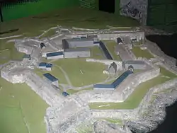
Charles Fort (Irish: Dún Chathail) is a trace italienne fortification, a bastion fort with one section of the outer wall built in star fashion. It is located at the southern end of the village of Summer Cove, on Kinsale harbour, County Cork, Ireland.[1] First completed in 1682, Charles Fort was sometimes historically referred to as the "new fort" - to contrast with James' Fort (the "old fort") which had been built on the other side of Kinsale harbour before 1607.[2] The fort is now operated as a heritage tourism site by the Heritage Ireland arm of the Office of Public Works.[3]
| Charles Fort | |
|---|---|
 Plan of fort showing layout | |
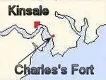
 Location relative to Kinsale | |
| Type | Bastion fort |
| Location | Kinsale harbour, County Cork, Ireland |
| Coordinates | 51.6965°N 8.4990°W |
| Built | 1670s |
| Governing body | Office of Public Works |
| Type | Guardianship |
| Reference no. | 535 |
| Description | Star-shaped-fort |
History
Charles Fort was built on the site of the ruins of an earlier stronghold known as Barry Óg Castle, at Rincurran.[4] The Ringcurran defences had featured prominently during the Siege of Kinsale in 1601.[5]
The new fort, which is named after Charles II,[6] was designed by the Surveyor-general Sir William Robinson - architect of the Royal Hospital Kilmainham.[3] Additional site structures are attributed to engineer Captain Thomas Philips.[7] The fort was built between 1677 and 1682 to a design which included elements similar to star fortifications;[8] a layout specifically designed to resist attack by cannon. It became known as the "new fort" - to contrast with James' Fort (the "old fort") which had been built on the other side of Kinsale harbour between 1602 and 1607.[2]

An early lighthouse was established here in the 17th century by Robert Reading,[9] and additional works (including the development of internal "citadel" defences) were added through the 18th and 19th centuries.[7]
The fort remained in use as a British Army barracks for two hundred years afterwards, before being relinquished by British forces following the Anglo-Irish Treaty of 1921. The fort fell out of use after being burned by retreating anti-Treaty forces during the Irish Civil War in 1922.[10]
Architecture
Charles Fort is an example of a pentagonally bastioned fort. The five bastions are named, in turn, the "Kinsale" (also known as the "Devil's"), the "Charles", the "Cockpit", the "Flagstaff" and the "North".[4] The "Kinsale" and the "Charles" - the seaward bastions - are more substantial than the other three, as it was expected that the fort would be attacked from sea.
With a focus on seaward defence, the landward and inland bastions of the fort are overlooked by higher ground. This weakness was of critical importance when the fort was subject to a 13-day siege in 1690 during the Williamite War in Ireland.[7][10] John Churchill, 1st Duke of Marlborough (then 1st Earl) besieged Cork and captured Kinsale and its forts.[10] Repairs were made following the siege.[11]
Tourism development
The complex remained largely derelict for some time, but was named a National Monument of Ireland in 1971.[11] Over the coming decades several sections of the fort were restored by Dúchas, the Irish heritage service. Restoration and development of the complex was later taken-over by the Office of Public Works (OPW) - including the development of an exhibition space in the former commander's quarters.[12]
Charles Fort is one of the most visited OPW sites in the region,[13] attracting in excess of 86,000 visitors in 2015.[14]
Gallery
 Fortifications
.jpeg.webp) Entrance
Entrance Carronades in the fort
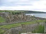
 View from guard house
 View of officer's house
.jpg.webp) Kinsale Harbour in 1714, before the Royal Navy moved their operations to Cork
Kinsale Harbour in 1714, before the Royal Navy moved their operations to Cork
See also
- Governor of Kinsale and Charles Fort
- Camden Fort Meagher - a similar coastal fortification defending Cork Harbour
References
- "Kinsale Tourism Guide - Charles Fort, Kinsale, County Cork, Ireland". CorkGuide.ie. Retrieved 29 October 2016.
- John Sprott Ryan (1836). The Life of William the Third. Grant and Bolton. p. 229.
Marlborough despatched a body of troops to summon Kinsale [..] he then retired his troops to two forrts, called the Old and New fort
- "South West - Charles Fort". Heritage Ireland (OPW). Archived from the original on 3 May 2015. Retrieved 29 October 2016.
- Thuillier, John (2014). Kinsale Harbour: A History. Cork: The Collins Press. p. 137. ISBN 978-1-84889-309-2.
- Pádraig Lenihan, ed. (2000). Conquest and Resistance: War in Seventeenth-Century Ireland. Brill. p. 167. ISBN 9789004117433.
- Jackman, Neil (29 May 2015). "The huge 17th century fort in Cork where a key battle between two English kings was fought". TheJournal.ie. The Journal. Retrieved 29 September 2023.
- "Charles Fort, County Cork". Buildings of Ireland. National Inventory of Architectural Heritage. Retrieved 29 October 2016.
- "Historic Houses and Castles - Charles Fort". Discover Ireland. Retrieved 29 October 2016.
- "A Brief History of Irish Lights". The Commissioners of Irish Lights. Archived from the original on 3 February 2007.
- "Charles Fort, County Cork". IrelandsEye. Retrieved 29 October 2016.
- Fallon, Linda (2007). Bradt City Guide Cork. Bradt Travel Guides. ISBN 978-1-84162-196-8.
- "Charles Fort & James Fort". DoChara.com. 29 November 2008. Retrieved 29 October 2016.
- "Visitors to Tourist Attractions 2007-2011" (PDF). Failte Ireland. October 2012. Retrieved 29 October 2016.
- "Press Release - OPW announces record visitor numbers to OPW Heritage Sites in 2015". Office of Public Works (OPW.ie). 14 March 2016.