Cəhriçay
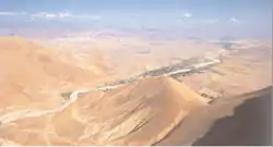
The Cəhriçay (Russian: Джагричай Dzhagrichay) is a river in the Babek District (Nakhchivan Autonomous Republic) in Azerbaijan. The river is 45 kilometres (28 mi) long and has a basin area of 442 square kilometres (171 sq mi). Its source is in the Daralayaz mountains at an elevation of 2,320 metres (7,610 ft). It is a right tributary of the Naxçıvançay, itself a tributary of the Aras. The water sources of the Cəhriçay are snow, rain and groundwater. The river is mostly used for irrigation.[1] It flows through the village Cəhri.
| Cəhriçay | |
|---|---|
 | |
| Location | |
| Country | Azerbaijan |
| Physical characteristics | |
| Mouth | Naxçıvançay |
• coordinates | 39.2901°N 45.4515°E |
| Length | 45 km (28 mi) |
| Basin size | 442 km2 (171 sq mi) |
| Basin features | |
| Progression | Naxçıvançay→ Aras→ Kura→ Caspian Sea |
References
- Nakhchivan Encyclopedia (volume 1, page 107)
This article is issued from Wikipedia. The text is licensed under Creative Commons - Attribution - Sharealike. Additional terms may apply for the media files.