Chepelare Peak
Chepelare Peak (Bulgarian: връх Чепеларе, romanized: vrah Chepelare, IPA: [ˈvrɤx t͡ʃɛpɛˈɫarɛ]) rises to approximately 900 m in the Friesland Ridge, Tangra Mountains, Livingston Island. The peak surmounts Charity Glacier to the west and Prespa Glacier to the southeast and is named after the Bulgarian town of Chepelare.
Location of Tangra Mountains on Livingston Island in the South Shetland Islands.

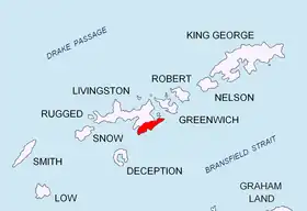
Topographic map of Livingston Island, Greenwich, Robert, Snow and Smith Islands.
Location
The peak is located at 62°43′18.3″S 60°15′04″W which is 700 m south-southwest of St. Methodius Peak, 1.07 km southeast of Tervel Peak and 850 m north of Shumen Peak. Bulgarian mapping in 2005 and 2009.
Maps
- L.L. Ivanov et al. Antarctica: Livingston Island and Greenwich Island, South Shetland Islands. Scale 1:100000 topographic map. Sofia: Antarctic Place-names Commission of Bulgaria, 2005.
- L.L. Ivanov. Antarctica: Livingston Island and Greenwich, Robert, Snow and Smith Islands. Scale 1:120000 topographic map. Troyan: Manfred Wörner Foundation, 2009. ISBN 978-954-92032-6-4
References
- Chepelare Peak. SCAR Composite Gazetteer of Antarctica
- Bulgarian Antarctic Gazetteer. Antarctic Place-names Commission. (details in Bulgarian, basic data in English)
External links
- Chepelare Peak. Copernix satellite image
This article includes information from the Antarctic Place-names Commission of Bulgaria which is used with permission.
This article is issued from Wikipedia. The text is licensed under Creative Commons - Attribution - Sharealike. Additional terms may apply for the media files.