Chiapas Highlands
The Chiapas Highlands, also known as the Central Highlands of Chiapas or Chiapas Plateau (Spanish: Los Altos de Chiapas), is a geographic, sociocultural and administrative region located in Chiapas, the southernmost state of Mexico.
| Chiapas Highlands | |
|---|---|
| Central Highlands of Chiapas Chiapas Plateau | |
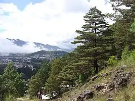 Chiapas Highlands above San Cristóbal de las Casas | |
| Highest point | |
| Elevation | 2,880 m (9,450 ft) |
| Coordinates | 16.7167°N 92.6167°W |
| Naming | |
| Native name | Los Altos de Chiapas (Spanish) |
| Geography | |
 Chiapas Highlands | |
| Country | Mexico |
| State | Chiapas |
Geography
The Chiapas Highlands are in the central part of the state of Chiapas. They are part of the Central American highlands, which run from the Isthmus of Tehuantepec in Mexico to central Nicaragua.[1] The Chiapas Highlands comprise a limestone mass with extrusive volcanic rocks at the highest peaks, covering over 11,000 km2. They extend 160 km along a northwest–southeast axis, and 70 km at the widest.[2] The elevation varies from 300 to 2,898 meters above the sea level.[3]
The northern and eastern slopes of the Central Highlands are drained by the Usumacinta River, which empties northwards into the Gulf of Mexico. The Chiapas Depression lies south of the Central Highlands. The Chiapas Depression and southern slopes of the Chiapas Highlands are drained by the Grijalva River, which also empties northwards into the Gulf of Mexico. The limestone of the plateau is easily eroded by water, creating a karst landscape with many sinkholes, sinkhole lakes, caverns, and underground drainage.
The Chiapas Depression separates the Central Highlands from the Sierra Madre de Chiapas, which runs east and west through the southern part of Chiapas and extending west into Oaxaca and eastwards into Guatemala and El Salvador. The Sierra Madre de Chiapas forms the divide between the basins of the Grijalva and Usumacinta rivers and those that drain southwards into the Pacific Ocean.[1]
San Cristóbal de las Casas is the largest city in the highlands. Other towns include Comitán and Ocosingo.
Climate
San Cristóbal de las Casas, a city in the Chiapas highlands has a mild subtropical highland climate (Köppen climate classification Cwb) moderated by its altitude.[4] The dry season, which runs from November to April is cool with a January average of 12.3 °C (54.1 °F). Owing to its altitude and the relative aridity of the dry season, San Cristóbal de las Casas has a fairly high diurnal temperature range and nighttime temperatures are cool. Extended periods of frosts are rare, occurring only 2–3 days per year in December to February. Humidity is high (around 78%), even during the winter months, and fog or mist is quite common during the winter months, occurring 13–17 days per month with fog. Usually, this clears off during the day. The wet season, which runs from May to October is warmer, with a June average of 17.0 °C (62.6 °F) and precipitation is significantly higher during these months. Fog is less common during this time. Average annual precipitation is 1,084.7 millimetres (42.7 in) most of it concentrated in the wet season. The wettest month recorded was September 1998 when 525.8 millimetres (20.7 in) of precipitation was recorded, and the wettest day recorded was on October 4, 2005 with105 millimetres (4.1 in). Extremes range from a low of −8.5 °C (16.7 °F) to 35.8 °C (96.4 °F).
Flora and fauna
The higher elevations are covered by pine forests, with Mexican yellow pine (Pinus oocarpa) and smooth-bark Mexican pine (Pinus pseudostrobus). Pine–oak forests include Mexican yellow pine and smooth-bark Mexican pine with Quercus peduncularis and other species of oaks.[5]
montane cloud forests are found on the windward north- and east-facing slopes with high year-round rainfall. Predominant trees include oaks, majagua (Trichospermum mexicanum), American sweetgum (Liquidambar styraciflua) and alder (Alnus sp.).[5]
Lower-elevation forests include areas of tropical evergreen forest, with big-leaf mahogany (Swietenia macrophylla), Spanish cedar (Cedrela odorata) and Santa Maria hardwood (Calophyllum brasiliense), and dry forests in the southwest, which lies in the mountains' drier rain shadow.[5]
Municipalities
The Chiapaneca regional government recognizes the highlands as a socioeconomic region called "altos Tsotsil-Tsetsal" that is formed by 17 municipalities. Culturally, the region is subdivided in Tsotsil and Tsetsal. Spanish is the main language spoken in San Cristobal, however in all of the rural municipalities the main language spoken is either Tsotsil or Tsetsal. In fact, Tsotsil is the lingua franca in the region and is spoken amongst many indigenous of other denominations and some Latinos.
Economy
The seasonal pattern of rain is ideal for the cultivation of maize and beans which are the staple food for most local indigenous people. However, at high elevations in Tierra Fria production only reaches subsistence levels. On the flanks of the highlands between an altitude of 4,000 and 5,500 ft coffee can be produced. Coffee constitutes a major crop and unlike beans and maize it is sold for cash.[6] Other cash crops are also produced within the region such as cabbage in Chamula or Mandarins in Tenejapa, but their importance is null compared with coffee.[7] Cattle and sheep are other commercial enterprises.[6][8]
Producers (usually indigenous) also face hardships when trying to commercialize their produce, as described by Brown[8] it is a usual practice for intermediaries also known as coyotes (usually ladinos) to charge producers a high fee to transport their harvest from their community to the cabezera municipal (head of county) or San Cristobal to be sold. In that same way, products sold directly in the communities tend to be more expensive than when sold in San Cristobal. As a result, some indigenous coffee producing communities have self organize in to coffee cooperatives offering an alternative to independent indigenous producers to commercialize their product.[8]
Marginalization
Economic activity in Los Altos is constrained by a high degree of marginalization. The region's total population is 601,190 distributed in 1,182 villages of which only two have more than 15,000 inhabitants. The vast majority of people live in communities with less than 2,500 inhabitants. In fact there are more than 900 communities with less than 500 inhabitants.[9] The largest population center is San Cristobal de las Casas with 158, 000 inhabitants. This city is the regional economic and political center of the region.[10] San Cristobal or 'Jovel' (in Tsotsil) was founded in 1528 as "Ciudad Real" by Spanish conquerors as the capital of the province and the headquarters of Hispanic control in the highlands. In colonial times the Chiapanecan region was a marginal territory due to its lack of precious metals and its long distance to the main commerce routes or the sea making it an unattractive region for Spanish conquers to settle in.[11] In Los Altos the social order was composed of extreme castes, the majority of the inhabitants were impoverished Indians while few Spanish concentrated the social and economic power.[11]
Ethnic segregation was the core of the economic system. Some[12] believe that this is an over-simplification of the situation as it pertains to San Cristobal de Las Casas and the surrounding Tsotsil communities, especially those in the Chamula region. Since colonial times and until recently the Los Altos indigenous population provided a steady flow of labor to other regions and to the non indigenous living within the region. San Cristobal was described as a "parasitic city that used its political, administrative, and religious powers to strip the Indians of the fruits of their labors."[11] The city was key in establishing an exploitation system in the region which exploited long term ethnic divisions between local indigenous populations (mostly Tsotsiles and Tseltales) and the historically dominant hispanic groups in chiapas: the ladinos (who had historically lived in Los Altos and in particular San Cristobal since colonial times) and mestizos (Hispianics originating from other parts of Chiapas or from elsewhere in Mexico). While it is certainly no longer a situation that can easily be characterized as "exploitation", those changes are fairly recent. Brown, (1993) talks extensively about the inequalities faced by indigenous people, inequalities that (as of 1993) still persisted despite various attempts by the Mexican government to help the indigenous groups in the region integrate socially and economically with modern Mexican society.
However, the 1995 Zapatista Rebellion marked a turning point in this regard as tensions that had simmered for decades finally boiled over, and members of the leftist armed resistance movement EZLN overran much of the area, seizing control of most of the Los Altos region including the city of San Cristóbal de las Casas. Remarkably, and for reasons which are as complex as everything else about the politics of Los Altos, it was a largely bloodless insurrection; within a week of the initial mobilization, a ceasefire was negotiated with the Mexican Army, a ceasefire which both sides continue to honor as of this edit, 2023. Many highland communities continue to publicly declare their support for the EZLN and operate with considerable autonomy in local matters, as agreed in 1995 and then reaffirmed over several more recent negotiations; federal forces operate military bases close to Zapatista strongholds in Los Altos (including one just a few miles outside of Altamirano, the de facto "capital' of the movement and home to several EZLN bases and military training facilities for armed Zapatista fighters).
However, law enforcement in the Zapatista areas is almost entirely the responsibility of local authorities; civil defense and law enforcement agencies such as Guardia Nacional and the Policia Estatal typically do not have a presence outside of major cities such as San Cristobal; this includes larger communities such as Altamirano where the support for Zapatista policies and seccessionist ideology is unwritten, or where the EZLN is not very popular due to people supporting different socialist-leaning groups or systems of local government based around ethnicity. These places will typically have a system of government that is much more decentralized than the rest of Mexico or modern republics such as the US; as do many other Tsotsil and Tseltal communities in the Los Altos region which are NOT known as being supporters of that rebellion. Typically, however, indigenous communities in Los Altos are far closer to true autonomy ("self government") than those in Canada and the US. They also compare favorably in this regard to most other parts of Mexico and other Latin American countries, with some notable exceptions.
As of 2023, if you travel along any of the common routes between San Cristobal, Altamirano, and Comitan / Las Margaritas, communities which officially support the movement announce this with large, colorful signage at the entrance or the offramp from the panamerican highway.
The legacy of this includes a remarkably local system of government; most of these places, and other communities which are not EZLN-affiliated but have adopted similar policies, are what a Westerner would call "hyperlocal". Each community will typically have its own legal code, which can vary significantly between towns that are often only a few miles apart; for example, some of these communities do not allow outsiders to enter, unless they have a specific reason to be there, while others actively court tourists and the majority are silent on the matter. Some places have banned alcohol and drugs (including marijuana), completely, with strict enforcement of these laws. Others, like the city of San Cristobal, has very little restriction on alcohol and has decriminalized all illegal drugs, for reasons that are not known for the policy remains unwritten - but even conservatives will tend to agree that there is an overall social benefit to doing so, in the current situation where the transnational drug cartels which move product north along the Panamerican highway have not taken over the city itself, and therefore it remains a much safer place for all residents than other places in Mexico that are situated along major smuggling routes. And despite the official guidance given to tourists about roadblocks and political instability in the Los Altos region, the reality is very different: the "roadblocks" between San Cristobal and Palenque are usually just tolls that are collected by communities when they need to fix the road. Even when the road is blocked for reasons of political protest, like the road to Comitan, it does not present any particular safety hazard to the foreigner - if your Spanish is good, they may even let you through, because you are obviously not part of whatever conflict is going on at the time, and there's no reason you should be inconvenienced.
Starting in the 1940s the Instituto Nacional Indigenista (INI) run a program aimed at "integrating" the indigenous people to the modern world. The public policy was known as indigenismo. Acculturation took place through the training of promotores -indigenous instructors- that taught Spanish, hygiene and cultural norms to indigenous communities. Another important component of the program was to introduce much needed infrastructure like roads, schools health clinics and commerce to the communities since as pointed out by Lewis,[10] during the 1950s modern infrastructure was virtually non existent outside of San Cristobal. Despite many difficulties and the use of controversial approaches, the program created a rudimentary highway system in which some of the communities are connected by all weather roads while most have access through dirt roads that are unusable during the rainy season or no road at all.[8][3] As a consequence bringing products to the communities can be a difficult task.
See also
References
- CEIEG (2011). Mapa s regionales. RegionV Tsotsil, Tsetsal. http://www.ceieg.chiapas.gob.mx/home/?page_id=4109
- CEIEG (2012). Regiones socioeconomicas y sus municipios. Retrieved on June 10, 2013 http://www.ceieg.chiapas.gob.mx/home/?p=8024
Notes
- The Editors of Encyclopaedia Britannica (2012). Chiapas Highlands. Encyclopedia Britannica. 27 February 2012. Accessed 27 September 2021.
- Ochoa Gaona, S. & Gonzalez Espinosa, M. (2000). Land use and deforestation in the highlands of Chiapas, Mexico. Applied Geography, 20(1), 17–42.
- CEIEG (2013). Informacion estadistica, Retrieved on March 25, 2013 http://www.ceieg.chiapas.gob.mx/home/?page_id=10703&maccion=15
- Kottek, M.; J. Grieser; C. Beck; B. Rudolf; F. Rubel (2006). "World Map of the Köppen-Geiger climate classification updated" (PDF). Meteorol. Z. 15 (3): 259–263. Bibcode:2006MetZe..15..259K. doi:10.1127/0941-2948/2006/0130. Retrieved January 18, 2013.
- Wiken, Ed, Francisco Jiménez Nava, and Glenn Griffith. 2011. North American Terrestrial Ecoregions—Level III. Commission for Environmental Cooperation, Montreal, Canada.
- Menegoni, L. (1990). Tuberculosis and health care in Highland Chiapas, Mexico: An ethnographic study. (Doctoral dissertation). Retrieved from ProQuest Dissertations and Theses. (Accession Order No.9123623).
- De La Torre, S. (2012). Food security in La Hormiga, Mexico. Report submitted to CSID, Arizona State University.
- Brown, P. (1993). The creation of a Community: Class and ethnic struggle in Pantelhó, Chiapas, Mexico. (Doctoral dissertation). Retrieved from ProQuest Dissertations and Theses. (Accession Order No.9409193).
- (CEIEG, 2011)
- Lewis, S.E. (2008). Mexico's National Indigenist Institute and the Negotiation of Applied Anthropology in Highland Chiapas, 1951–1954. Ethnohistory, 55(4), 609–632.
- Viqueira, J.P. (2004). Las causas de una rebelión India: Chiapas, 1712. In Viqueira, J.P. & Ruz, M.H. (comps.).Chiapas: los rumbos de otra historia.
- Martinez (2023, Personal Communication)