Chonhar Strait
The Chonhar Strait (Ukrainian: Чонгарська протока), sometimes spelled Chongar Strait[1] (Russian: Чонгарский пролив; Crimean Tatar: Çonğar boğazı), is a short, shallow, narrow strait in Ukraine, separating the eastern and western portions of the Syvash, the shallow lagoon system separating Crimea from the mainland east of the Isthmus of Perekop.
| Chonhar Strait Чонгарська протока | |
|---|---|
 | |
.jpg.webp) Chonhar Strait Чонгарська протока  Chonhar Strait Чонгарська протока  Chonhar Strait Чонгарська протока | |
| Coordinates | 45°59′12.0″N 34°33′07.0″E |
| Type | Strait |
| Basin countries | |
| Max. length | 80–150 m (260–490 ft) |
| Min. width | 300 m (980 ft) |
| Max. depth | 3 m (9.8 ft) |
Geography
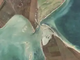
The Chonhar Strait separates Chonhar Peninsula in the north (on the mainland, and containing the village of Chonhar) from the Tup-Dzhankoi Peninsula in the south (in Crimea). The strait is about 300 metres (980 ft) long, varying in width from 80–150 metres (260–490 ft) and is less than 3 metres (9.8 ft) deep.[2] Two road bridges cross the strait. One carries the Ukrainian M18 highway, which is part of European route E105 running from northern Norway to Yalta. The old bridge, located further south, is abandoned. There is no railway bridge across the strait, but a rail bridge a few kilometres west at Syvash village (also on Chonhar Peninsula) is sometimes also called "Chonhar Bridge".
History
Russian Civil War
During the Russian Civil War, the Chonhar Strait was one avenue of attack during the Perekop-Chongar Operation in November 1920 and was crossed by the Soviet 30th Rifle Division. The operation resulted in the Soviet capture of Crimea and forced the final evacuation of Wrangel's White Army and the end of the Civil War in the south.[3]
Russo-Ukrainian War
Between 2014 and 2022, the Chonhar Strait formed part of the de facto border between mainland Ukraine and the Russian-annexed Crimean peninsula, and was militarized.[4][5] Around 22 June 2023, amidst the full-scale Russian invasion of Ukraine in which Russian forces had seized parts of southeast Ukraine bordering Crimea, Russian-installed occupation officials announced that Ukraine had damaged the highway bridge crossing the Chonhar Strait with one or more Storm Shadow missiles.[1][6][7] Russia quickly built a pontoon bridge.[8] Ukraine damaged the bridge again (along with the bridge of Henichesk Strait) with Storm Shadow missiles on 6 August 2023.[9][10]
References
- "Ukraine updates: Ukraine 'damages' key Crimea bridge". Retrieved 23 June 2023.
- Лист карты L-36-XXIII.
- "Perekop-Chongar Operation of 1920". The Free Dictionary. Retrieved October 3, 2014.
- Epaminondas (March 4, 2014). "Russian Army Digging on Chongar Strait: UK Telegraph (man on scene)". Infidel Blogger's Alliance. Retrieved October 3, 2014.
- "Photos: Conflict in Ukraine". Montreal Gazette. March 21, 2014. Retrieved October 3, 2014.
- "Ukraine updates: Ukraine 'damages' key Crimea bridge – DW – 06/22/2023". dw.com. Retrieved 2023-07-18.
- "IMAGO". www.imago-images.de. Retrieved 2023-07-18.
- "Satellite imagery shows new pontoon crossing under Chonhar Bridge after alleged Ukrainian strike". The Kyiv Independent. 2023-06-23. Retrieved 2023-07-18.
- Lister, Kostan Nechyporenko,Denis Lapin,Tim (2023-08-06). "Explosions hit road bridges between Crimea and occupied Ukraine". CNN. Retrieved 2023-10-02.
{{cite web}}: CS1 maint: multiple names: authors list (link) - "Ukraine knocks out two critical bridges used by Russia to supply southern troops from Crimea – ISW". english.nv.ua. Retrieved 2023-10-02.