Chorakhe Bua
Chorakhe Bua (Thai: จรเข้บัว, pronounced [t͡ɕɔ̄ː.rā.kʰêː būa̯]) is a neighbourhood in east Bangkok. It roughly occupies the area of the khwaeng (subdistrict) of the same name in Lat Phrao district.
Chorakhe Bua
จรเข้บัว | |
|---|---|
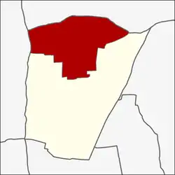 Location in Lat Phrao district | |
| Coordinates: 13°50′19.3″N 100°36′23.1″E | |
| Country | |
| Province | Bangkok |
| Khet | Lat Phrao |
| Area | |
| • Total | 7.055 km2 (2.724 sq mi) |
| Population (2021) | |
| • Total | 26,467 |
| • Density | 3,751.52/km2 (9,716.4/sq mi) |
| Time zone | UTC+7 (ICT) |
| Postal code | 10400 |
| TIS 1099 | 103802 |
History
Originally, the area of Chorakhe Bua was very spacious. It covers parts of Bang Kapi, Bang Khen and Khan Na Yao Districts today. In 1997, two parts of Chorakhe Bua switched to Bang Khen District.
Geography
Chorakhe Bua is the northern part of the district. Its adjoining subdistricts, clockwise from the north, are Anusawari and Tha Raeng in Bang Khen District, Lat Phrao in its district, and Sena Nikhom in Chatuchak District.[2]
Transportation
- Lat Pla Khao Road
- Prasoet Manukit Road (Highway 351)[2]
References
- กองยุทธศาสตร์บริหารจัดการ. สำนักยุทธศาสตร์และประเมินผล. กรุงเทพมหานคร. "จำนวนประชากร พื้นที่ ความหนาแน่น จำนวนบ้าน จำแนกตามแขวง ในเขตกรุงเทพมหานคร 2563." สถิติกรุงเทพมหานครประจำปี 2563.
- "แขวงจรเข้บัว เขตลาดพร้าว กรุงเทพมหานคร" [Chorakhae Bua Subdistrict, Lat Phrao District, Bangkok]. R01.ldd.go.th/ (in Thai).
This article is issued from Wikipedia. The text is licensed under Creative Commons - Attribution - Sharealike. Additional terms may apply for the media files.