Circular Head Council
Circular Head Council is a local government body in Tasmania covering the far north-west mainland. It is classified as a rural local government area with a population of 8,066,[1] and its major towns and localities include Arthur River, Marrawah and Stanley, with Smithton being the largest and principal town. The origin of the name “Circular Head” is unknown.
| Circular Head Council Tasmania | |||||||||||||||
|---|---|---|---|---|---|---|---|---|---|---|---|---|---|---|---|
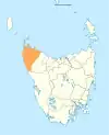
Map showing the Circular Head local government area. | |||||||||||||||
| Coordinates | 41.0673°S 145.0122°E | ||||||||||||||
| Population | 8,117 (2018)[1] | ||||||||||||||
| • Density | 1.65721/km2 (4.2921/sq mi) | ||||||||||||||
| Established | 1 January 1907[2] | ||||||||||||||
| Area | 4,898 km2 (1,891.1 sq mi)[1] | ||||||||||||||
| Mayor | Gerard Blizzard | ||||||||||||||
| Council seat | Smithton | ||||||||||||||
| Region | Smithton and Stanley area | ||||||||||||||
| State electorate(s) | Braddon | ||||||||||||||
| Federal division(s) | Braddon | ||||||||||||||
| Website | Circular Head Council | ||||||||||||||
| |||||||||||||||
History and attributes
Circular Head was established on 1 January 1907, the boundaries were altered in 1993 as part of a reorganisation.[2] The region includes the smaller islands immediately off the north-west tip of the state including Robbins Island, Hunter Island and Three Hummock Island.
Circular Head is classified as rural, agricultural and large (RAL) under the Australian Classification of Local Governments.[3]
Government
| Name | Position[4] | Party affiliation | |
|---|---|---|---|
| Gerard Blizzard | Mayor/Councillor | Independent | |
| Anette Dawes | Deputy Mayor/Councillor | Independent | |
| Sally Collins | Councillor | Independent | |
| Mark Dabner | Councillor | Independent | |
| Rodney Flowers | Councillor | Jacqui Lambie Network[5] | |
| Steve Pilkington | Councillor | Independent | |
| John Oldaker | Councillor | Independent | |
| Ashley Popowski | Councillor | Independent | |
| Tony Hine | Councillor | Independent | |
Localities
| Locality | Population (2011 census)[6] | Reason |
|---|---|---|
| Woolnorth | Incl. in Arthur River | |
| West Montagu | Incl. in Montagu | |
| Montagu | 327 | Includes West Montagu, Broadmeadows, Mella, Sorpus |
| Scopus | Incl. in Montagu | |
| Hunter Island | Incl. in Arthur River | |
| Three Hummock Island | Incl. in Arthur River | |
| Trefoil Island | Incl. in Arthur River | |
| Walker Island | Incl. in Arthur River | |
| Robbins Island | Incl. in Arthur River | |
| Kangaroo Island | Incl. in Arthur River | |
| Perkins Island | Incl. in Arthur River | |
| Mella | Incl. in Montagu | |
| Smithton | 3,935 | |
| Broadmeadows | Incl. in Montagu | |
| Stanley | 481 | |
| Wiltshire | Incl. in Forest | |
| Black River | Incl. in Mawbanna | |
| Cowrie Point | Incl. in Mawbanna | |
| Port Latta | Incl. in Mawbanna | |
| Crayfish Creek | Incl. in Hellyer | |
| Edgcumbe Beach | Incl. in Hellyer | |
| Rocky Cape | 216 | |
| Montumana | Incl. in Mawbanna | |
| Mawbanna | 208 | Includes Montumana, Port Latta, Cowrtie Point, Black River |
| Forest | 590 | Includes Wiltshire |
| South Forest | Incl. in Mengha | |
| Mengha | 300 | Includes South Forest, Alcombie |
| Scotchtown | 303 | Includes Edith Creek |
| Irishtown | 287 | |
| Alcomie | Incl. in Mengha | |
| Lileah | Incl. in Trowutta | |
| Nabageena | Incl. in Trowutta | |
| Edith Creek | Incl. in Scotchtown | |
| Roger River | Incl. in Trowutta | |
| Detention | Incl. in Rocky Cape | |
| Hellyer | 302 | Includes Crayfish Creek, Edgcumbe Beach |
| West Coast | 13 | Includes Temma |
| Christmas Hills | Incl. in Redpa | |
| Brittons Swamp | Incl. in Redpa | |
| Togari | Incl. in Redpa | |
| Redpa | 343 | Includes Togari, Brittons Swamp, Christmas Hills |
| Marrawah | Incl. in Arthur River | |
| Arthur River | 371 | Includes Woolnorth, Hunter Island, Three Hammock Island, Trefoil Island, Walker Island, Robbins Island, Kangaroo Island, Marrawah, Nelson Bay |
| Nelson Bay | Incl. in Arthur River | |
| Temma | Incl. in Westcoast | |
| Trowutta | 297 | Includes Lileah, Nabageena, Roger River |
| Total | 7,973 | |
| 4 | Variance | |
| Local government total | 7,977 | Gazetted Central Coast local government area |
Not in above list
References
- "3218.0 – Regional Population Growth, Australia, 2017-18: Population Estimates by Local Government Area (ASGS 2018), 2017 to 2018". Australian Bureau of Statistics. Australian Bureau of Statistics. 27 March 2019. Retrieved 25 October 2019. Estimated resident population, 30 June 2018.
- "Agency Details: Circular Head". search.archives.tas.gov.au. Tasmanian Government. Retrieved 11 June 2018.
- "Local government national report 2014-2015". regional.gov.au. Australian Government. Retrieved 8 June 2018.
- "Councillors - Circular Head Council". circularhead.tas.gov.au/. Circular Head Council. Retrieved 1 August 2021.
- Augustine, Judy. "TASMANIA VOTES: Your ultimate guide to local government elections". The Mercury.
- Australian Bureau of Statistics. "2011 Census QuickStats". Retrieved 9 April 2016.
External links
- Circular Head Council official website
- Local Government Association Tasmania
- Tasmanian Electoral Commission - local government