Clarie Coast
Clarie Coast, called Wilkes Coast by Australia, (66°30′S 133°0′E) is that portion of the coast of Wilkes Land lying between Cape Morse, at 130°10′E, and Pourquoi Pas Point, at 136°11′E. It was discovered in January 1840 by Captain Jules Dumont d'Urville, who recognized the existence of land lying south of the ice cliffs to which he applied the name Côte de Clarie, after the wife (Claire-Fortunée Roze) of Charles Jacquinot, the captain of his second ship, the Zélée.

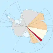
Location of Clarie Coast (red) in Wilkes Land, Australian Antarctic Territory.
It was also spotted by the US Exploring Expedition in Feb. 1840.[1]
References
- Stanton, William (1975). The Great United States Exploring Expedition. Berkeley: University of California Press. pp. 175. ISBN 0520025571.
 This article incorporates public domain material from "Clarie Coast". Geographic Names Information System. United States Geological Survey.
This article is issued from Wikipedia. The text is licensed under Creative Commons - Attribution - Sharealike. Additional terms may apply for the media files.