California bikeway classifications
California bikeway classifications are standards for identifying the level of travel efficiency and human protection offered by the various bike routes in the state. Traffic engineers use the designations for route planning.
| Bikeway class | Photo | Common name | CalTrans definition | Further info | Examples |
|---|---|---|---|---|---|
| Class I |  | BIKE PATH | “Bike paths should offer opportunities not provided by the road system. They can either provide a recreational opportunity, or in some instances, can serve as direct high-speed commute routes if cross flow by motor vehicles and pedestrian conflicts can be minimized. The most common applications are along rivers, ocean fronts, canals, utility right of way, abandoned railroad right of way, within school campuses, or within and between parks. Another common application of Class I facilities is to close gaps to bicycle travel caused by construction of freeways or because of the existence of natural barriers (rivers, mountains, etc.).”[1] | “off-roadway bike paths or bike trails” [2] | Coyote Creek Trail, Ballona Creek Bike Path |
| Class II | 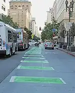 | BIKE LANE | “Bike lanes are established along streets in corridors where there is significant bicycle demand, and where there are distinct needs that can be served by them... Bike lanes are intended to delineate the right of way assigned to bicyclists and motorists and to provide for more predictable movements by each.”[1] | “on-roadway, separated (striped) bike lanes”[2] | |
| Class III | 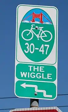 | BIKE ROUTE | “Bike routes are shared facilities which serve either to: (a) Provide continuity to other bicycle facilities (usually Class II bikeways) or (b) Designate preferred routes through high demand corridors. Normally, bike routes are shared with motor vehicles. The use of sidewalks as Class III bikeways is strongly discouraged.“[1] | “on-roadway, signed (but not separated) bike lanes[2] - Sharrows | The Wiggle |
| Class IV | 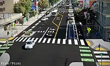 | SEPARATED BIKEWAY | “A bikeway for the exclusive use of bicycles and includes a separation required between the separated bikeway and the through vehicular traffic. The separation may include, but is not limited to, grade separation, flexible posts, inflexible posts, inflexible barriers, or on-street parking.”[1] | Elenda Bikeway, Culver City; Venice Blvd., Mar Vista, Los Angeles |
References
- "CalTrans Highway Design Manual. Chapter 1000 – Bicycle Transportation Design" (PDF).
- Brundige, Don; Brundige, Sharron (2007). Cycling Los Angeles (2nd ed.). San Diego, Calif.: Sunbelt Publications. p. xxiv. ISBN 978-0-932653-81-9.
This article is issued from Wikipedia. The text is licensed under Creative Commons - Attribution - Sharealike. Additional terms may apply for the media files.