Coal Creek, Jefferson County, Colorado
Coal Creek, commonly known as Coal Creek Canyon, is a census-designated place (CDP) located in and governed by Jefferson, Boulder, and Gilpin counties in Colorado, United States, but primarily Jefferson County. The population of the Coal Creek CDP was 2,494 at the United States Census 2020.[3] The Golden post office (Zip code 80403) serves the area.[4]
Coal Creek, Colorado | |
|---|---|
 "Downtown" Coal Creek Canyon. | |
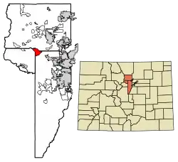 | |
 Coal Creek Location of the Coal Creek CDP in the United States. | |
| Coordinates: 39°54′26″N 105°22′48″W[1] | |
| Country | |
| State | |
| Counties | Jefferson County Boulder County, Gilpin County |
| Government | |
| • Type | unincorporated community |
| Area | |
| • Total | 9.404 sq mi (24.355 km2) |
| • Land | 9.388 sq mi (24.316 km2) |
| • Water | 0.015 sq mi (0.039 km2) |
| Elevation | 8,753 ft (2,668 m) |
| Population | |
| • Total | 2,494 |
| • Density | 270/sq mi (100/km2) |
| Time zone | UTC-7 (MST) |
| • Summer (DST) | UTC-6 (MDT) |
| ZIP Code[4] | Golden 80403 |
| Area codes | 303 & 720 |
| GNIS feature[2] | Coal Creek CDP |
Geography
The Coal Creek CDP has an area of 6,018 acres (24.355 km2), including 9.6 acres (0.039 km2) of water.[1]
Climate
According to the Köppen Climate Classification system, Coal Creek has a warm-summer humid continental climate, abbreviated "BSk" on climate maps, but closely borders on an oceanic climate (Cfb).
| Climate data for Coal Creek Canyon, Colorado, 1991–2020 normals, extremes 1984–2019 | |||||||||||||
|---|---|---|---|---|---|---|---|---|---|---|---|---|---|
| Month | Jan | Feb | Mar | Apr | May | Jun | Jul | Aug | Sep | Oct | Nov | Dec | Year |
| Record high °F (°C) | 60 (16) |
58 (14) |
66 (19) |
73 (23) |
81 (27) |
88 (31) |
89 (32) |
87 (31) |
84 (29) |
75 (24) |
67 (19) |
60 (16) |
89 (32) |
| Mean maximum °F (°C) | 51.5 (10.8) |
51.4 (10.8) |
58.3 (14.6) |
63.9 (17.7) |
71.7 (22.1) |
80.5 (26.9) |
83.2 (28.4) |
81.0 (27.2) |
76.9 (24.9) |
68.7 (20.4) |
58.3 (14.6) |
51.6 (10.9) |
84.4 (29.1) |
| Average high °F (°C) | 33.4 (0.8) |
34.2 (1.2) |
41.2 (5.1) |
45.9 (7.7) |
55.3 (12.9) |
66.7 (19.3) |
73.0 (22.8) |
71.2 (21.8) |
64.3 (17.9) |
51.8 (11.0) |
40.9 (4.9) |
33.2 (0.7) |
50.9 (10.5) |
| Daily mean °F (°C) | 24.5 (−4.2) |
24.4 (−4.2) |
30.7 (−0.7) |
35.2 (1.8) |
44.0 (6.7) |
54.0 (12.2) |
60.3 (15.7) |
58.6 (14.8) |
51.7 (10.9) |
40.8 (4.9) |
31.0 (−0.6) |
24.0 (−4.4) |
39.9 (4.4) |
| Average low °F (°C) | 15.6 (−9.1) |
14.7 (−9.6) |
20.2 (−6.6) |
24.4 (−4.2) |
32.6 (0.3) |
41.2 (5.1) |
47.5 (8.6) |
46.1 (7.8) |
39.2 (4.0) |
29.8 (−1.2) |
21.1 (−6.1) |
14.8 (−9.6) |
28.9 (−1.7) |
| Mean minimum °F (°C) | −6.8 (−21.6) |
−8.4 (−22.4) |
−0.4 (−18.0) |
7.5 (−13.6) |
19.3 (−7.1) |
31.1 (−0.5) |
39.1 (3.9) |
36.7 (2.6) |
24.8 (−4.0) |
12.4 (−10.9) |
0.9 (−17.3) |
−8.3 (−22.4) |
−15.5 (−26.4) |
| Record low °F (°C) | −24 (−31) |
−36 (−38) |
−18 (−28) |
−10 (−23) |
4 (−16) |
26 (−3) |
33 (1) |
30 (−1) |
3 (−16) |
−11 (−24) |
−17 (−27) |
−30 (−34) |
−36 (−38) |
| Average precipitation inches (mm) | 1.00 (25) |
1.32 (34) |
2.68 (68) |
3.79 (96) |
3.24 (82) |
2.19 (56) |
2.89 (73) |
2.84 (72) |
1.86 (47) |
1.66 (42) |
1.23 (31) |
1.13 (29) |
25.83 (655) |
| Average snowfall inches (cm) | 17.4 (44) |
23.2 (59) |
35.6 (90) |
42.0 (107) |
16.6 (42) |
0.9 (2.3) |
0.0 (0.0) |
0.0 (0.0) |
2.7 (6.9) |
16.1 (41) |
18.4 (47) |
21.8 (55) |
194.7 (494.2) |
| Average precipitation days (≥ 0.01 in) | 9.6 | 10.4 | 11.2 | 13.6 | 13.6 | 12.2 | 14.8 | 15.4 | 9.8 | 8.1 | 8.1 | 9.0 | 135.8 |
| Average snowy days (≥ 0.1 in) | 10.5 | 11.3 | 12.1 | 12.7 | 6.9 | 0.9 | 0.0 | 0.0 | 1.2 | 6.2 | 8.4 | 10.0 | 80.2 |
| Source 1: NOAA[5] | |||||||||||||
| Source 2: National Weather Service (mean maxima and minima 1984–2019)[6] | |||||||||||||
Demographics
The United States Census Bureau initially defined the Coal Creek CDP for the United States Census 2000.
| Year | Pop. | ±% |
|---|---|---|
| 2000 | 2,323 | — |
| 2010 | 2,400 | +3.3% |
| 2020 | 2,494 | +3.9% |
| Source: United States Census Bureau | ||
References
- "State of Colorado Census Designated Places - BAS20 - Data as of January 1, 2020". United States Census Bureau. Retrieved December 17, 2020.
- "U.S. Board on Geographic Names: Domestic Names". United States Geological Survey. Retrieved December 17, 2020.
- United States Census Bureau. "Coal Creek CDP, Colorado". Retrieved April 10, 2023.
- "Zip Code 80403 Map and Profile". zipdatamaps.com. 2020. Retrieved December 20, 2020.
- "U.S. Climate Normals Quick Access". National Oceanic and Atmospheric Administration. Retrieved August 8, 2022.
- "NOAA Online Weather Data". National Weather Service. Retrieved August 8, 2022.
External links
- Coal Creek Canyon @ UncoverColorado.com
- Coal Creek Canyon Improvement Association
- Canyon Cares of Coal Creek Canyon
- Coal Creek Canyon Fire Protection District
- Coal Creek Canyon Park and Recreation District
- Coal Creek Canyon Mountain Messenger
Municipalities and communities of Jefferson County, Colorado, United States | ||
|---|---|---|
| Cities |  Map of Colorado highlighting Jefferson County | |
| Towns | ||
| CDPs | ||
| Unincorporated communities | ||
| Ghost towns | ||
| Footnotes | ‡This populated place also has portions in an adjacent county or counties | |
Municipalities and communities of Boulder County, Colorado, United States | ||
|---|---|---|
| Cities | 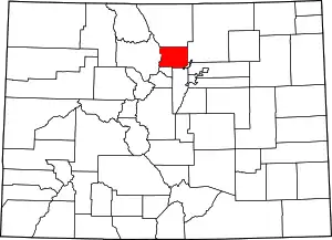 Map of Colorado highlighting Boulder County | |
| Towns | ||
| CDPs | ||
| Unincorporated communities | ||
| Ghost town | ||
| Footnotes | ‡This populated place also has portions in an adjacent county or counties | |
Municipalities and communities of Gilpin County, Colorado, United States | ||
|---|---|---|
| Cities |  Map of Colorado highlighting Gilpin County | |
| CDPs | ||
| Unincorporated communities | ||
| Footnotes | ‡This populated place also has portions in an adjacent county or counties | |