Ostrobothnia (region)
Ostrobothnia (Swedish: Österbotten; Finnish: Pohjanmaa) is a region in western Finland. It borders the regions of Central Ostrobothnia, South Ostrobothnia, and Satakunta. It is one of four regions considered modern-day Ostrobothnia, hence it is also referred to as Coastal Ostrobothnia to avoid confusion.
Ostrobothnia
| |
|---|---|
| Region of Ostrobothnia Landskapet Österbotten Pohjanmaan maakunta | |
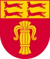 Coat of arms | |
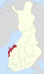 Ostrobothnia on a map of Finland | |
| Country | Finland |
| Historical province | Ostrobothnia |
| Capital | Vaasa |
| Area | |
| • Total | 7,932.36 km2 (3,062.70 sq mi) |
| Population (2019) | |
| • Total | 180,445 |
| • Density | 23/km2 (59/sq mi) |
| Time zone | UTC+2 (EET) |
| • Summer (DST) | UTC+3 (EEST) |
| ISO 3166 code | FI-12 |
| NUTS | 195 |
| Regional bird | Common swift (Apus apus) |
| Regional fish | Common whitefish (Coregonus lavaretus) |
| Regional flower | European meadowsweet (Filipendula ulmaria) |
| Website | osterbotten.fi |
Ostrobothnia is one of two Finnish regions with a Swedish-speaking majority (the other being the constitutionally monolingual province of Åland); Swedish-speakers make up 51.2% of the total population.[1] The region contains thirteen bilingual municipalities and one that is exclusively Finnish-speaking. The capital of Vaasa is predominantly inhabited by Finnish speakers, whereas smaller towns and rural areas are generally dominated by the Swedish language. The three municipalities with the largest number of Swedish speakers are Korsholm, Jakobstad and Pedersöre.
Geographically, Ostrobothnia has little topographical relief, because it is mostly former seafloor brought to surface by post-glacial rebound and the accumulation of alluvial sediment. Ostrobothnia has both vast expanses of cultivated fields (lakeus) as in Southern Ostrobothnia, and the archipelago of Kvarken (Finnish: Merenkurkku). Glacial transport has deposited large quantities of rocks in the area.[2] Like elsewhere in Pohjanmaa, rivers are a prominent part of the landscape. The major rivers that discharge into the Gulf of Bothnia in Ostrobothnia are Kyrönjoki, Lapuanjoki and Ähtävänjoki.
Kaskinen, a coastal town located in the southern part of the region, is the smallest town in Finland in terms of both area and population.[3]
Name and symbols
Prior to the officialization of the names of the Finnish regions, Ostrobothnia was also known as Vasa kustregionen in Swedish and Vaasan rannikkoseutu in Finnish, both of which translate into "[the] coastal region of Vaasa". The Institute for the Languages of Finland recommended that the region be named Kustösterbotten in Swedish and Rannikko-Pohjanmaa in Finnish, meaning "coastal Ostrobothnia" in English. However, upon the confirmation of the names of the Finnish regions on 26 February 1998, the current name of the region was officialized instead, according to the wishes of the regional government. The central government cited the Swedish language's prevalence in the region, as well as the lack of a common consensus on an alternative name the reasons for its decision.[4] In local circles or communities, Ostrobothnia is often referred to as "Pampas". The word derives from the similarities in the flat landscape with the Pampas area in South America.[5]
The regional tree is the black alder (Alnus glutinosa), the regional mammal is the common elk (Alces alces), the regional stone is Vaasa granite and the regional song is "The march of Vaasa" (Swedish: Vasamarschen, Finnish: Vaasan marssi).
Coat of arms
Gules, a sheaf Or; on chief countercharged four ermines 2+2 courant.
The sprouting wheatsheaf is a symbol of the Royal House of Vasa; a Vasa king established the city of Vaasa, the capital of the region. The running stoats are a symbol of Ostrobothnia.
Municipalities and languages
Language numbers
Language numbers for Ostrobothnia from 1990 to 2020:[6]
| Year | Swedish | % | Finnish | % | Russian | % | Other | % | Total |
|---|---|---|---|---|---|---|---|---|---|
| 1990 | 92,827 | 55.55% | 73,648 | 44.07% | 46 | 0.03% | 587 | 0.35% | 167,108 |
| 1995 | 92,372 | 54.69% | 74,723 | 43.98% | 190 | 0.11% | 1,603 | 0.95% | 168,888 |
| 2000 | 90,778 | 54.01% | 74,780 | 44.25% | 336 | 0.2% | 2,182 | 1.3% | 168,077 |
| 2005 | 90,083 | 53.44% | 74,597 | 44.25% | 436 | 0.26% | 3,903 | 2.06% | 168,583 |
| 2010 | 90,375 | 52.25% | 75,542 | 43.67% | 650 | 0.38% | 6,414 | 3.71% | 172,981 |
| 2015 | 90,083 | 50.92% | 76,156 | 43.05% | 917 | 0.52% | 9,738 | 5.5% | 176,894 |
| 2020 | 89,085 | 50.67% | 73,610 | 41.87% | 975 | 0.55% | 12,146 | 6.91% | 175,816 |
The region of Ostrobothnia is made up of 14 municipalities, of which six have town status (marked in bold), and the links are only in the majority language names.
| Name in Finnish |
Name in Swedish |
Population[7] | Swedish Speakers[8] |
Finnish Speakers[8] |
Sub-Region |
|---|---|---|---|---|---|
| Pietarsaari | Jakobstad | 19,401 | 55.3% | 32.4% | Jakobstad |
| Kaskinen | Kaskö | 1,217 | 26.9% | 59.3% | Sydösterbotten |
| Mustasaari | Korsholm | 19,759 | 68.6% | 28.4% | Vaasa |
| Korsnäs | Korsnäs | 2,009 | 84.3% | 3.8% | Vaasa |
| Kristiinankaupunki | Kristinestad | 6,200 | 53.7% | 41.3% | Sydösterbotten |
| Kruunupyy | Kronoby | 6,372 | 76.5% | 19.2% | Jakobstad |
| Laihia | Laihela | 7,714 | 1.2% | 97.1% | Kyrönmaa |
| Luoto | Larsmo | 5,849 | 92.1% | 5.3% | Jakobstad |
| Maalahti | Malax | 5,475 | 85.3% | 9.6% | Vaasa |
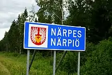
| Närpiö | Närpes | 9,595 | 75.3% | 5.2% | Sydösterbotten |
| Uusikaarlepyy | Nykarleby | 7,490 | 84.8% | 6.5% | Jakobstad |
| Pedersören kunta | Pedersöre | 11,202 | 88.6% | 8.3% | Jakobstad |
| Vaasa | Vasa | 68,580 | 23.4% | 66.2% | Vaasa |
| Vöyri | Vörå | [7] | 0% | 0% | Vaasa |
Climate
Ostrobothnia is located in the borderlands between the humid continental and subarctic climates (Köppen Dfb/Dfc). Its winters are moderated by prevailing westerly winds from the mild North Atlantic Current travelling across Norway, Sweden and the Bay of Bothnia. Although the sea tends to easily freeze over in winter during prolonged spells of cold weather due to the low salinity, winters seldom get severely cold.
In general during latter decades, the southern Bothnia Bay coastlines of central Norrland in Sweden across the strait and Ostrobothnia mostly range from slightly above 20 °C (68 °F) average highs in summer to about −3 °C (27 °F) highs and −10 °C (14 °F) lows in winter. Due to the vastness of the region from north to south, this will vary by a bit from one place to another depending on latitude.
Precipitation is quite variable but is enough to build up a reliable snowpack all through the region during winter months. In summer, Ostrobothnia experiences perpetual civil twilight due to its high latitude with the sun angle never falling below -3° at summer solstice in Vaasa and -2° in Jakobstad.[9][10] During that time of the year, daylight remains bright enough to permit daytime outdoor activities without artificial lighting especially under clear skies. As a result, days are short during winter although all areas of Ostrobothnia are far south of the Arctic Circle.
References
- Väestö iän ja sukupuolen mukaan alueittain 31.12.2008. Tilastokeskus: demography.
- "Aika, kallioperä ja jääkaudet » Merenkurkun saaristo". www.merenkurkku.fi. Retrieved 15 April 2018.
- "Island town | Visit Kaskinen". visitkaskinen.fi.
- "Valtioneuvosto nimesi Suomen maakunnat". The Finnish Ministry of Internal Affairs (in Finnish). 26 February 1998. Archived from the original on 24 May 2011. Retrieved 22 September 2020.
- Lång, Fredrik. "Författarnas Österbotten: Pampas eller Plattlandet" (PDF) (in Swedish). KulturÖsterbotten. Retrieved December 3, 2021.
- "11rl -- Language according to age and sex by region, 1990-2022". Statistics Finland. Retrieved 7 July 2023.
- "Finland's preliminary population figure was 5,587,841 at the end of August 2023". StatFin. Statistics Finland. Retrieved 30 September 2023.
- "Demographic Structure by area as of 31 December 2022". Statistics Finland's PX-Web databases. Statistics Finland. Retrieved 6 September 2023.
- "Sunrise and sunset times in Vaasan Lääni, June 2021". Timeanddate.com. Retrieved 9 January 2021.
- "Sunrise and sunset times in Jakobstad, June". Timeanddate.com. Retrieved 9 January 2021.