Coastal Venezuelan mangroves
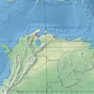
The Coastal Venezuelan mangroves ecoregion (WWF ID: NT1408) covers the salt-water mangrove forests along the Caribbean Sea and Atlantic Ocean coast of Venezuela, from Cocinetas Basin (on the western border with Colombia) to the edge of the Caño Manamo River and the Orinoco Delta in the east. It is one of the largest mangrove ecoregions in South America, with an area of 5,698 km2, and stretching across over 400 km of Venezuelan coastline.[1][2][3]
| Coastal Venezuelan mangroves | |
|---|---|
 | |
 Ecoregion territory (in red) | |
| Ecology | |
| Realm | Neotropic |
| Biome | Mangroves |
| Geography | |
| Area | 5,698 km2 (2,200 sq mi) |
| Country | Venezuela |
| Coordinates | 10.88°N 68.28°W |
Location and description
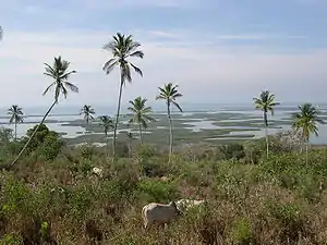
Mangrove forests line about one-fourth of the coast of Venezuela. Each individual site is relatively small, the majority being under 40 km2. The sites on the western, Caribbean, coast are drier and often have a savanna-like character. The eastern sites, on the Atlantic Ocean coast from the Gulf of Paria to the western edge of the Orinoco Delta, is wetter with precipitation up to 2,000 mm/year. There are small islands offshore with mangrove stands also.[3]
Mangrove sites vary in character by surrounding topography. Some form on the margins of gulfs or lagoons - such as the Gulf of Venezuela in the west and the Gulf of Paria in the east. Others form at the mouths of rivers - such as the El Limón River in the west, the Neverí River through Barcelona, the Manzanares River near Cumaná, and the San Juan River in the east. Small offshore islands often have mangrove areas, as do some lowland coastal areas.[1]
Climate
The climate of the ecoregion is Tropical savanna climate - dry winter (Köppen climate classification (Aw)). This climate is characterized by relatively even temperatures throughout the year, and a pronounced dry season. The driest month has less than 60 mm of precipitation, and is drier than the average month.[4][5] Precipitation averages from under 200 mm/year in the drier western areas, to over 1,600 mm/year in the east.[1]
Flora and fauna
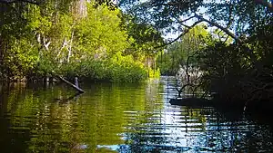
The most common tree species are red mangrove (Rhizophora mangle), black mangrove (Avicennia germinans) and white mangrove (Laguncularia racemosa). An additional species, the buttonwood mangrove (Conocarpus erectus), while not a true mangrove species, is found in the more arid areas. Associated vegetation includes thorn scrub woodlands, coastal evergreen trees, ferns (Acrostichum aureum) and mallows of genus Malvaceae, such as coastal hibiscus Hibiscus tiliaceus.[1]

Protected areas
Significant protected areas in the ecoregion include:
References
- "Coastal Venezuelan mangroves". World Wildlife Federation. Retrieved November 20, 2020.
- "Map of Ecoregions 2017". Resolve, using WWF data. Retrieved November 20, 2020.
- "Coastal Venezuelan mangroves". The Encyclopedia of Earth. Retrieved November 20, 2020.
- Kottek, M., J. Grieser, C. Beck, B. Rudolf, and F. Rubel, 2006. "World Map of Koppen-Geiger Climate Classification Updated" (PDF). Gebrüder Borntraeger 2006. Retrieved September 14, 2019.
{{cite web}}: CS1 maint: multiple names: authors list (link) - "Dataset - Koppen climate classifications". World Bank. Retrieved September 14, 2019.