Hustadvika (municipality)
Hustadvika is a municipality in Møre og Romsdal county, Norway. It is located in the traditional districts of Nordmøre and Romsdal. The administrative centre of the municipality is the village of Elnesvågen. Other villages in the municipality include Hustad, Bud, Tornes, Sylte, Malme, Aureosen, Eide, Lyngstad, Vevang, and Visnes.
Hustadvika kommune | |
|---|---|
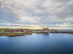 View of a hotel on the Hustadvika shoreline | |
 Coat of arms  Møre og Romsdal within Norway | |
 Hustadvika within Møre og Romsdal | |
| Coordinates: 62.916796°N 7.227630°E | |
| Country | Norway |
| County | Møre og Romsdal |
| District | Nordmøre |
| Established | 1 Jan 2020 |
| • Preceded by | Eide and Fræna |
| Administrative centre | Elnesvågen |
| Government | |
| • Mayor (2020) | Tove Henøen (Sp) |
| Area | |
| • Total | 521.93 km2 (201.52 sq mi) |
| • Land | 507.72 km2 (196.03 sq mi) |
| • Water | 14.21 km2 (5.49 sq mi) 2.7% |
| • Rank | #203 in Norway |
| Population (2022) | |
| • Total | 13,287 |
| • Rank | #90 in Norway |
| • Density | 26.2/km2 (68/sq mi) |
| • Change (10 years) | |
| Demonym | Hustadværing[1] |
| Official language | |
| • Norwegian form | Neutral |
| Time zone | UTC+01:00 (CET) |
| • Summer (DST) | UTC+02:00 (CEST) |
| ISO 3166 code | NO-1579 |
| Website | Official website |
The 522-square-kilometre (202 sq mi) municipality is the 203rd largest by area out of the 356 municipalities in Norway. Hustadvika is the 90th most populous municipality in Norway with a population of 13,287. The municipality's population density is 26.2 inhabitants per square kilometre (68/sq mi) and its population has increased by 2.8% over the previous 10-year period.[3][4]
General information
On 1 January 2020, the neighboring municipalities of Eide (population: 3,400) and Fræna (population: 10,900) were merged to form the new municipality of Hustadvika.[5][6]
Name
The municipality is named after the 19-kilometre (12 mi) long Hustadvika coastline, located in the northern part of the municipality. The name is composed of two parts and it is reminiscent of the name for the former municipality, Hustad, which existed from 1918 until its dissolution in 1964. The first part of the current name comes from the old Hustad farm (Old Norse: Húsastadðir) since the first Hustad Church was built there. The first element of the farm name comes from the word hús which means "house". The last element of the farm name is the plural form of stadðr which means "place" or "village". The second part of the municipal name is vika (Old Norse: vík) which means "bay" or "cove".[7]
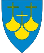
Coat of arms
The coat of arms was approved on 17 October 2019. The official blazon is "Azure, a plow and fish argent". This means the arms have a blue field (background) and the charge is an artistic design reminiscent of an interlocking fish and plow. The charge has a tincture of argent which means it is commonly colored white, but if it is made out of metal, then silver is used. The design was chosen to symbolize the two main industries of the municipality: fishing and agriculture. The arms were designed by Madelen Behrendt and Øystein Hauge. The municipal flag has the same design as the coat of arms.[8]
Churches
The Church of Norway has five parishes (sokn) within the municipality of Hustadvika. It is part of the Molde domprosti (arch-deanery) in the Diocese of Møre.
| Parish (sokn) | Church name | Location of the church | Year built |
|---|---|---|---|
| Bud | Bud Church | Bud | 1717 |
| Eide | Eide Church | Eide | 1871 |
| Gaustad Chapel | Gaustad, near Vevang | 2001 | |
| Hustad | Hustad Church | Hustad | 1874 |
| Myrbostad | Myrbostad Church | Elnesvågen | 1880 |
| Vågøy | Vågøy Church | Vågøya | 1904 |
Geography
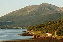
The municipality of Hustadvika sits on the northwestern end of the Romsdal Peninsula along the Hustadvika shoreline, just west of the island of Averøya. The Norwegian Sea lies to the north, the Harøyfjorden, Julsundet strait, and Aukra Municipality lie to the west, Molde Municipality and Gjemnes Municipality lie to the south, and Averøy Municipality and the Kornstadfjorden lie to the east.
The Frænfjorden cuts into the middle of the municipality. The coastal areas are low and marshy while the interior of the municipality is mountainous. Two of the more notable mountains are Jendemsfjellet and Heiane. The Bjørnsund islands lie off the northwestern coast. They are now uninhabited, but the Bjørnsund Lighthouse is still in operation. Kvitholmen Lighthouse lies just off the northern coast of the municipality, in an area with hundreds of small islands and skerries.
Government
All municipalities in Norway are responsible for primary education (through 10th grade), outpatient health services, senior citizen services, welfare and other social services, zoning, economic development, and municipal roads and utilities. The municipality is governed by a municipal council of directly elected representatives. The mayor is indirectly elected by a vote of the municipal council.[9] The municipality falls under the Møre og Romsdal District Court and the Frostating Court of Appeal.
Municipal council
The municipal council (Kommunestyre) of Hustadvika is made up of 37 representatives that are elected to four year terms. The party breakdown of the council is as follows:
| Party Name (in Norwegian) | Number of representatives | |
|---|---|---|
| Labour Party (Arbeiderpartiet) | 7 | |
| Progress Party (Fremskrittspartiet) | 4 | |
| Green Party (Miljøpartiet De Grønne) | 1 | |
| Conservative Party (Høyre) | 5 | |
| Christian Democratic Party (Kristelig Folkeparti) | 2 | |
| Centre Party (Senterpartiet) | 16 | |
| Socialist Left Party (Sosialistisk Venstreparti) | 1 | |
| Liberal Party (Venstre) | 1 | |
| Total number of members: | 37 | |
Notable people
- Oluf Gjerset (1848 in Vaagø – 1941) an American politician, Mayor of Montevideo, Minnesota
- Nilmar Janbu (1921 in Bjørnsund – 2013) a Norwegian engineer and geotechnician
- Arve Hans Otterlei (born 1932) a politician, Mayor of Fræna in 2003, lived in Hustad
- Trond Strande (born 1970) former footballer with 275 club caps with Molde FK, brought up in Elnesvågen
- Jim Svenøy (born 1972 in Fræna) a retired Norwegian athlete, ran the 3000 metre steeplechase
- Jorun Marie Kvernberg (born 1979 in Fræna) musician, singer and composer, plays the hardingfele and violin
- Ola Kvernberg (born 1981 in Fræna) a jazz musician, plays string swing violin
References
- "Navn på steder og personer: Innbyggjarnamn" (in Norwegian). Språkrådet.
- "Forskrift om målvedtak i kommunar og fylkeskommunar" (in Norwegian). Lovdata.no.
- Statistisk sentralbyrå. "Table: 06913: Population 1 January and population changes during the calendar year (M)" (in Norwegian).
- Statistisk sentralbyrå. "09280: Area of land and fresh water (km²) (M)" (in Norwegian).
- "Hustadvika kommune endelig vedtatt!" (in Norwegian). Fræna kommune. Archived from the original on 10 October 2017. Retrieved 9 October 2017.
- "Nye Eide og Fræna kommune" (in Norwegian). Archived from the original on 10 October 2017. Retrieved 9 October 2017.
- Rygh, Oluf (1908). Norske gaardnavne: Romsdals amt (in Norwegian) (13 ed.). Kristiania, Norge: W. C. Fabritius & sønners bogtrikkeri. pp. 99 and 314.
- "En stor takk til designerne av det nye kommunevåpenet og til arkitektene bak sangen "I kjem frå Hustadvika"" (in Norwegian). Hustadvika kommune. Retrieved 31 May 2019.
- Hansen, Tore; Vabo, Signy Irene, eds. (20 September 2022). "kommunestyre". Store norske leksikon (in Norwegian). Kunnskapsforlaget. Retrieved 14 October 2022.
- "Tall for Norge: Kommunestyrevalg 2019 - Møre og Romsdal" (in Norwegian). Statistics Norway. Retrieved 19 October 2019.
External links
- Municipal fact sheet from Statistics Norway (in Norwegian)
- Gjenvinningsbedrift gjekk konkurs – ingen tar ansvar for 1000 tonn avfall [Recirculation-company bankrupted - no one takes responsibility for 1000 tons of waste]. 23 November 2020. NRK
Møre og Romsdal county, Norway | |||
|---|---|---|---|
| |||
 | Towns and cities |
|  |
| Municipalities | |||