Conflict Group
The Conflict Group is an atoll in Papua New Guinea. The group was sighted in 1879 by HMS Cormorant, by moonlight; it was named in 1880 by Bower, captain of HMS Conflict.[3] Irai Island is the center of population of the group.
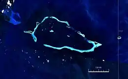 Satellite image | |
 | |
 Conflict Islands Location of the Conflict Islands | |
| Geography | |
|---|---|
| Location | Oceania |
| Coordinates | 10°46′48″S 151°47′32″E[1] |
| Archipelago | Louisiade Archipelago |
| Adjacent to | Solomon Sea |
| Total islands | 21 |
| Major islands | |
| Area | 4.55 km2 (1.76 sq mi) |
| Length | 21 km (13 mi) |
| Width | 10 km (6 mi) |
| Administration | |
| Province | |
| District | Samarai-Murua District |
| LLG[2] | Bwanabwana Rural LLG |
| Island Group | Calvados Chain |
| Largest settlement | Irai (pop. 20) |
| Demographics | |
| Population | 30 (2014) |
| Pop. density | 6.6/km2 (17.1/sq mi) |
| Ethnic groups | Papauans, Austronesians, Melanesians. |
| Additional information | |
| Time zone | |
| ISO code | PG-MBA |
| Official website | www |
The small Panasesa Island has an eco resort with a small staff.
In September 2022 the Papua New Guinea government ordered an investigation into the islands' ownership after their owner, Australian businessman Ian Gowrie Smith, attempted to sell them.[4]
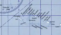
Islands in Conflict Group
The individual islands in a clockwise direction, starting in the west (Kisa and Itamarina in the lagoon):
| Name | Coordinates | Area km² |
|---|---|---|
| Ilai (Irai Island) | 10.7675°S 151.6925°E | 1.18 |
| Panasesa Island | 10.7400°S 151.7250°E | 0.68 |
| Madiboiboi? | 10.7306°S 151.7406°E | 0.10 |
| Gabugabutau | 10.7210°S 151.7485°E | 0.17 |
| Tubinagurm Island | 10.7175°S 151.7723°E | 0.25 |
| Lutmatavi Island | 10.7220°S 151.7874°E | 0.06 |
| Panaboal | 10.7393°S 151.8255°E | 0.52 |
| Ginara Island | 10.7521°S 151.8308°E | 0.14 |
| Panarakuum Island | 10.7699°S 151.8654°E | 0.51 |
| Panarakiim Motina | 10.7807°S 151.8808°E | 0.08 |
| Muniara Island | 10.8002°S 151.9032°E | 0.23 |
| Auriroa Island | 10.8064°S 151.9224°E | 0.76 |
| Panamaiia | 10.8341°S 151.8745°E | 0.06 |
| Tarapaniian | 10.8258°S 151.8403°E | 0.06 |
| Panaiiaii | 10.8207°S 151.8288°E | 0.05 |
| Kisa | 10.7821°S 151.8285°E | 0.08 |
| Itamarina | 10.7634°S 151.7711°E | 0.05 |
Differing surface areas, and sometimes divergent names for individual islands can be found in Oceandots: Irai (97 ha), Panasesa (63.5 ha), Auriora (61 ha), Panarakum (38.8 ha), Panibari (24.7 ha), Tubiniguam (17.8 ha), Moniara (13 ha), Ginouri (11 ha) and Tupit (10 ha). Thereafter, the total land area of the archipelago is 3.75 km².[5]
References
- Prostar Sailing Directions 2004 New Guinea Enroute, p. 168
- Selve B, Bwaduai S, Nisa M, James K, Usurup JP, Turner P, Melrose W, Yas W, Samuel R, Eddie C (2000). "Community empowerment in the control of lymphatic filariasis in Misima, Milne Bay Province using diethylcarbamazine in combination with albendazole" (PDF). The Papua New Guinea Medical Journal. 43 (3-4 Sep-Dec): 184. Archived from the original (PDF) on 11 August 2010.
- Arthur Wichman (Hrsg.): History of New-Guinea (bis 1828). Bd. 1, E. J. Brill, Leiden 1909, S. 271
- "Investigation into Conflict Islands". Papua New Guinea Post-Courier. 1 September 2022. Retrieved 1 September 2022.
- Oceandots.com: Conflict Islands