Cootawundy, New South Wales
Cootawundy in Central Darling Shire is a remote rural locality and civil parish of Yungnulgra County in far North West New South Wales.[1][2]
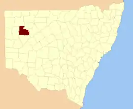
Yungnulgra County, NSW.
The Parish has an arid landscape, with extremely hot summers and mild winters. Summers would usually exceed 36 °C, and winters around 17 °C. The annual average rainfall is 249.7 millimetres (9.8 in) which would make it a semi-arid climate except that its high evapotranspiration, or its aridity, makes it a desert climate. The parish has a Köppen climate classification of BWh (Hot desert).[3] is almost unpopulated, with less than two inhabitants per square kilometer.[4]
The nearest town to Cootawundy is Whitecliffs.
References
- "Yungnulgra". Geographical Names Register (GNR) of NSW. Geographical Names Board of New South Wales. Retrieved 30 July 2013.
- Historic map of Yungnulgra County.
- Peel, M. C.; Finlayson, B. L.; McMahon, T. A. (2007). "Updated world map of the Köppen–Geiger climate classification". Hydrol. Earth Syst. Sci. 11: 1633–1644. doi:10.5194/hess-11-1633-2007. ISSN 1027-5606. (direct: Final Revised Paper)
- NASA Earth Observations: Population Density”. NASA/SEDAC..
This article is issued from Wikipedia. The text is licensed under Creative Commons - Attribution - Sharealike. Additional terms may apply for the media files.