List of counties in Iowa

There are 99 counties in the U.S. state of Iowa. The first two counties, Des Moines County and Dubuque County, were created in 1834 when Iowa was still part of the Michigan Territory. In preparation for Michigan's statehood, part of Michigan Territory was formed into Wisconsin Territory in 1836.[1] Two years later, the western portion was split off to become Iowa Territory.[2] The south-eastern part of Iowa Territory became Iowa, the 29th state in the union, on 28 December 1846,[3] by which point 44 counties had been created. Counties continued to be created by the state government until 1857, when the last county, Humboldt County, was created.[4] One of the most significant days in Iowa county history was January 15, 1851, on which 49 counties were created.[5]

Map of counties numbered as in the National Atlas of the United States

Counties of Iowa
LocationState of Iowa
Number99
Populations3,611 (Adams) – 501,089 (Polk)
Areas381 square miles (990 km2) (Dickinson) – 973 square miles (2,520 km2) (Kossuth)
Government
Subdivisions

The Iowa Constitution of 1857, which is still in effect today, states that counties must have an area of at least 432 square miles (1,120 km2), and no county may be reduced below that size by boundary changes.[6] However, exceptions to this rule were granted, as ten counties have areas below this size. (The table below shows land area, but the Constitution deals with total area.[6]) The smallest county (Dickinson) has a land area of 381 sq mi (990 km2), while the largest (Kossuth) has an area 973 sq mi (2,520 km2). Polk County is the most densely populated county at 864/sq mi (333.5/km2), an increase in density from 2010 when it was 655.5/sq mi (253.08/km2).[7] Polk County contains the state's capital and largest city, Des Moines. In addition, Iowa has one of the smallest percentages of counties whose boundaries are dictated by natural means, the vast majority of which are being formed by lines of survey instead, resulting in many "box counties".

County information

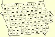
The Federal Information Processing Standard (FIPS) code, used by the United States government to uniquely identify counties, is provided with each entry. The FIPS code for each county links to census data for that county. The column labeled '#' is the official county number when listed alphabetically. This number is used for many governmental and organizational purposes, including state income tax preparation.[8] From 1930 to 1978, it was also used on Iowa license plates[9] until it was replaced by the full county name. Finally, the number in the column headed "Map #" is used by the National Atlas of the United States, shown on the left; for purposes of the National Atlas, counties are numbered in geographical order beginning in the NW corner of the map.

County
FIPS code[10] County seat[4] #
Est.[4][11] Formed from[12] Etymology[11]Map #
Population[13] Area[4] Map
Adair County 001 Greenfield01Jan 15, 1851Cass CountyJohn Adair, Kentucky Governor69 7,494 569 sq mi
(1,474 km2)
State map highlighting Adair County
Adams County 003 Corning02Jan 15, 1851Taylor CountyJohn Adams, US President81 3,611 424 sq mi
(1,098 km2)
State map highlighting Adams County
Allamakee County 005 Waukon03Feb 20, 1847Clayton CountyDisputed, possibly Allan Makee, early trader and guide for settlers, or Meskwaki anamiki and/or Ojibwe animikii both meaning thunder or thunderer[14]:3311 13,960 640 sq mi
(1,658 km2)
State map highlighting Allamakee County
Appanoose County 007 Centerville04Feb 17, 1843Davis CountyChief Appanoose, headed peace party in the Black Hawk War96 12,094 496 sq mi
(1,285 km2)
State map highlighting Appanoose County
Audubon County 009 Audubon05Jan 15, 1851Black Hawk County and Cass CountyJohn James Audubon, ornithologist and artist57 5,598 443 sq mi
(1,147 km2)
State map highlighting Audubon County
Benton County 011 Vinton06Dec 21, 1837Native American lands and Wisconsin TerritoryThomas Hart Benton, Missouri Senator51 25,711 716 sq mi
(1,854 km2)
State map highlighting Benton County
Black Hawk County 013 Waterloo07Feb 17, 1843Delaware CountyBlack Hawk, leader during Black Hawk War39 130,274 567 sq mi
(1,469 km2)
State map highlighting Black Hawk County
Boone County 015 Boone08Jan 13, 1846Polk CountyNathan Boone, one of the first to survey Iowa47 26,609 572 sq mi
(1,481 km2)
State map highlighting Boone County
Bremer County 017 Waverly09Jan 15, 1851Native American lands and Winnebago CountyFredrika Bremer, Swedish poet and author30 25,259 428 sq mi
(1,109 km2)
State map highlighting Bremer County
Buchanan County 019 Independence10Dec 21, 1837Delaware County and Wisconsin TerritoryJames Buchanan, US President40 20,714 571 sq mi
(1,479 km2)
State map highlighting Buchanan County
Buena Vista County 021 Storm Lake11Jan 15, 1851Clay County and Sac CountyBattle of Buena Vista, Mexican–American War24 20,600 575 sq mi
(1,489 km2)
State map highlighting Buena Vista County
Butler County 023 Allison12Jan 15, 1851Black Hawk County and Buchanan CountyWilliam Orlando Butler, War of 1812 hero29 14,269 580 sq mi
(1,502 km2)
State map highlighting Butler County
Calhoun County 025 Rockwell City13Jan 15, 1851Fox County (renamed)John C. Calhoun, US Vice President34 9,725 570 sq mi
(1,476 km2)
State map highlighting Calhoun County
Carroll County 027 Carroll14Jan 15, 1851Guthrie CountyCharles Carroll, signatory of the Declaration of Independence45 20,567 569 sq mi
(1,474 km2)
State map highlighting Carroll County
Cass County 029 Atlantic15Jan 15, 1851Pottawattamie CountyLewis Cass, Michigan Senator68 13,104 564 sq mi
(1,461 km2)
State map highlighting Cass County
Cedar County 031 Tipton16Dec 21, 1837Wisconsin TerritoryCedar River that runs through county65 18,399 580 sq mi
(1,502 km2)
State map highlighting Cedar County
Cerro Gordo County 033 Mason City17Jan 15, 1851Floyd CountyBattle of Cerro Gordo, Mexican–American War17 42,409 568 sq mi
(1,471 km2)
State map highlighting Cerro Gordo County
Cherokee County 035 Cherokee18Jan 15, 1851Crawford CountyCherokee People23 11,491 577 sq mi
(1,494 km2)
State map highlighting Cherokee County
Chickasaw County 037 New Hampton19Jan 15, 1851Fayette CountyChickasaw People19 11,716 505 sq mi
(1,308 km2)
State map highlighting Chickasaw County
Clarke County 039 Osceola20Jan 13, 1846Lucas CountyJames Clarke, Governor of Iowa Territory83 9,692 431 sq mi
(1,116 km2)
State map highlighting Clarke County
Clay County 041 Spencer21Jan 15, 1851Native American landsHenry Clay, Jr., officer in the Mexican–American War14 16,475 569 sq mi
(1,474 km2)
State map highlighting Clay County
Clayton County 043 Elkader22Dec 21, 1837Dubuque County and Wisconsin TerritoryJohn M. Clayton, Delaware Senator21 17,027 779 sq mi
(2,018 km2)
State map highlighting Clayton County
Clinton County 045 Clinton23Dec 21, 1837Dubuque County and Wisconsin TerritoryDeWitt Clinton, New York Governor66 46,344 695 sq mi
(1,800 km2)
State map highlighting Clinton County
Crawford County 047 Denison24Jan 15, 1851Shelby CountyWilliam Harris Crawford, Georgia Senator44 16,123 714 sq mi
(1,849 km2)
State map highlighting Crawford County
Dallas County 049 Adel25Jan 13, 1846Polk CountyGeorge Mifflin Dallas, US Vice President59 108,016 586 sq mi
(1,518 km2)
State map highlighting Dallas County
Davis County 051 Bloomfield26Feb 17, 1843Van Buren CountyGarrett Davis, Kentucky Congressman97 9,130 503 sq mi
(1,303 km2)
State map highlighting Davis County
Decatur County 053 Leon27Jan 13, 1846Appanoose CountyStephen Decatur, War of 1812 naval officer94 7,683 532 sq mi
(1,378 km2)
State map highlighting Decatur County
Delaware County 055 Manchester28Dec 21, 1837Dubuque County and Wisconsin TerritoryState of Delaware, home of Iowa statehood advocate US Senator John M. Clayton41 17,568 578 sq mi
(1,497 km2)
State map highlighting Delaware County
Des Moines County 057 Burlington29Sep 6, 1834Michigan Territory and Wisconsin TerritoryDes Moines River that once ran through the county89 38,293 416 sq mi
(1,077 km2)
State map highlighting Des Moines County
Dickinson County 059 Spirit Lake30Jan 15, 1851Kossuth CountyDaniel Stevens Dickinson, New York Senator3 18,028 381 sq mi
(987 km2)
State map highlighting Dickinson County
Dubuque County 061 Dubuque31Sep 6, 1834Michigan Territory and Wisconsin TerritoryJulien Dubuque, first permanent white settler in Iowa42 98,677 608 sq mi
(1,575 km2)
State map highlighting Dubuque County
Emmet County 063 Estherville32Jan 15, 1851Dickinson County and Kossuth CountyRobert Emmet, Irish revolutionary and American republican sympathizer4 9,176 396 sq mi
(1,026 km2)
State map highlighting Emmet County
Fayette County 065 West Union33Dec 21, 1837Clayton County and Wisconsin TerritoryMarquis de Lafayette, Frenchman who aided colonial forces during American Revolutionary War20 19,294 731 sq mi
(1,893 km2)
State map highlighting Fayette County
Floyd County 067 Charles City34Jan 15, 1851Chickasaw CountyCharles Floyd, member of Lewis and Clark Expedition who died in Iowa18 15,337 501 sq mi
(1,298 km2)
State map highlighting Floyd County
Franklin County 069 Hampton35Jan 15, 1851Chickasaw CountyBenjamin Franklin, statesman and US founding father28 9,916 582 sq mi
(1,507 km2)
State map highlighting Franklin County
Fremont County 071 Sidney36Feb 24, 1847Pottawattamie CountyJohn Charles Fremont, Mexican–American War officer90 6,464 511 sq mi
(1,323 km2)
State map highlighting Fremont County
Greene County 073 Jefferson37Jan 15, 1851Dallas CountyNathanael Greene, American Revolutionary War general46 8,741 568 sq mi
(1,471 km2)
State map highlighting Greene County
Grundy County 075 Grundy Center38Jan 15, 1851Black Hawk CountyFelix Grundy, Tennessee Congressman38 12,356 503 sq mi
(1,303 km2)
State map highlighting Grundy County
Guthrie County 077 Guthrie Center39Jul 8, 1851Jackson CountyEdwin B. Guthrie, Mexican–American War officer58 10,647 591 sq mi
(1,531 km2)
State map highlighting Guthrie County
Hamilton County 079 Webster City40Dec 22, 1856Webster CountyWilliam W. Hamilton, President of Iowa Senate (1856–1857)36 14,820 577 sq mi
(1,494 km2)
State map highlighting Hamilton County
Hancock County 081 Garner41Jan 15, 1851Wright CountyJohn Hancock, President of First Continental Congress16 10,685 571 sq mi
(1,479 km2)
State map highlighting Hancock County
Hardin County 083 Eldora42Jan 15, 1851Black Hawk CountyJohn J. Hardin, prominent soldier, Black Hawk War37 16,567 569 sq mi
(1,474 km2)
State map highlighting Hardin County
Harrison County 085 Logan43Jan 15, 1851Pottawattamie CountyWilliam Henry Harrison, US President55 14,658 697 sq mi
(1,805 km2)
State map highlighting Harrison County
Henry County 087 Mount Pleasant44Dec 7, 1836Wisconsin TerritoryDisputed, see reference[15]88 20,196 434 sq mi
(1,124 km2)
State map highlighting Henry County
Howard County 089 Cresco45Jan 15, 1851Chickasaw CountyTilghman Howard, US Representative from Indiana9 9,533 473 sq mi
(1,225 km2)
State map highlighting Howard County
Humboldt County 091 Dakota City46Feb 26, 1857Webster CountyAlexander von Humboldt, German scientist26 9,572 434 sq mi
(1,124 km2)
State map highlighting Humboldt County
Ida County 093 Ida Grove47Jan 15, 1851Cherokee CountyEither Mount Ida in Greece or Ida Smith, child of early settlers[16]32 6,888 432 sq mi
(1,119 km2)
State map highlighting Ida County
Iowa County 095 Marengo48Feb 17, 1843Washington CountyIowa River that flows through the county63 16,475 586 sq mi
(1,518 km2)
State map highlighting Iowa County
Jackson County 097 Maquoketa49Dec 21, 1837Wisconsin TerritoryAndrew Jackson, US President54 19,324 636 sq mi
(1,647 km2)
State map highlighting Jackson County
Jasper County 099 Newton50Jan 13, 1846Mahaska CountyWilliam Jasper, American Revolutionary War sergeant61 37,938 730 sq mi
(1,891 km2)
State map highlighting Jasper County
Jefferson County 101 Fairfield51Jan 21, 1839Native American landsThomas Jefferson, US President87 15,698 435 sq mi
(1,127 km2)
State map highlighting Jefferson County
Johnson County 103 Iowa City52Dec 21, 1837Des Moines County, Iowa and Wisconsin TerritoryRichard Mentor Johnson, US Vice President; officially renamed after Lulu Johnson (1907-1995)[17]64 156,420 614 sq mi
(1,590 km2)
State map highlighting Johnson County
Jones County 105 Anamosa53Dec 21, 1837Wisconsin TerritoryGeorge Wallace Jones, Iowa Senator53 20,848 575 sq mi
(1,489 km2)
State map highlighting Jones County
Keokuk County 107 Sigourney54Dec 21, 1837Washington CountyChief Keokuk74 9,904 579 sq mi
(1,500 km2)
State map highlighting Keokuk County
Kossuth County 109 Algona55Jan 15, 1851Webster CountyLajos Kossuth, Hungarian revolutionary inspired by American democratic ideals5 14,475 973 sq mi
(2,520 km2)
State map highlighting Kossuth County
Lee County 111 Fort Madison and Keokuk56Dec 7, 1836Des Moines CountyWilliam Elliott Lee, businessman from the New York Land Company, who sold the county's first tracts of land99 32,840 517 sq mi
(1,339 km2)
State map highlighting Lee County
Linn County 113 Cedar Rapids57Dec 21, 1837Wisconsin TerritoryLewis Fields Linn, doctor and Missouri Senator52 229,033 718 sq mi
(1,860 km2)
State map highlighting Linn County
Louisa County 115 Wapello58Dec 7, 1836Des Moines CountyDisputed, see reference[18]76 10,677 402 sq mi
(1,041 km2)
State map highlighting Louisa County
Lucas County 117 Chariton59Jan 13, 1846Monroe CountyRobert Lucas, first Governor of Iowa Territory84 8,689 431 sq mi
(1,116 km2)
State map highlighting Lucas County
Lyon County 119 Rock Rapids60Jan 15, 1851Woodbury County, IowaNathaniel Lyon, first Union general to be killed in the American Civil War, (formerly named Buncombe County)1 12,179 588 sq mi
(1,523 km2)
State map highlighting Lyon County
Madison County 121 Winterset61Jan 13, 1846Polk CountyJames Madison, US President70 17,036 561 sq mi
(1,453 km2)
State map highlighting Madison County
Mahaska County 123 Oskaloosa62Feb 17, 1843Fox and Sac Indian landsChief Mahaska73 21,946 571 sq mi
(1,479 km2)
State map highlighting Mahaska County
Marion County 125 Knoxville63Jun 10, 1845Washington CountyFrancis Marion, American Revolutionary War general72 33,642 554 sq mi
(1,435 km2)
State map highlighting Marion County
Marshall County 127 Marshalltown64Jan 13, 1846Jasper CountyJohn Marshall, Chief Justice of the United States Supreme Court49 39,879 572 sq mi
(1,481 km2)
State map highlighting Marshall County
Mills County 129 Glenwood65Jan 15, 1851Pottawattamie CountyFrederick Mills, major killed during the Battle of Churubusco, Mexican–American War79 14,553 437 sq mi
(1,132 km2)
State map highlighting Mills County
Mitchell County 131 Osage66Jan 15, 1851Chickasaw CountyJohn Mitchel, Irish revolutionary who operated out of the US8 10,532 469 sq mi
(1,215 km2)
State map highlighting Mitchell County
Monona County 133 Onawa67Jan 15, 1851Harrison CountyProbably from the name of a fictional Native American character in a play[14]:29543 8,486 693 sq mi
(1,795 km2)
State map highlighting Monona County
Monroe County 135 Albia68Feb 17, 1843Wapello CountyJames Monroe, US President85 7,550 433 sq mi
(1,121 km2)
State map highlighting Monroe County
Montgomery County 137 Red Oak69Jan 15, 1851Polk CountyRichard Montgomery, American Revolutionary War general80 10,205 424 sq mi
(1,098 km2)
State map highlighting Montgomery County
Muscatine County 139 Muscatine70Dec 7, 1836Des Moines Countydebated, possibly Mascouten People77 42,377 439 sq mi
(1,137 km2)
State map highlighting Muscatine County
O'Brien County 141 Primghar71Jan 15, 1851Cherokee CountyWilliam Smith O'Brien, Irish revolutionary inspired by American democratic ideals13 14,060 573 sq mi
(1,484 km2)
State map highlighting O'Brien County
Osceola County 143 Sibley72Jan 15, 1851Woodbury CountyOsceola, Seminole leader2 6,036 399 sq mi
(1,033 km2)
State map highlighting Osceola County
Page County 145 Clarinda73Feb 24, 1847Pottawattamie CountyJohn Page, officer killed in Battle of Palo Alto, Mexican–American War91 15,143 535 sq mi
(1,386 km2)
State map highlighting Page County
Palo Alto County 147 Emmetsburg74Jan 15, 1851Kossuth CountyBattle of Palo Alto, Mexican–American War15 8,764 564 sq mi
(1,461 km2)
State map highlighting Palo Alto County
Plymouth County 149 Le Mars75Jan 15, 1851Woodbury CountyPlymouth, Massachusetts22 25,681 864 sq mi
(2,238 km2)
State map highlighting Plymouth County
Pocahontas County 151 Pocahontas76Jan 15, 1851Greene County and Humboldt CountyPocahontas, famous Native American woman25 7,053 578 sq mi
(1,497 km2)
State map highlighting Pocahontas County
Polk County 153 Des Moines77Jan 13, 1846Native American landsJames K. Polk, US President60 501,089 570 sq mi
(1,476 km2)
State map highlighting Polk County
Pottawattamie County 155 Council Bluffs78Feb 24, 1847Native American landsPotawatomi People67 93,173 954 sq mi
(2,471 km2)
State map highlighting Pottawattamie County
Poweshiek County 157 Montezuma79Feb 17, 1843Meskwaki landsChief Poweshiek, Meskwaki62 18,467 585 sq mi
(1,515 km2)
State map highlighting Poweshiek County
Ringgold County 159 Mount Ayr80Feb 24, 1847Taylor CountySamuel Ringgold, major killed in the Mexican–American War93 4,670 538 sq mi
(1,393 km2)
State map highlighting Ringgold County
Sac County 161 Sac City81Jan 15, 1851Greene CountySauk (Sac) People33 9,673 576 sq mi
(1,492 km2)
State map highlighting Sac County
Scott County 163 Davenport82Dec 21, 1837Wisconsin TerritoryWinfield Scott, War of 1812 General78 173,924 458 sq mi
(1,186 km2)
State map highlighting Scott County
Shelby County 165 Harlan83Jan 15, 1851Cass CountyIsaac Shelby, American Revolutionary War General, War of 181256 11,645 591 sq mi
(1,531 km2)
State map highlighting Shelby County
Sioux County 167 Orange City84Jan 15, 1851Plymouth CountySioux People12 36,050 768 sq mi
(1,989 km2)
State map highlighting Sioux County
Story County 169 Nevada85Jan 13, 1846Boone County, Jasper County, and Polk CountyJoseph Story, US Supreme Court Justice48 99,673 573 sq mi
(1,484 km2)
State map highlighting Story County
Tama County 171 Toledo86Feb 17, 1843Benton County and Boone CountyDisputed, see reference[19]50 16,903 721 sq mi
(1,867 km2)
State map highlighting Tama County
Taylor County 173 Bedford87Feb 24, 1847Page CountyZachary Taylor, US President92 5,858 534 sq mi
(1,383 km2)
State map highlighting Taylor County
Union County 175 Creston88Jan 15, 1851Clarke CountyThe union of the states82 11,887 424 sq mi
(1,098 km2)
State map highlighting Union County
Van Buren County 177 Keosauqua89Dec 7, 1836Des Moines CountyMartin Van Buren, US President98 7,256 485 sq mi
(1,256 km2)
State map highlighting Van Buren County
Wapello County 179 Ottumwa90Feb 17, 1843Native American landsChief Wapello86 35,043 432 sq mi
(1,119 km2)
State map highlighting Wapello County
Warren County 181 Indianola91Jan 13, 1846Polk CountyJoseph Warren, American Revolutionary War General71 54,327 572 sq mi
(1,481 km2)
State map highlighting Warren County
Washington County 183 Washington92Jan 25, 1839Wisconsin TerritoryGeorge Washington, US President75 22,571 569 sq mi
(1,474 km2)
State map highlighting Washington County
Wayne County 185 Corydon93Jan 13, 1846Appanoose CountyAnthony Wayne, American Revolutionary War General95 6,467 526 sq mi
(1,362 km2)
State map highlighting Wayne County
Webster County 187 Fort Dodge94Jan 12, 1853Risley County and Yell County (defunct IA counties)[20]Daniel Webster, Massachusetts Senator35 36,626 715 sq mi
(1,852 km2)
State map highlighting Webster County
Winnebago County 189 Forest City95Jan 15, 1851Kossuth CountyWinnebago (Ho–Chunk) People6 10,617 400 sq mi
(1,036 km2)
State map highlighting Winnebago County
Winneshiek County 191 Decorah96Feb 20, 1847Native American landsChief Winneshiek10 19,974 690 sq mi
(1,787 km2)
State map highlighting Winneshiek County
Woodbury County 193 Sioux City97Jan 12, 1853Wahkaw County (renamed), Polk CountyLevi Woodbury, New Hampshire Governor31 105,671 873 sq mi
(2,261 km2)
State map highlighting Woodbury County
Worth County 195 Northwood98Jan 15, 1851Mitchell CountyWilliam Jenkins Worth, Black Hawk War and Mexican–American War officer7 7,319 400 sq mi
(1,036 km2)
State map highlighting Worth County
Wright County 197 Clarion99Jan 15, 1851Webster County and Kossuth CountySilas Wright, New York Governor, and Joseph Albert Wright, Indiana Governor (brothers)27 12,681 581 sq mi
(1,505 km2)
State map highlighting Wright County

Former counties

The following counties no longer exist:[21]

See also

References

  1. "The Creation of Wisconsin Territory". Wisconsin Historical Society. Retrieved 2008-08-17.
  2. "Chronology of Wisconsin History". Ney Family History. Archived from the original on 2008-05-19. Retrieved 2008-08-17.
  3. "Statehood Dates". 50states.com. Retrieved 2008-08-17.
  4. National Association of Counties. "NACo - Find a county". Archived from the original on 2005-04-10. Retrieved 2008-04-30.
  5. "Iowa: Consolidated Chronology of State and County Boundaries". Archived from the original on 2009-04-16. Retrieved 2008-05-25.
  6. "Iowa Commentary". Iowa Atlas of Historical County Boundaries. Archived from the original on 2008-10-15. Retrieved 2008-08-16.
  7. U.S. Census Bureau. "Polk County Quickfacts". State & County QuickFacts. Archived from the original on 2011-07-29. Retrieved 2021-09-03.
  8. "Iowa County Names and Numbers" (PDF). Iowa Department of Revenue. Archived from the original (PDF) on 2017-03-23. Retrieved 2018-06-08.
  9. "Iowa License Plate: County Codes". Archived from the original on 2018-12-19. Retrieved 2018-06-08.
  10. "EPA County FIPS Code Listing". EPA.gov. Retrieved 2008-02-23.
  11. Pratt, LeRoy G. (1977). The Counties and Courthouses of Iowa. Mason City, Iowa: Klipto Printing and Office Supply Company.
  12. "Formation of Counties in Iowa". Retrieved 2015-12-24.
  13. "U.S. Census Bureau QuickFacts: Iowa". United States Census Bureau. Retrieved 2023-04-07.
  14. Bright, William (2004). Native American Placenames of the United States. Norman, Oklahoma: University of Oklahoma Press. ISBN 978-0-8061-3598-4.
  15. "Henry County, Iowa". Retrieved 2008-08-17. According to most sources, Henry County (440 square miles) was named for Henry Dodge (1782-1867), who served in the Black Hawk War and other Indian wars and governor of Wisconsin Territory (1836-1841); others credit the county's name to General James Dougherty Henry (1797-1834), a hero of the Black Hawk War.
  16. Savage, Tom (2007). A Dictionary of Iowa Place-names. Iowa City: University of Iowa Press. p. 9. ISBN 1-58729-531-8.
  17. Doubek, James (June 27, 2021). "Johnson County, Iowa, Renames Itself After A Different Johnson". National Public Radio. Retrieved June 28, 2021.
  18. "Louisa County, Iowa". Official website. Retrieved 2008-08-17. According to some authorities, the county was named for Louisa Massey, who gained fame during her time because she avenged the murder of her brother by shooting the man responsible. Other historians claim the name was given in honor of Louisa County, Virginia. There are 418 square miles (1,080 km2) in Louisa County.
  19. John Adams, Tama County Auditor (2002). "Tama County, Iowa". e-referencedesk.com. Clarksville, VA: Web Marketing Services, Inc. LLC. Archived from the original on 2011-06-06. Retrieved 2008-10-02. The origin of the naming of Tama County is somewhat disputed. Some authorities say the name comes from Taimah, a Fox Indian Chief. Others say it comes from Taomah, wife of Poweshiek--another Fox Indian Tribe Chief. Still others say the county is named after the Indian Chief Potama or Pottama.
  20. Pratt, H. M. (1913). History of Fort Dodge and Webster County, Iowa.
  21. "Iowa County Formation Table". Iowa Genweb Project. Retrieved 2015-12-24.
  22. "Bancroft County, Iowa". Archived from the original on 2011-07-27. Retrieved 2008-08-16.
  23. "Cook County, Iowa". Archived from the original on 2004-07-14. Retrieved 2008-08-16.
  24. "Crocker County, Iowa". Archived from the original on 2004-07-15. Retrieved 2008-08-16.
  25. "Risley County, Iowa". Archived from the original on 2016-02-20. Retrieved 2008-08-16.
  26. "Yell County, Iowa". Archived from the original on 2004-07-20. Retrieved 2008-08-16.
This article is issued from Wikipedia. The text is licensed under Creative Commons - Attribution - Sharealike. Additional terms may apply for the media files.