County of Belmore

The County of Belmore is a county in Queensland, Australia,[1] located west of the Darling Downs in the Shire of Balonne.[2]

Belmore
Queensland
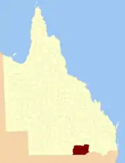
Location within Queensland
Lands administrative divisions around Belmore:
Tomoo Maranoa,
Elgin
Pring
Mungallala,
Nebine
Belmore Carnarvon
Narran (NSW) Finch (NSW) Benarba (NSW)

Like all counties in Queensland, it is a non-functional administrative unit, that is used mainly for the purpose of registering land titles.[3] It was officially named and bounded by the Governor in Council on 7 March 1901 under the Land Act 1897.[1]

county in 1890

Like all counties in Queensland, it is a non-functional administrative unit, that is used mainly for the purpose of registering land titles. From 30 November 2015, the government no longer referenced counties and parishes in land information systems however the Museum of Lands, Mapping and Surveying retains a record for historical purposes.[4]


Parishes

Belmore is divided into parishes, listed as follows:

ParishLGACoordinatesTowns
AltonBalonne28°06′S 149°15′EAlton
BallagnaBalonne28°13′S 149°01′E
BoahBalonne28°29′S 148°21′E
BogiriaBalonne28°55′S 147°47′EHebel
BollonBalonne28°01′S 147°26′EBollon
BoogahBalonne28°21′S 147°26′E
BookalongBalonne28°37′S 148°23′E
BooligarBalonne28°42′S 148°16′E
BoombahBalonne28°12′S 148°39′E
BoomiBalonne28°35′S 147°28′E
BorgeraBalonne27°55′S 147°47′E
BrendaBalonne28°51′S 147°26′E
BriarieBalonne28°49′S 147°43′E
BullamonBalonne28°40′S 148°53′EThallon
BullindgieBalonne28°16′S 147°56′E
BumbleBalonne28°49′S 148°27′E
BurgorahBalonne27°59′S 148°44′E
ByraBalonne28°55′S 147°15′E
CardiffBalonne27°54′S 147°33′E
CawildiBalonne28°28′S 148°13′E
ChippewayBalonne28°04′S 147°58′E
CodernahBalonne28°45′S 147°53′E
CollybenBalonne28°52′S 148°59′E
CowigellaBalonne28°38′S 147°46′E
CubbieBalonne28°39′S 148°01′E
CulgoaBalonne28°45′S 147°20′E
CunnianaBalonne28°35′S 148°40′E
CuoygahBalonne28°50′S 148°10′E
CurrawildiBalonne28°41′S 148°08′EDirranbandi
CurrawillinghiBalonne28°56′S 147°37′E
DareelBalonne28°49′S 148°50′EDareel
DewurraBalonne28°14′S 147°35′E
DoondiBalonne28°23′S 148°25′E
DunwinnieBalonne28°40′S 148°38′E
EugunBalonne28°07′S 148°19′E
EurabaBalonne28°48′S 148°00′E
FairymountGoondiwindi28°07′S 149°22′E
GeraldaGoondiwindi28°18′S 149°16′E
GerarBalonne28°32′S 148°52′E
GnooloomaBalonne28°56′S 148°38′E
GoonaroBalonne28°56′S 147°59′E
GoulamainBalonne27°53′S 149°03′E
GulnarbarBalonne28°07′S 148°29′E
GurarderaGoondiwindi28°26′S 149°15′E
Guy GuyBalonne28°14′S 148°23′E
HollymountBalonne28°05′S 149°07′E
KareeBalonne28°20′S 148°33′E
KatootaBalonne27°51′S 148°45′E
KeebrahBalonne28°32′S 148°07′E
KirkBalonne28°10′S 148°08′E
KooroonBalonne27°52′S 149°25′E
KulkiBalonne28°34′S 147°37′E
KullinjahBalonne27°57′S 148°14′E
MarillaBalonne28°57′S 148°13′E
MaroungleBalonne27°58′S 148°23′E
MelangaBalonne28°25′S 148°43′E
MinimiBalonne28°07′S 148°51′E
MonaBalonne28°09′S 147°24′E
MoombahBalonne27°53′S 149°14′E
MuganGoondiwindi28°45′S 149°05′E
MungindiBalonne28°56′S 148°52′EMungindi
NewingaGoondiwindi28°36′S 149°21′E
NindigullyBalonne28°22′S 148°53′ENindigully
NinghamBalonne28°16′S 148°50′E
NoondooBalonne28°48′S 148°38′E
RunnymedeBalonne28°22′S 147°15′E
St GeorgeBalonne28°05′S 148°40′ESt George
ShirleyBalonne28°29′S 148°31′E
ThombyBalonne27°57′S 148°53′E
TilquinBalonne28°05′S 147°32′E
TootherangBalonne28°30′S 147°53′E
TowtowriBalonne27°56′S 147°57′E
UhrBalonne28°06′S 147°43′E
WagailyBalonne27°59′S 148°34′E
WandibingieGoondiwindi28°34′S 149°08′E
WeengallonGoondiwindi28°22′S 149°02′EWeengallon
WeeyanBalonne27°44′S 148°50′E
WhitalbyBalonne28°11′S 147°50′E
WhyenbahBalonne28°19′S 148°14′E
WillarieGoondiwindi28°40′S 149°14′E
WombilBalonne28°23′S 148°03′E
WonditBalonne27°56′S 148°04′E
WoolerinaBalonne28°43′S 147°35′E
WungerBalonne27°44′S 149°03′E
WyenbirraBalonne28°34′S 147°17′E
YammaBalonne28°25′S 147°38′E
YangleBalonne28°54′S 148°24′E

References

  1. "Belmore (entry 2237)". Queensland Place Names. Queensland Government. Retrieved 1 September 2015.
  2. Queensland showing counties / compiled and published at the Survey Department, Brisbane, Brisbane : Survey Dept., 1900.
  3. Maranoa District, County of Belmore Maps - R1 Series at Queensland Archives.
  4. "Locality boundaries - Queensland". Department of Natural Resources, Mines and Energy. 27 August 2017. Archived from the original on 31 March 2018. Retrieved 2 October 2018.

28°02′S 148°35′E

This article is issued from Wikipedia. The text is licensed under Creative Commons - Attribution - Sharealike. Additional terms may apply for the media files.