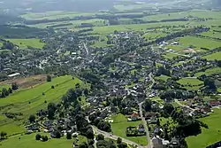
Dahlem, North Rhine-Westphalia
Dahlem is a municipality in the district of Euskirchen. It has the lowest population density and population of all municipalities of in the state of North Rhine-Westphalia, Germany. It is located in the Eifel hills, approx. 35 km south-west of Euskirchen. The small medieval town Kronenburg is part of the municipality.
Dahlem | |
|---|---|
 | |
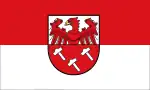 Flag  Coat of arms | |
Location of Dahlem within Euskirchen district 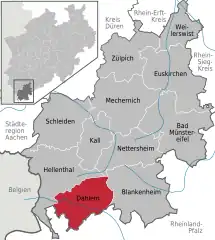 | |
 Dahlem  Dahlem | |
| Coordinates: 50°23′N 06°33′E | |
| Country | Germany |
| State | North Rhine-Westphalia |
| Admin. region | Köln |
| District | Euskirchen |
| Government | |
| • Mayor (2020–25) | Jan Lembach[1] (CDU) |
| Area | |
| • Total | 95.18 km2 (36.75 sq mi) |
| Elevation | 539 m (1,768 ft) |
| Population (2021-12-31)[2] | |
| • Total | 4,361 |
| • Density | 46/km2 (120/sq mi) |
| Time zone | UTC+01:00 (CET) |
| • Summer (DST) | UTC+02:00 (CEST) |
| Postal codes | 53949 |
| Dialling codes | 02447 |
| Vehicle registration | EU |
| Website | www.dahlem.de |
Geography
Dahlem is located in the northern Eifel region in the High Fens – Eifel Nature Park between Blankenheim in the Northeast and Stadtkyll the southwest. The Kyll flows through the region from the Glaadtbach. The Heidenköpfe lie in the Ripsdorfer forest to the east.
References
- Wahlergebnisse in NRW Kommunalwahlen 2020, Land Nordrhein-Westfalen, accessed 19 June 2021.
- "Bevölkerung der Gemeinden Nordrhein-Westfalens am 31. Dezember 2021" (in German). Landesbetrieb Information und Technik NRW. Retrieved 20 June 2022.
External links
![]() Media related to Dahlem (Nordeifel) at Wikimedia Commons
Media related to Dahlem (Nordeifel) at Wikimedia Commons
Towns and municipalities in Euskirchen (district) | ||
|---|---|---|
Coat of Arms of Euskirchen County | ||
This article is issued from Wikipedia. The text is licensed under Creative Commons - Attribution - Sharealike. Additional terms may apply for the media files.