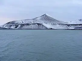
Cross Hill, Deception Island
Cross Hill is a hill of 525 feet on Deception Island in the South Shetland Islands.
| Cross hill | |
|---|---|
 Cross Hill viewed from Stancomb Cove in Telefon Bay. | |
| Highest point | |
| Elevation | 160 m (520 ft) |
| Coordinates | 62.935°S 60.6933°W |
The hill stand on the west side of the island, to the south-west of Telefon Bay.
After the island was surveyed by the Falkland Islands Dependencies Survey in January 1954, this peak was named 'Cross Hill' from the large wooden cross, probably erected by whalers, near the summit.[1][2]
A name attributed by a 1952 Argentine chart is Monte de la Laguna,[3] meaning 'mountain of the lake', in association with the nearby Crater Lake, and it has appeared as 'Laguna Hill' in some American resources.[4]
See also
References
- Composite Gazetteer of Antarctica: Cross Hill
- APC, 1958, p.4; DOS 310 Deception Island sheet, 1960
- "Laguna Hill". Geographic Names Information System. United States Geological Survey, United States Department of the Interior. Retrieved 24 May 2013.
- 'Laguna Hill': USBGN, 1965, p.100)
This article is issued from Wikipedia. The text is licensed under Creative Commons - Attribution - Sharealike. Additional terms may apply for the media files.