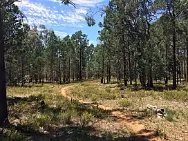
Cullivel State Forest
Cullivel State Forest is a native forest, located in the South Western Slopes region of New South Wales, in eastern Australia. The 155 ha (380-acre)[4] state forest is located approximately 16 km (9.9 mi) north-east of Urana.[5]
| Cullivel State Forest | |
|---|---|
 White cypress pine forest | |
| Geography | |
| Location | South Western Slopes, New South Wales, Australia |
| Coordinates | 35°14′19″S 146°24′44″E |
| Area | 155 ha (1.6 km2; 0.6 sq mi) |
| Administration | |
| Governing body | Forestry Corporation of NSW[1] |
| Ecology | |
| Dominant tree species | White cypress pine[2] |
| Lesser flora | Grey box[3] |
The now-closed section of the Oaklands railway line passes through the northern section of the state forest.[2]
Environment
Cullivel State Forest is dominated by white cypress pine.[2] Other plant species present within the forest include Grey box and Bulloak.[3]
At least three species listed under the Biodiversity Conservation Act 2016 have been recorded within the state forest,[2] including Grey-crowned babbler.[2]
See also
References
- "NSW State Forests" (PDF). Forestry Corporation. 17 March 2014. Archived (PDF) from the original on 5 March 2023. Retrieved 25 March 2023.
- "Regional Forest Assessment: South-western cypress state forests" (PDF). Natural Resources Commission. Archived (PDF) from the original on 14 March 2023. Retrieved 25 March 2023.
- "Urana - Native Vegetation Map ADS-40 Edition 2". Office of Environment & Heritage. February 2012. Archived from the original on 30 October 2022. Retrieved 25 March 2023.
- "Lockhart Shire Council – 2014-15 State of the Environment Report" (PDF). Lockhart Shire. Archived (PDF) from the original on 31 July 2021. Retrieved 25 March 2023.
- "Forests NSW forest management zones - Riverina Region" (PDF). Forestry Corporation of NSW. January 2008. Archived (PDF) from the original on 7 March 2023. Retrieved 25 March 2023.
This article is issued from Wikipedia. The text is licensed under Creative Commons - Attribution - Sharealike. Additional terms may apply for the media files.