Curepipe
Curepipe (Mauritian Creole pronunciation: [kiːəpip]) also known as La Ville-Lumière (The City of Light), is a town in Mauritius, located in the Plaines Wilhems District, the eastern part also lies in the Moka District. The town is administered by the Municipal Council of Curepipe. Curepipe lies at a higher elevation, often referred to as the "Central Plateau". According to the census made by Statistics Mauritius in 2018, the population of the town was at 78,618.[2]
Curepipe
La Ville-Lumière | |
|---|---|
Town | |
| Curepipe | |
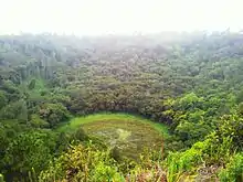
.jpg.webp) The view from Trou aux Cerfs, one of the highest points in Curepipe. | |
 Seal | |
| Motto(s): | |
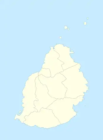 Curepipe Municipal Council location | |
| Coordinates: 20°19′7.59″S 57°31′34.66″E | |
| Country | |
| District | Plaines Wilhems |
| Government | |
| • Type | Municipality |
| • Mayor | Hans Berty Margueritte |
| • Deputy Mayor | Chellen Samy |
| Area | |
| • Total | 24 km2 (9 sq mi) |
| Elevation | 561 m (1,841 ft) |
| Population (2018)[2] | |
| • Total | 78,618 |
| • Rank | 4th in Mauritius |
| • Density | 3,300/km2 (8,500/sq mi) |
| Time zone | UTC+4 (MUT) |
| Climate | Cfa |
| Website | municipal-curepipe.org |
Etymology
The town's name, Curepipe, is said to be originated from the French curer sa pipe, which translates to "cleaning his/her pipe". There are several theories by historians as to the naming of the city. Some historians believe that the name was given as travellers and soldiers from the 19th century often travelled from Port Louis and Grand Port (now Mahébourg) to refill their pipes in Curepipe. Other historians believe that the name was given after a late landowner during the 18th century.[3]
Geography
The town officially covers an area of 23.8 square kilometres (9.2 sq mi). It is located in the Plaine Wilhems district on the central plateau of Mauritius at an altitude of 561 meters. Of the larger towns of the island's central plateau, Curepipe is the most southern and also the highest. As a consequence of its height, Curepipe is known for its relatively cooler and rainier climate.[4] The dormant volcano Trou aux Cerfs is nearby.
Politics
Curepipe is managed by a council, which is democratically elected by its citizens. The council is headed by the Mayor and is principally responsible for local policy making. The current Mayor is Mr. Hans Berty Margueritte. The town's administration on the other hand is responsible for the implementation of these policies as well as the day-to-day management of the council's activities. The current administrative head is Mrs Jugroop[5][6]
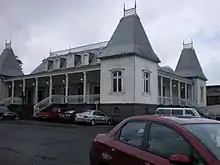
Curepipe's historic town hall was actually originally situated in Moka, and the whole building was moved to Curepipe in 1903.[7]
For the general elections the town is classified as the No 17 constituency known as Curepipe and Midlands.
Demographics
According to the census made by Statistics Mauritius in 2018, the population of the town was at 78,692.[2] The primary spoken language is Mauritian Creole, though French predominates in more formal situations. Tamil, Bhojpuri, Hindi, Telugu, Urdu, Mandarin and Hakka Chinese are also spoken as second or third language mostly in religious activities. The council's official language is English.
Religion
According to the 2012 census conducted by Statistics Mauritius, Christianity is the most prevalently practised religion in Curepipe (48.4%) (Catholic 39.2%, Protestant 1.3%, Other Christian 8%), followed by Hinduism (37.7%) and Islam (13.9%).
Economic activities
The town hosts several textile factories, a diamond processing industry and a range of jewelry businesses. In addition, handicraft shops, restaurants and shopping centres add to the commercial mix of the town. The relatively affluent suburbs are also home to a great deal of business activity.
Sustainable development
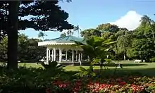
The town council is acutely aware of the need to bring principles of sustainability into the town's economic development. Prominent projects include the segregation of waste, judicious use of water, parking problems, the encouraging of public transport, the promotion of the SSR Curepipe Botanic Gardens and working towards minimizing the town's carbon footprint. In 2011 the town joined ICLEI - Local Governments for Sustainability.
Recently, the council embarked on a project nicknamed "For a Greener Curepipe" in collaboration with Gender Links Mauritius, in order to spur the growing environmental interest of Curepipe's citizens. Tree planting, backyard composting and food growing was encouraged, and a range of community organisations from schools to women's groups were involved.
Sensitization programmes are also underway in collaboration with the Central Water Authority of Mauritius, towards encouraging a more judicious management of the town's water resources.[8]
Tourism
Curepipe, though inland from the main coastal tourist areas of Mauritius, is nonetheless a tourist destination. Some of the more popular attractions include:
- Curepipe Botanic Gardens
- Trou aux Cerfs Crater
- Monvert Nature Park
- Sainte Therese Church
- Carnegie Library of Curepipe
- The old Town Hall
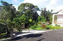
- Domaine des Aubineaux
- The Basilica of Sainte Helene
- La Sabloniere
- Casino de Maurice
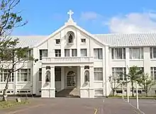
- St. Joseph's College (National Heritage)
- Royal College Curepipe (National Heritage)
Education
Curepipe is home to various secondary schools which include the Ambassador College, Floreal SSS, Curepipe College, Dar-ul-Maarif Secondary School, Doha Secondary School, Dunputh Lallah SSS, Forest Side SSS Boys, Forest Side SSS Girls, Full Day School, Hindu Girls College, Imperial College, Loreto College Curepipe, Lycee Labourdonnais,[9] Mauricia Institute, Mauritius College Boys, Mauritius College Girls, Notre Dame College, Ocep College, Presidency College Boys, Presidency College Girls, Renaissance College, St Patrick's College, Royal College Curepipe and St. Joseph's College.
Sports
The town is home to the Stade George V, the teams of the town are the Curepipe Starlight SC and the current champions Cercle de Joachim, they currently play in the National First Division for the 2015–2016 season.
Suburbs
The town of Curepipe is divided into different regions.[10][11]
- Allée Brillant
- Résidence Atlee
- Couvent Lorette
- Curepipe Road
- Eau-Coulée
- Engrais-Cathan
- Engrais-Martial
- Floréal
- Forest-Side
- Malherbes
- Wooton
- Camp Caval
- Cité Joachim
- Cité St-Luc
- Cité Loyseau
- Mangalkhan
- Robinson
- Les Casernes
- Route du Jardin
- La Brasserie
- Camp Pierrot
- Cité Anoska
References
- "Archived copy". Archived from the original on 4 April 2014. Retrieved 20 October 2013.
{{cite web}}: CS1 maint: archived copy as title (link) - Statistics Mauritius: Demography Unit (2018). "DIGEST OF DEMOGRAPHIC STATISTICS 2018" (PDF). Dec. Government of Mauritius: 33. Retrieved 21 May 2020.
{{cite journal}}: Cite journal requires|journal=(help) - "Les origines de la ville de Curepipe" (in French). Le Defimedia. Archived from the original on 4 April 2014. Retrieved 14 December 2012.
{{cite journal}}: Cite journal requires|journal=(help) - History of Curepipe
- "Administration Department". Municipal Council Of Curepipe.
- "Actual Mayor and Deputy". Municipal Council Of Curepipe.
- "Curepipe" Mauritius Things to Do Tip by bijo69
- Building Permits: Curepipe Promotes the Collection of Rainwater
- Home page. Lycée La Bourdonnais. Retrieved on May 4, 2015. "Rue Rochecouste - Forest Side - Curepipe - MAURICE"
- Ministry of Local Government and Outer Islands. "Local Government Act 2011" (PDF). Government of *Mauritius: 768–770. Archived from the original (PDF) on 14 November 2012. Retrieved 14 December 2012.
{{cite journal}}: Cite journal requires|journal=(help) - "Municipales et villageoises : les 6 principaux changements" (in French). Le Defimedia. Archived from the original on 23 November 2012. Retrieved 14 December 2012.
{{cite journal}}: Cite journal requires|journal=(help)