Cynopolis
Cynopolis (Greek: Κυνόπολις and Κυνῶν πόλις for "city of the dog"[1]) was the Hellenistic toponym for two cities in ancient Egypt. Both Cynopolis superior and Cynopolis inferior were bishoprics in Christian times.[2]
Cynopolis | |
|---|---|
Town | |
| Etymology: "City of the dog" | |
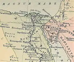
 A map of Ancient Egypt |
Cynopolis superior
| Sꜣkꜣ[3][4] in hieroglyphs | ||||||||||
|---|---|---|---|---|---|---|---|---|---|---|
Cynopolis was the Greek name for the ancient Egyptian town of Saka (or Hardai?); (Coptic: Ⲕⲁⲓⲥ or Ⲕⲟⲉⲓⲥ[5]) in the seventeenth nome of Upper Egypt,[6] was home to the cult of Anubis,[7] a canine-shaped deity. According to Claudius Ptolemy, the town was situated on an island in the river.[8] The modern settlement of El Kays now stands on the site.[9] The nome of Cynopolis extended to both banks of the Nile.[10]
A burial ground for dogs was discovered on the opposite bank of the Nile, near Hamatha.[11][12] The neighbouring cities were rivals according to Plutarch, who wrote (De Iside, 72) that when a Cynopolis resident ate an Oxyrhynchos fish, the people of Oxyrhynchos started attacking dogs in revenge, which resulted in a minor civil war.[13]
Cynopolis was destroyed by the viceroy of Nubia Pinehesy during the reign of Ramses XI: the survivors were enslaved.[6]
The diocese, which became obscure under Islam, was nominally restored in 1933 as a Latin Catholic titular bishopric. It was named Cynopolis in Aegypto. The see has been vacant for several decades, having had the following incumbents, both of the lowest (episcopal) rank:
- Giacomo Eich, Oblates of St. Francis de Sales (O.S.F.S.) (1942.04.21 – 1947.02.04)
- Joseph Gerald Holland, Society of African Missions (S.M.A.) (1953.05.07 – 1970.12.07)
Cynopolis inferior
There was a second Cynopolis, referred to as Cynopolis Inferior or Cynum,[14] which was located in the Busirite nome in Lower Egypt (the Nile delta),[15][16] now modern Meniet ebn Kasib.[17] It was a suffragan bishopric of Oxyrhynchus, the Metropolitan Archbishopric and provincial capital of the Late Roman province of Arcadia Aegypti.
The diocese was nominally restored in 1922 as a Latin Catholic titular bishopric under the name Cynopolis. In 1933 the name of the see was changed to Cynopolis in Arcadia. The see has been vacant for several decades. The incumbents from 1922 to 1968 were:
- Robert Dobson (1922.08.22 – 1942.01.06)
- Angel Maria Ocampo Berrio, Jesuits (S.J.) (1942.06.23 – 1947.07.19) as Coadjutor Bishop of Socorro y San Gil (Colombia) (1942.06.23 – 1947.07.19), succeeding as bishop (1947.07.19 – 1950.12.06), later Bishop of Tunja (Colombia) (1950.12.06 – 1964.06.20), promoted first Metropolitan Archbishop of Tunja (1964.06.20 – 1970.02.20), on emeritate Titular Archbishop of Castulo (1970.02.20 – 1973.03.10)
- Joseph Zhang Run-bo (張潤波) (1947.11.20 – 1949.08.10)
- Jean-Marcel Rodié (1956.02.15 – 1968.04.10)
References
- Room (2006), p. 102
- Wiltsch (1846), pp. 184f
- Wallis Budge, E. A. (1920). An Egyptian hieroglyphic dictionary: with an index of English words, king list and geological list with indexes, list of hieroglyphic characters, coptic and semitic alphabets, etc. Vol II. John Murray. p. 1087.
- Gauthier, Henri (1927). Dictionnaire des Noms Géographiques Contenus dans les Textes Hiéroglyphiques Vol. 4. p. 40.
- Budge (1920) p. 1087
- Černý (1975), p. 631
- Helck (1974), p. 113
- Lane (2000), p. 31
- Lane (2000), p. 27
- Lane (2000), p. 248
- D. Cummins, Bryan (7 November 2013). Our Debt to the Dog: How the Domestic Dog Helped Shape Human Societies. Carolina Academic Press. p. 130. ISBN 9781611635560.
- G. Wilkinson, John (1847). Hand-book for Travellers in Egypt: Including Descriptions of the Course of the Nile to the Second Cataract, Alexandria, Cairo, the Pyramids, and Thebes, the Overland Transit to India, the Peninsula of Mount Sinai, the Oases, &c. Being a New Edition, Corrected and Condensed, of "Modern Egypt and Thebes". John Murray. p. 286.
- Sayce et al. (1904), p. 77
- Wiltsch (1846), p. 184
- Bingham (2005), p. 356
- Müller (1877), p. 786
- Hardouin & Pihan Delaforest (1828), p. 464
Bibliography
- Bingham, Joseph (2005). The Antiquities of the Christian Church Part 1. Kessinger Publishing.
- Černý, J. (1975). "Egypt: from the death of Rameses III to the end of the Twenty-First Dynasty". In I. E. S. Edwards; C. J. Gadd; N. G. L. Hammond; E. Sollberger (eds.). The Middle East and the Aegean Region, c. 1380–1000 BC. The Cambridge Ancient History. Vol. 2, Part 2 (3rd ed.). Cambridge, UK: Cambridge University Press. pp. 606–657. ISBN 978-0-521-08691-2.
- Hardouin, Jean; Pihan Delaforest, Ange Augustin Thomas, eds. (1828). Historiae naturalis libri XXXVII By the Elder Pliny. N. E. Lemaire.
- Helck, Wolfgang (1974). Die altägyptischen Gaue. L. Reichert.
- Lane, Edward William (2000). Description of Egypt: Notes and Views in Egypt and Nubia. American University in Cairo Press. ISBN 977-424-525-3. The text was written in the 1830s.
- Müller, Karl Otfried (1877). Strabonis Geographicorum tabulae XV by Strabo, Editore Ambrosio Firmin Didot.
- Room, Adrian (2006). Placenames Of The World: Origins and Meanings of the Names for 6,600 Countries, Cities, Territories, Natural Features and Historic Sites. McFarland & Company.
- Sayce, Archibald Henry; Maspero, Gaston; McClure, M. L.; King, L. W.; Hall, H. R. (1904). History of Egypt, Chaldea, Syria, Babylonia, and Assyria. Grolier Society.
- Wiltsch, Johann Elieser Theodor (1846). Handbuch der kirchlichen Geographie Statistik von den Zeiten der Apostel bis zu dem Anfange des sechszehnten Jahrhunderts. Berlin: Schultze.