Dąbrówka, Warsaw
Dąbrówka[lower-alpha 1] is a residential neighbourhood, and an area of the City Information System, in the city of Warsaw, Poland, located within the district of Ursynów.[1]
Dąbrówka | |
|---|---|
Neighbourhood and an City Information System area | |
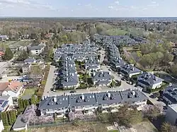 Aerial view of the neighbourhood of Wille Laguna (Lagoon Villas) and the Lipkowski Pond, located within Dąbrówka, in 2022. | |
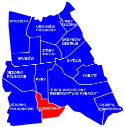 Location of Dąbrówka within the district of Mokotów, in accordance to the City Information System. | |
| Coordinates: 52°6'31"N, 21°1'34"E | |
| Country | |
| Voivodeship | Masovian Voivodeship |
| City county | Warsaw |
| District | Ursynów |
| Time zone | UTC+1 (CET) |
| • Summer (DST) | UTC+2 (CEST) |
History
First known mention of the village of Dąbrówka, then listed as Dambrowka, dates to the year 1422. By 1580, it had the status of zaścianek, a village inhabited by the petty nobility of the Kingdom of Poland, and was administratively part of the Warsaw Land, within the Masovian Voivodeship.[2]
On 5 May 1951, the village had been incorporated into the city of Warsaw.[3]
Notes
- Polish pronunciation: [dɔmˈbrufka]
References
- "Obszary MSI. Dzielnica Ursynów". zdm.waw.pl (in Polish).
- Adolf Pawiński: Polska XVI wieku pod względem geograficzno-statystycznym. vol. 5: Mazowsze, Warsaw, 1895, p. 273.
- Rozporządzenie Rady Ministrów z dnia 5 maja 1951 r. w sprawie zmiany granic miasta stołecznego Warszawy. 5 May 1951. In: 1951 Journal of Laws, Warsaw: 1951, no. 27, position 199.
This article is issued from Wikipedia. The text is licensed under Creative Commons - Attribution - Sharealike. Additional terms may apply for the media files.