Dalanzadgad
Dalanzadgad (Mongolian: Даланзадгад; ᠳᠠᠯᠠᠨᠵᠠᠳᠠᠭᠠᠳ) is the capital of Ömnögovi Aimag in Mongolia. It is located 540 kilometers (340 mi) south of the national capital Ulaanbaatar. The altitude of the city center is 1,470 meters (4,823 feet).
Dalanzadgad
Даланзадгад ᠳᠠᠯᠠᠨᠵᠠᠳᠠᠭᠠᠳ | |
|---|---|
| Dalanzadgad District Даланзадгад сум ᠳᠠᠯᠠᠨᠵᠠᠳᠠᠭᠠᠳᠰᠤᠮᠤ | |
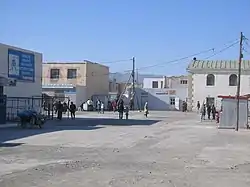 The streets of Dalanzadgad | |
 Dalanzadgad | |
| Coordinates: 43°34′N 104°26′E | |
| Country | Mongolia |
| Province | Ömnögovi Province |
| Government | The Office of the Dalanzadgad City Governor |
| Area | |
| • Total | 476 km2 (184 sq mi) |
| Elevation | 1,470 m (4,820 ft) |
| Population (2017) | |
| • Total | 24,863 |
| • Density | 52/km2 (140/sq mi) |
| Time zone | UTC+8 (UTC + 8) |
| Postal code of SouthGobi | 64000 |
As of 2011, its population is 19,396.[1]
Transportation
The Dalanzadgad Airport (ZMDZ/DLZ) is served by regular domestic flights from and to Ulaanbaatar. There are summer and winter timetables.
In 2007, the Mongolian Civil Aviation Authority built a new airport with a paved runway. The runway is second longest in the country after Buyant-Ukhaa International Airport. Before that, the airport had only one gravel runway.
The Dalanzadgad town has a paved road connecting it with capital Ulaanbaatar city.[2]
Gallery
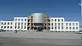 Provincial Government Building.
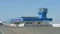 Dalanzadgad Airport.
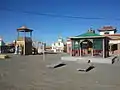 Temple.
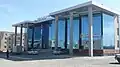 Gandirs Shopping center.
 The old Khan Bank.
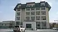 Hotel Dalanzadgad.
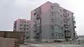 Apartment buildings.
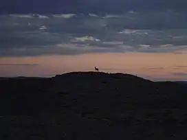
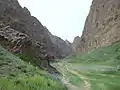 Steppe micro-climate in nearby Yolyn Am.
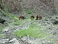 Steppe micro-climate in Yolyn Am.
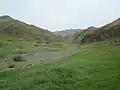 Steppe micro-climate in Yolyn Am.
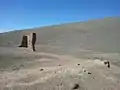 Monastery ruins near Dalanzadgad.
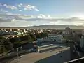 Dalanzadgad half-panorama.
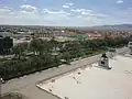 Dalanzadgad half-panorama.
Climate
Dalanzadgad experiences a cold desert climate (Köppen BWk) with cold winters and warm summers. By Mongolian standards it is one of the warmest places in the country during winter. Along with Tsetserleg and Arvaikheer it was warmer than Hohhot in January 2014 and 2015.[3] A unique steppe micro-climate with running streams and lush grass can be found in the nearby Yolyn Am valley.
| Climate data for Dalanzadgad (1991-2020, extremes 1936-present) | |||||||||||||
|---|---|---|---|---|---|---|---|---|---|---|---|---|---|
| Month | Jan | Feb | Mar | Apr | May | Jun | Jul | Aug | Sep | Oct | Nov | Dec | Year |
| Record high °C (°F) | 9.4 (48.9) |
14.7 (58.5) |
21.9 (71.4) |
30.7 (87.3) |
33.8 (92.8) |
37.4 (99.3) |
39.9 (103.8) |
37.5 (99.5) |
33.0 (91.4) |
29.0 (84.2) |
18.9 (66.0) |
13.6 (56.5) |
39.9 (103.8) |
| Average high °C (°F) | −7.1 (19.2) |
−2.1 (28.2) |
5.9 (42.6) |
14.8 (58.6) |
21.4 (70.5) |
26.7 (80.1) |
29.2 (84.6) |
27.2 (81.0) |
21.2 (70.2) |
12.5 (54.5) |
2.8 (37.0) |
−5.0 (23.0) |
12.3 (54.1) |
| Daily mean °C (°F) | −13.9 (7.0) |
−9.2 (15.4) |
−1.1 (30.0) |
8.0 (46.4) |
14.7 (58.5) |
20.4 (68.7) |
23.0 (73.4) |
21.0 (69.8) |
14.8 (58.6) |
5.8 (42.4) |
−3.9 (25.0) |
−11.7 (10.9) |
5.7 (42.2) |
| Average low °C (°F) | −19.3 (−2.7) |
−15.4 (4.3) |
−7.6 (18.3) |
−1.3 (29.7) |
8.1 (46.6) |
14.0 (57.2) |
17.1 (62.8) |
15.1 (59.2) |
8.7 (47.7) |
−0.3 (31.5) |
−9.6 (14.7) |
−17.1 (1.2) |
−0.6 (30.9) |
| Record low °C (°F) | −32.8 (−27.0) |
−31.1 (−24.0) |
−27.8 (−18.0) |
−20.0 (−4.0) |
−9.0 (15.8) |
−1.1 (30.0) |
5.4 (41.7) |
3.9 (39.0) |
−12.8 (9.0) |
−17.2 (1.0) |
−28.9 (−20.0) |
−36.1 (−33.0) |
−36.1 (−33.0) |
| Average precipitation mm (inches) | 1.6 (0.06) |
2.6 (0.10) |
3.9 (0.15) |
4.1 (0.16) |
11.4 (0.45) |
21.7 (0.85) |
33.0 (1.30) |
28.7 (1.13) |
14.5 (0.57) |
5.3 (0.21) |
3.1 (0.12) |
2.8 (0.11) |
132.7 (5.22) |
| Average precipitation days (≥ 1.0 mm) | 1.3 | 1.4 | 1.8 | 1.7 | 3.1 | 3.8 | 5.4 | 4.4 | 2.8 | 2.0 | 1.8 | 2.5 | 32.0 |
| Average relative humidity (%) | 61.0 | 51.5 | 40.3 | 32.1 | 32.0 | 36.8 | 42.4 | 43.4 | 39.0 | 41.4 | 51.1 | 59.1 | 44.2 |
| Average dew point °C (°F) | −20.5 (−4.9) |
−18.4 (−1.1) |
−14.5 (5.9) |
−9.8 (14.4) |
−4.4 (24.1) |
3.0 (37.4) |
7.7 (45.9) |
6.1 (43.0) |
−0.9 (30.4) |
−7.8 (18.0) |
−13.5 (7.7) |
−18.7 (−1.7) |
−7.6 (18.3) |
| Mean monthly sunshine hours | 262 | 221 | 253 | 264 | 316 | 304 | 291 | 299 | 279 | 268 | 233 | 229 | 3,219 |
| Source 1: Pogoda.ru.net [4] | |||||||||||||
| Source 2: NOAA, [5] Deutscher Wetterdienst (sun, 1961–1990)[6] | |||||||||||||
Communications and Power
There is GSM coverage in the city the same as in other major locations - the coverage is good for about a mile out of the city. Usually, the city is also supplied with electric power 24 hours a day. Near Dalanzadgad, at 43°31′54.38″N 104°24′4.16″E, there is a longwave broadcasting station working on 209 kHz with 75 kW.
External links
References
- Ministry of Health of Mongolia. National Center for Health Development. Health Indicators 2006 "2006" (PDF). Archived from the original (PDF) on 2007-10-25. Retrieved 2013-06-30.
- "Dalanzadgad Ulaanbaatar road is complete in September 2014". Archived from the original on 2016-03-12. Retrieved 2014-12-11.
- # Jan 2014 Climate History for Dalanzadgad, Mongolia. Weather Underground.
- КЛИМАТ УЛАН-БАТОРА (in Russian). Pogoda.ru.net. Retrieved 4 January 2015.
- "Dalanzadgad Climate Normals 1991-2020". National Oceanic and Atmospheric Administration. Retrieved August 11, 2023.
- "Station 44373 Dalanzadgad". Global station data 1961–1990—Sunshine Duration. Deutscher Wetterdienst. Archived from the original on 2017-10-17. Retrieved 6 November 2016.