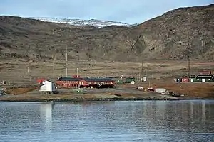
Danmarkshavn
Danmarkshavn (Denmark's Harbour) is a small weather station located in Dove Bay, on the northeastern shore of the Germania Land Peninsula, in Northeast Greenland National Park, Greenland.

History
The location was chosen as a suitable winter harbor by the Denmark expedition in 1906 for their ship Danmark. It became the main base of the expedition, from where sledge journeys and scientific observations were carried out.[1]
Description
The permanent population of the base is six. Danmarkshavn is also known as the northernmost location on the coast of the Greenland Sea that non-icebreaking vessels can pass through. Therefore, it is resupplied by cargo ship in August every other year; thus the population increases somewhat for a brief time every other August. The ice situation varies, and some years it is not possible to reach the station, other years it is ice-free further north. It is operated by TELE-POST Greenland, a telecommunications company.[2] Danmarkshavn has a short airstrip (ICAO: BGDH).
The station is jointly funded by countries that have ratified the Agreement on the Joint Financing of Certain Air Navigation Services In Greenland.[3]
 Danmarkshavn, September 2013 |
Climate
Danmarkshavn has a cold tundra climate (Köppen climate classification ET), and hence it has long, cold winters. July and August are the warmest months, with average temperatures just a few degrees above freezing.
| Climate data for Danmarkshavn (normals 1991-2020, extremes 1958-2020) | |||||||||||||
|---|---|---|---|---|---|---|---|---|---|---|---|---|---|
| Month | Jan | Feb | Mar | Apr | May | Jun | Jul | Aug | Sep | Oct | Nov | Dec | Year |
| Record high °C (°F) | 4.5 (40.1) |
2.1 (35.8) |
0.3 (32.5) |
3.8 (38.8) |
11.8 (53.2) |
17.1 (62.8) |
19.8 (67.6) |
19.7 (67.5) |
8.6 (47.5) |
4.8 (40.6) |
2.4 (36.3) |
3.8 (38.8) |
19.8 (67.6) |
| Average high °C (°F) | −17.2 (1.0) |
−18.0 (−0.4) |
−18.3 (−0.9) |
−11.8 (10.8) |
−3.4 (25.9) |
4.4 (39.9) |
7.7 (45.9) |
6.0 (42.8) |
−0.7 (30.7) |
−9.1 (15.6) |
−13.6 (7.5) |
−16.6 (2.1) |
−7.5 (18.4) |
| Daily mean °C (°F) | −21.4 (−6.5) |
−22.2 (−8.0) |
−22.2 (−8.0) |
−15.9 (3.4) |
−6.4 (20.5) |
1.5 (34.7) |
4.4 (39.9) |
3.2 (37.8) |
−2.8 (27.0) |
−11.9 (10.6) |
−17.2 (1.0) |
−20.6 (−5.1) |
−11.0 (12.3) |
| Average low °C (°F) | −25.8 (−14.4) |
−26.9 (−16.4) |
−27.0 (−16.6) |
−21.1 (−6.0) |
−9.9 (14.2) |
−1.3 (29.7) |
1.3 (34.3) |
0.3 (32.5) |
−5.4 (22.3) |
−14.8 (5.4) |
−20.8 (−5.4) |
−24.9 (−12.8) |
−14.7 (5.6) |
| Record low °C (°F) | −44.4 (−47.9) |
−43.6 (−46.5) |
−45.0 (−49.0) |
−39.3 (−38.7) |
−26.0 (−14.8) |
−12.8 (9.0) |
−7.0 (19.4) |
−8.2 (17.2) |
−17.6 (0.3) |
−31.0 (−23.8) |
−36.3 (−33.3) |
−41.1 (−42.0) |
−45.0 (−49.0) |
| Average precipitation mm (inches) | 30.9 (1.22) |
21.0 (0.83) |
21.0 (0.83) |
13.2 (0.52) |
7.7 (0.30) |
4.1 (0.16) |
13.6 (0.54) |
20.9 (0.82) |
19.7 (0.78) |
17.7 (0.70) |
19.1 (0.75) |
20.8 (0.82) |
209.7 (8.27) |
| Average precipitation days (≥ 1.0 mm) | 5.1 | 4.3 | 4.6 | 3.2 | 1.9 | 1.1 | 3.0 | 3.5 | 3.6 | 3.8 | 4.2 | 4.3 | 42.6 |
| Average relative humidity (%) | 71.9 | 69.0 | 68.9 | 69.0 | 76.9 | 77.7 | 77.5 | 76.6 | 72.7 | 71.4 | 69.5 | 68.4 | 72.5 |
| Mean monthly sunshine hours | 0 | 11 | 131 | 274 | 368 | 341 | 376 | 272 | 168 | 67 | 0 | 0 | 2,008 |
| Percent possible sunshine | 0.0 | 11.1 | 37.1 | 47.5 | 49.5 | 47.4 | 50.5 | 39.1 | 39.7 | 31.0 | 0.0 | 0.0 | 29.4 |
| Source: Danish Meteorological Institute[4][5][6][7] | |||||||||||||
References
- Georg Carl Amdrup, Report on the Danmark Expedition to the North-East Coast of Greenland 1906-1908". p. 65
- Danmarkshavn
- Danish Polar Center Archived 2007-06-06 at the Wayback Machine (Dansk Polarcenter)
- "Klimanormaler Grønland". DMI (in Danish). Retrieved 2023-03-01.
- "Climatological Standard Normals 1991-2020 Greenland" (PDF). DMI. Retrieved 2023-03-01.
- "dmi.dk". Archived from the original on 2017-09-02. Retrieved 2014-06-17.
- "04320: Danmarkshavn (Greenland)". ogimet.com. OGIMET. 28 July 2021. Retrieved 31 July 2021.