Darran Mountains
The Darran Mountains are a prominent range within New Zealand's Fiordland National Park, the country's biggest national park. They contain the park's highest peak, Mount Tūtoko (2,723 metres (8,934 ft)).
| Darran Mountains | |
|---|---|
| Highest point | |
| Elevation | 2,723 m (8,934 ft)[1] |
| Parent peak | Mount Tūtoko |
| Coordinates | 44°40′S 168°05′E |
| Geography | |
| Location | Fiordland, South Island, New Zealand |
| Geology | |
| Age of rock | |
| Type of rock | Diorite |
| Volcanic arc/belt | Zealandia Median Tectonic Zone |
| Last eruption | 136 ± 1.9 Ma[2] |
| Climbing | |
| Normal route | Homer Tunnel |
| Access | State Highway 94 (New Zealand) |
Geography
The range lies between Milford Sound (Piopiotahi) and the valley of the Cleddau River (to the west) and the broad valley of the Hollyford River to the east at the northern end of the national park. They are bounded to the south by the Homer Saddle, which separates them from the Wick Mountains, and to the north by the coast of the Tasman Sea. The Homer Tunnel lies under the southwesternmost extreme of the range.[3]
Other than Mount Tūtoko, other prominent peaks in the range include Mount Madeline and Mount Christina. Numerous lakes and tarns are found within the range, among the largest being Lake Adelaide and Lake Marian, and several rivers have their watershed in the mountains, such as the Tūtoko, Kaipo, and Bowen Rivers. The Bowen River, close to its mouth, provides one of Milford Sound's more notable natural attractions, the Bowen Falls.[3]
The mountains were named by Captain J. Stokes, an early surveyor of the West Coast of the South Island.[4]
| Peak | Height[1] | Coordinate[1] | Picture |
|---|---|---|---|
| Mount Tūtoko | 2,723 metres (8,934 ft) | 44°35′41″S 168°00′45″E | .jpg.webp) Mount Tūtoko towards the south from the Hollyford Track. |
| Mount Madeline | 2,536 metres (8,320 ft) | 44°36′51″S 168°02′45″E | |
| Mount Christina | 2,474 metres (8,117 ft) | 44°47′35″S 168°02′55″E | |
| Mount Te Wera | 2,309 metres (7,575 ft) | 44°39′30″S 168°03′15″E | |
| Mount Crosscut | 2,263 m (7,425 ft) | 44°45′50″S 168°01′51″E |  Mount Crosscut beyond Lake Marian in a view toward the northwest |
| Mount Patuki | 2,246 metres (7,369 ft) | 44°40′09″S 168°01′24″E | |
| Mount Grave | 2,225 metres (7,300 ft) | 44°35′32″S 167°57′12″E | |
| Mount Syme | 2,188 metres (7,178 ft) | 44°37′37″S 168°01′56″E | |
| Paranui Peak | 2,167 metres (7,110 ft) | 44°34′17″S 167°58′44″E | |
| Mount Gifford | 2,149 metres (7,051 ft) | 44°43′30″S 168°04′33″E | |
| Mount Tuhawaiki | 2,092 metres (6,864 ft) | 44°41′02″S 168°04′39″E | |
| Mount Pembroke | 2,015 m (6,611 ft) | 44°34′05″S 167°53′08″E | |
| Barren Peak | 1,561 m (5,121 ft) | 44°39′41″S 167°57′03″E | 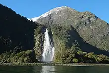 Bowen Falls from Milford Sound with Barren Peak behind. |
| Rover Peak | 1,524 m (5,000 ft) | 44°35′09″S 167°51′17″E | |
| The Lion | 1,302 m (4,272 ft) | 44°36′35″S 167°53′03″E |
Geology
The highest mountains are predominantly composed of a biotite from volcanic diorite dated to 138 ± 2.9 Ma and with younger intusion dykes of say quartz monzodiorite dated at 136 ± 1.9 Ma.[2] These rocks are part of the Median Tectonic Zone that separates the Western and Eastern provinces of Zealandia rocks. They cover an area of about 740 km2 (290 sq mi).[2] The mountains also have components to their north of rocks such as metamorphosed sandstone and gneiss from the Western Province. In the south eastern tip is found quartz diorite.[2]
Climbing
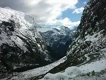
Many of the mountains have known mountain climbing routes.[5]
 The portal of Homer Tunnel is the most south western extreme of the Darran Mountains
 Mount Crosscut in view almost due north from State Highway 94 on its way towards Homer Tunnel from the east.
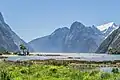 View from head of Milford Sound of some of the Darrant Mountains on the north side of sound being The Lion and beyond it Rover Peak 1,524 m (5,000 ft)[1] and snow covered Mount Pembroke 2,015 m (6,611 ft).[1]
References
- NZTopoMap:Milford Sound
- A Wandres; SD Weaver; D Shelley; JD Bradshaw (1998). "Diorites and associated intrusive and metamorphic rocks of the Darran Complex, Mount Underwood, Milford, southwest New Zealand". New Zealand Journal of Geology and Geophysics. 41 (1): 1–14. doi:10.1080/00288306.1998.9514786.
- Dowling, P. (ed.) (2004). ’’Reed New Zealand atlas’’. Auckland: Reed Publishing. Map 89. ISBN 0 7900 0952 8
- Reed, A.W. (1975). Place names of New Zealand. Wellington: A.H. & A.W. Reed. p. 99.
- "ClimbNZ:Darran Mountains (457 routes)". Retrieved 15 March 2023.