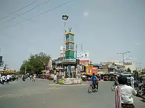
Darsi
Darsi is a municipality town in Prakasam district of the Indian state of Andhra Pradesh. Before British rule, it was also called Darshanapuri, named by an ancient Andhra king. It is the mandal headquarters of Darsi mandal in Kanigiri revenue division.[1] It is located at the foot of the Nallamala Hills. Lush, green fields surround the town. It is 20 km away from Podili and 33 km away from Addanki.
Darsi | |
|---|---|
Town | |
.svg.png.webp) Darsi Location in Andhra Pradesh, India  Darsi Darsi (India) | |
| Coordinates: 15.7667°N 79.6833°E | |
| Country | India |
| State | Andhra Pradesh |
| District | Prakasam |
| Mandal | Darsi |
| Government | |
| • Body | Darsi |
| Population (2011) | |
| • Total | 33,418 |
| Languages | |
| • Official | Telugu |
| Time zone | UTC+5:30 (IST) |
| PIN | 523247 |
| Telephone code | +91–8407 |
| Vehicle registration | AP 27 |
Geography

Darsi is located on the Addanki - Podili Road. It is at 15.7667°N 79.6833°E in the Prakasam district of Andhra Pradesh. Darsi is a town at the foot of Nallamala. It is a plain region in the coromandal region. It is covered with small mountain ranges to the north, Pulipadu Pond to the east and lush, green fields to the south and west.
Education
There are 11 public primary schools, 12 private primary schools, one government high school, 12 private high schools, three public secondary schools and three private secondary schools.
Prominent schools include:
- A.P. Model School
- Kijiji High School
- Gowthami Grammar School
- Sri Chaitanya School
Places To Visit
- NAP pond near Darsi Hills
- Sai Baba temple near Pulipadu Lake
- Venkateswara Swami temple
- Skj power project
- Darsi Pallevanam Park
- Clock Tower
Assembly constituency
Darsi is an assembly constituency in Andhra Pradesh, one of 12 in Prakasam district. In the last elections, YSRCP (YSR Congress) candidate Maddisetti Venugopal won by a margin of 39057 votes on Kadiri Babu Rao. Dirisala Ramanareddy was the first chairman of Prakasam Zilla Parishad in 1970. Budamaguntla Balaiah was elected as Mandal Parishad President (M.P.P) in the year 1996.
Water source
The town people mostly depend on Nagarjunasagar Right Canal (Jawahar canal) for both irrigation & drinking. It passes through Darsi. The town receives rainfall between mid-July to September. There is also a fresh water lake built by the Netherlands' Government.
Transport
There is a bus station in Darsi near where the Podili Road, Kurichedu Road and Lankojanapalli Road intersect. There is also a bus station in Auto Nagar, Darsi.[2] From there, other depot buses go to nearby towns and cities including Ongole and Podili, but also cities further away like Hyderabad, Karimnagar and Bengaluru.[3] The railway line, Nadikudi-Srikalahasthi will pass when it finishes construction through the town. It is also well connected by road.
References
- "Prakasam District Mandals" (PDF). Census of India. pp. 132, 173. Retrieved 19 June 2015.
- "Darsi Bus Station".
- onefivenine.com