City of Darwin
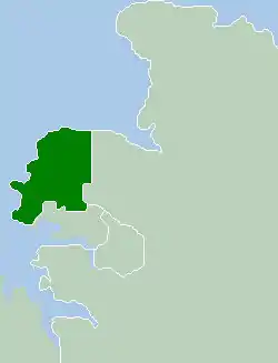
The City of Darwin is a local government area of the Northern Territory, Australia. It includes the central business district of the capital, Darwin City, and represents two-thirds of its metropolitan population. The City covers an area of 111 square kilometres (43 sq mi) and, in June 2018, had a population of 84,613 people.[1]
| City of Darwin Northern Territory | |
|---|---|
 | |
| Population | 84,613 (2018)[1] |
| • Density | 762/km2 (1,974/sq mi) |
| Established | 1959 |
| Area | 111 km2 (42.9 sq mi)[1] |
| Mayor | Kon Vatskalis (Labor) |
| Council seat | Darwin City |
| Region | Metropolitan Darwin |
| Territory electorate(s) | Casuarina, Fannie Bay, Fong Lim, Johnston, Karama, Nightcliff, Port Darwin, Sanderson, Spillett, Wanguri |
| Federal division(s) | Solomon |
| Website | City of Darwin |
| Footnotes | Adjoining LGAs[2] |
History
The first Town and District Council was formed in 1874. The Darwin Town Council was created in 1915. From 1921 the five member Council had been elected on a ratepayer's franchise. In 1930 the Mayor and councillors resigned in protest against the re-introduction of adult suffrage. A caretaker Council was appointed until 1937, when it was abolished at the council's own request.
In 1955 a statement added to the Local Government Ordinance provided for the Constitution of the Municipality of Darwin. In 1957 the council was increased to twelve members and a Mayor.
An annual election providing for the Mayor and half of the Council members to be retired at each election, was also introduced at this time. The first council elections were held on 29 June 1957 and the first elected mayor of Darwin was Lucius (Bill) Richardson.[3] In 1959 an Ordinance provided that the Municipality of Darwin be constituted a city and named 'City of Darwin'.
The first female Mayor of Darwin was Dr Ella Stack, who served as the Mayor of Darwin from May 1975 to November 1979, and as Darwin's first Lord Mayor from November 1979.[3]
Wards and councillors
City of Darwin is divided into four wards, governed by 12 Councillors across those wards, as well as one directly elected Lord Mayor. Councillors from each ward are elected using a Single Transferable Vote (STV) proportional system.[4]
| Wards and councillors[5] | ||||
|---|---|---|---|---|
| Ward | Councillor | Party | Notes | |
| Chan | Peter Pangquee | Independent | ||
| Morgan Rickard | Greens | [6] | ||
| Ed Smelt | Independent | |||
| Lyons | Mick Palmer | Independent | ||
| Amye Un | Independent | |||
| Richardson | Jimmy Bouhoris | Independent | ||
| Vim Sharma | Independent | |||
| Rebecca Want de Rowe | Labor | |||
| Waters | Kim Farrar | Independent | ||
| Brian O'Gallagher | Country Liberal | [7] | ||
| Sylvia Klonaris | Independent | |||
Suburbs
| Chan Ward (west) |
Lyons Ward (south) |
Richardson Ward (north) |
Waters Ward (east) |
Suburb Map |
|---|---|---|---|---|
|
|
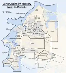 |
Most of the suburb of Charles Darwin which is largely occupied by the Charles Darwin National Park reaches outside of the boundaries of the City of Darwin into unincorporated area, as do large parts of Berrimah and Hidden Valley. The last two suburbs, Buffalo Creek and Holmes, were approved in 2007. They are still largely undeveloped, especially Buffalo Creek.
Demographics
| Selected historical census data for City of Darwin local government area | ||||||
|---|---|---|---|---|---|---|
| Census year | 2001[9] | 2006[10] | 2011[11] | 2016[12] | ||
| Population | Estimated residents on census night | 69,455 | 66,291 | 72,930 | 78,804 | |
| LGA rank in terms of size within Northern Territory | 1st | |||||
| % of Northern Territory population | 34.26% | |||||
| % of Australian population | 0.37% | |||||
| Cultural and language diversity | ||||||
| Ancestry, top responses | Australian | 24.1% | ||||
| English | 20.7% | |||||
| Irish | 7.2% | |||||
| Scottish | 5.7% | |||||
| Chinese | 3.6% | |||||
| Language, top responses (other than English) | Greek | 3.5% | ||||
| Tagalog | 1.0% | |||||
| Cantonese | 1.0% | |||||
| Italian | 0.8% | |||||
| Hakka | 0.8% | |||||
| Indonesian | 0.9% | |||||
| Mandarin | 1.3% | |||||
| Filipino | 1.0% | |||||
| Nepali | 1.2% | |||||
| Religious affiliation | ||||||
| Religious affiliation, top responses | Catholic | 25.4% | ||||
| No religion | 20.5% | |||||
| Anglican | 14.5% | |||||
| Uniting | 6.5% | |||||
| Eastern Orthodox | 4.3% | |||||
| Median weekly incomes | ||||||
| Personal income | Median weekly personal income | A$687 | A$899 | A$1039 | ||
| % of Australian median income | 147.4% | 155.8% | 157.0% | |||
| Family income | Median weekly family income | A$1524 | A$2063 | A$2385 | ||
| % of Australian median income | 130.2% | 139.2% | 137.5% | |||
| Household income | Median weekly household income | A$1286 | A$1809 | A$2164 | ||
| % of Australian median income | 125.2% | 146.6% | 150.5% | |||
| Dwelling structure | ||||||
| Dwelling type | Separate house | 55.3% | ||||
| Semi-detached, terrace or townhouse | 13.2% | 11.9% | ||||
| Flat or apartment | 23.8% | |||||
Sister cities
The city of Darwin has seven sister cities.[13]
| City | State | Country | Year |
|---|---|---|---|
| Kalymnos | South Aegean region | Greece | April 1982 |
| Anchorage | Alaska | United States | July 1982 |
| Ambon | Maluku | Indonesia | October 1988 |
| Haikou | Hainan | China | September 1990 |
| Milikapiti | Northern Territory | Australia | July 1999 |
| Dili | Dili District | East Timor | September 2003 |
| Bacolod | Negros Occidental | Philippines | August 2022 |
References
- "3218.0 – Regional Population Growth, Australia, 2017-18: Population Estimates by Local Government Area (ASGS 2018), 2017 to 2018". Australian Bureau of Statistics. Australian Bureau of Statistics. 27 March 2019. Retrieved 25 October 2019. Estimated resident population, 30 June 2018.
- "Litchfield Municipality Localities (map)" (PDF). Northern Territory Government. 29 October 1997. Archived from the original (PDF) on 18 March 2019. Retrieved 16 May 2019.
A document re the Litchfield Municipality has been cited because it is a map which depicts the relationship of the City of Darwin to its surroundings.
- "History". City of Darwin. City of Darwin. 2019. Retrieved 5 December 2019.
- "Archived copy" (PDF). Archived from the original (PDF) on 14 March 2016. Retrieved 28 April 2016.
{{cite web}}: CS1 maint: archived copy as title (link) - https://www.darwin.nt.gov.au/council/about-council/lord-mayor-councillors
- https://greens.org.au/nt/person/morgan-rickard
- https://www.ntnews.com.au/news/politics/election-posters-for-clp-karama-candidate-brian-ogallagher-set-alight-threatening-suburban-home/news-story/b3062a872bfd2b14ba92e9842ff39279?amp
- Darwin City Council - Compiled Plan
- Australian Bureau of Statistics (9 March 2006). "City of Darwin (C)". 2001 Census QuickStats. Retrieved 6 December 2017.
- Australian Bureau of Statistics (25 October 2007). "City of Darwin (C)". 2006 Census QuickStats. Retrieved 6 December 2017.
- Australian Bureau of Statistics (31 October 2012). "City of Darwin (C)". 2011 Census QuickStats. Retrieved 6 December 2017.
- Australian Bureau of Statistics (27 June 2017). "Darwin (C) (Local Government Area)". 2016 Census QuickStats. Retrieved 28 June 2017.
- "Darwin's Sister Cities". Darwin City Council. Archived from the original on 18 February 2011. Retrieved 18 September 2010.