Despreux River
The Despreux River is a tributary of the Harricana River, flowing into the municipalities of Eeyou Istchee Baie-James (municipality), in Jamésie, in the administrative region from Nord-du-Québec, in Quebec, in Canada.
| Despreux | |
|---|---|
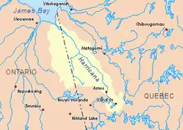 Harricana River basin in yellow | |
| Location | |
| Country | Canada |
| Province | Quebec |
| Region | Nord-du-Québec |
| Physical characteristics | |
| Source | |
| • location | Eeyou Istchee Baie-James (municipality), Nord-du-Québec, Quebec |
| • coordinates | 50°10′32″N 79°04′53″W |
| • elevation | 261 m (856 ft) |
| Mouth | Harricana River |
• location | Eeyou Istchee Baie-James (municipality), Nord-du-Québec, Quebec |
• coordinates | 50°30′54″N 79°08′14″W |
• elevation | 97 m (318 ft) |
| Length | 44.7 km (27.8 mi)[1] |
The surface of the river is usually frozen from early November to mid-May, however, safe ice movement is generally from mid-November to the end of April.
Geography
The main hydrographic slopes near the Despreux River are:
- North side: Breynat River, Harricana River, Joncas River;
- East side: Harricana River, Joncas River;
- South side: Turgeon River (Eeyou Istchee James Bay), Martigny River;
- West side: Breynat River, Malouin River, Mannerelle River.
The Despreux River derives its source from a forest stream (elevation: 261 metres (856 ft)), located in the municipality of Eeyou Istchee James Bay (municipality).
The source of the Despreux River located at:
- 8.5 kilometres (5.3 mi) West of the Harricana River;
- 15.1 kilometres (9.4 mi) East of the source of the Malouin River;
- 30.5 kilometres (19.0 mi) East of the Ontario border.
From the source, the Despreux River flows over 44.7 kilometres (27.8 mi) according to the following segments:
- 15.4 kilometres (9.6 mi) north, to the dump (coming from the South-East) of Lake Despreux;
- 24.9 kilometres (15.5 mi) to the North, to a creek (coming from the South);
- 4.4 kilometres (2.7 mi) northeasterly to mouth.[2]
The Despreux River flows on the west bank of the Harricana River across the Island of Seven Mile, to:
- 88.6 kilometres (55.1 mi) South-East of the mouth of the Harricana River;
- 26.9 kilometres (16.7 mi) East of the Ontario border;
- 136 kilometres (85 mi) North-West of downtown Matagami, Quebec.
Toponymy
The toponym "Despreux River" was formalized on December 5, 1968, at the Commission de toponymie du Québec, when it was founded.[3]
Notes and references
- Atlas of Canada
- Distances from the Department of Natural Resources Canada's Atlas of Canada (published on the Internet).
- Commission de toponymie du Quebec - Bank of Place Names - Toponym: "Despreux River"