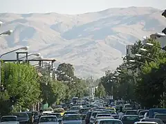
Salmas
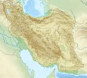
Salmas (Persian: سلماس; Armenian: Սալմաստ; Azerbaijani: سلماس; Kurdish: سەڵماس; Syriac: ܣܵܠܵܡܵܣ, romanized: Salamas[3]) is a city in the Central District of Salmas County, West Azerbaijan province, Iran, and serves as capital of the county. It is located northwest of Lake Urmia, near Turkey.[4]
Salmas
سلماس | |
|---|---|
City | |
| Salmas | |
 | |
| Nickname(s): Dilmagān/Dilman (historic), Shapur | |
 Salmas | |
| Coordinates: 38°12′06″N 44°46′07″E[1] | |
| Country | Iran |
| Province | West Azerbaijan |
| County | Salmas |
| District | Central |
| Earliest Recognition | 224–242 AD |
| Rebuilt | 1930 |
| Government | |
| • Type | Mayor–Council |
| • Body | Salmas |
| • Mayor | N/A |
| Area | |
| • Total | 9.26 sq mi (24.0 km2) |
| • Land | 9.26 sq mi (24.0 km2) |
| • Water | 0 sq mi (0 km2) |
| • Metro | 4.75 sq mi (12.3 km2) |
| Elevation | 4,532 ft (1,381 m) |
| Population (2016)[2] | |
| • Total | 92,811 |
| • Rank | TBA, Iran |
| • Density | 10,000/sq mi (3,900/km2) |
| Demonym(s) | Salmasi, Salmassi |
| Time zone | UTC+3:30 (IRST) |
| ZIP code | 58811 ≤ 58XXX ≤ 58991 |
| Area code | 44 |
At the 2006 census, its population was 79,560 in 19,806 households.[5] The following census in 2011 counted 88,196 people in 23,751 households.[6] The latest census in 2016 showed a population of 92,811 people in 27,115 households.[2] According to the 2019 census, the city's population is 127,864.[7] The majority of the population is composed of Azerbaijanis and Kurds[8] with some Armenians, Assyrians, and Jews.[9]
Name
The original name of Salmas was Dilman, which is probably related to the Daylamites who sometimes controlled the region. In the 19th-century, it was known as Shapur.[10]
History
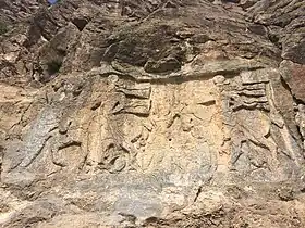
Salmas's archaeological relics, which date as far back as the Urartian kingdom (860 BC–590 BC), attest to its long human habitation.[10] Salmas was part of the Armenian province of Nor Shirakan (also known as Persarmenia),[10][11] which was inhabited by Armenians.[11] A rock relief erected during the reign of the Sasanian monarch Ardashir I (r. 224–242) is located in the Khan-Takhti village near Salmas. This rock relief illustrates two akin scenarios in which a standing man receives a ring from a man riding a horse.[12]
The standing men's names are subject to interpretation, but the horsemen are typically considered to be Ardashir I and his son and heir, Shapur I. The German orientalist Ferdinand Justi (died 1907) theorized that the relief is meant to show the Armenians' gratitude to Ardashir I and Shapur I, something which some later scholars supported. The Iranologist Ehsan Shavarebi considers this theory to be "logical" but stresses that "we need more investigations on the event depicted on the relief." He suggests that the rock relief is meant to illustrate the probable peace made between Ardashir I and the Kingdom of Armenia.[12] When the Arsacid house of Armenia was abolished and the country was made a Sasanian province in 428, Nor Shirakan and Paytakaran were incorporated into the Sasanian province of Adurbadagan.[13]
Two archeological sites showing inhabitation during the Sasanian era has been found near Salmas. One of them is known as Haftan Tepe, which contains Sasanian-era pottery akin to those found in Takht-e Soleyman. The other is called Qazun Basi, located to the south of Salmas. They were likely used as military and administrative hubs.[14]
Salmas was held by the Kurdish Rawadid dynasty and frequented by the Hadhabani tribe in the 10-11th centuries. Al-Maqdisi described it as a Kurdish town who had built a wall around the city.[15][4]
Another Mention of the city was made in 1281, when its Assyrian bishop made the trip to the consecration of the Assyrian Church of the East patriarch Yaballaha in Baghdad.[16]
In the Battle of Salmas on 17–18 September 1429, the Kara Koyunlu were defeated by Shah Rukh who was consolidating Timurid holdings west of Lake Urmia.[17] However, the area was retaken by the Kara Koyunlu in 1447 after the death of Shah Rukh.
In March 1915 Cevdet Bey ordered 800 Assyrians of Salmas to be killed.[18] Mar Shimun, the Patriarch of the Assyrian Church of the East was murdered by the Kurdish chieftain Simko Shikak in Salmas in March 1918.[19][20][21]
Around the advent of the 1910s, Imperial Russia started to station infantry and Cossacks in Salmas.[22] The Russians retreated at the time of Enver Pasha's offensive in the Iran-Caucasus region, but returned in early 1916, and stayed up to the wake of the Russian Revolution.[22]
Geography
Salmas in early atlases
The atlases below are some of the earliest maps to have been ever sketched to show the territory and originality of the name of Salmas and are some of the strongest documents providing proofs to some basic facts about the city including its existence and identity.
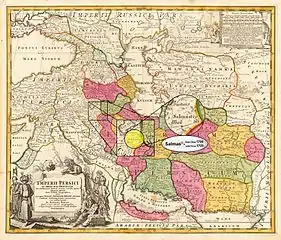 Salmas in 1724[23] Homann Map of "Persian Empire" at the Time of Safavid dynasty • Modified by Hassan Jahangiri
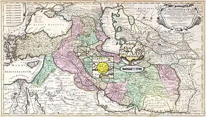 Salmas in 1730 Reiner and Joshua Ottens Map of the "Persian Empire" at the Time of Safavid dynasty • Modified by Hassan Jahangiri
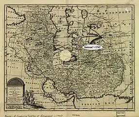 Salmas in 1747 Bowen Map of the "Persian Empire" at the Time of Afsharid dynasty • Modified by Hassan Jahangiri
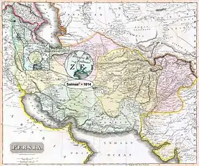 Salmas in 1814 Thomson Map of the "Persian Empire" at the Time of Qajar dynasty • Modified by Hassan Jahangiri
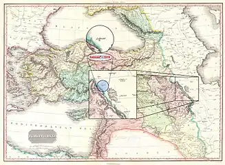 Salmas in 1818 Pinkerton Map of "Turkey in Asia, Iraq, Syria, and Palestine" (Concurred with the Time of Qajar dynasty) • Modified by Hassan Jahangiri
Climate
Under the Köppen climate classification, using the 0 °C (32 °F) isotherm, Salmas features a continental climate (Dsa), and is thus one of the few cities in the Middle East and one of the 6 in the country with this categorization.
| Climate data for Salmas (Weather Station Located in Khoy Airport) [1987-2017] | |||||||||||||
|---|---|---|---|---|---|---|---|---|---|---|---|---|---|
| Month | Jan | Feb | Mar | Apr | May | Jun | Jul | Aug | Sep | Oct | Nov | Dec | Year |
| Record high °F (°C) | 49 (9) |
61 (16) |
73 (23) |
90 (32) |
92 (33) |
99 (37) |
106 (41) |
109 (43) |
102 (39) |
93 (34) |
74 (23) |
67 (19) |
109 (43) |
| Average high °F (°C) | 30.6 (−0.8) |
34.0 (1.1) |
45.3 (7.4) |
58.1 (14.5) |
68.4 (20.2) |
78.4 (25.8) |
86.9 (30.5) |
86.4 (30.2) |
79.0 (26.1) |
64.8 (18.2) |
50.9 (10.5) |
37.0 (2.8) |
60.0 (15.5) |
| Daily mean °F (°C) | 21.6 (−5.8) |
24.6 (−4.1) |
36.1 (2.3) |
48.0 (8.9) |
56.8 (13.8) |
65.1 (18.4) |
73.0 (22.8) |
72.1 (22.3) |
64.6 (18.1) |
52.7 (11.5) |
40.6 (4.8) |
28.4 (−2.0) |
48.6 (9.2) |
| Average low °F (°C) | 12.7 (−10.7) |
14.9 (−9.5) |
26.6 (−3.0) |
37.4 (3.0) |
44.8 (7.1) |
51.1 (10.6) |
58.6 (14.8) |
57.6 (14.2) |
49.1 (9.5) |
40.3 (4.6) |
30.4 (−0.9) |
20.1 (−6.6) |
37.0 (2.8) |
| Record low °F (°C) | −18 (−28) |
−21 (−29) |
−17 (−27) |
−8 (−22) |
13 (−11) |
40 (4) |
52 (11) |
47 (8) |
37 (3) |
20 (−7) |
−7 (−22) |
−17 (−27) |
−21 (−29) |
| Average rainfall inches (mm) | 1.22 (31) |
1.45 (37) |
2.07 (53) |
3.54 (90) |
6.47 (164) |
4.84 (123) |
2.44 (62) |
1.71 (43) |
2.13 (54) |
2.2 (56) |
1.54 (39) |
1.22 (31) |
30.83 (783) |
| Average snowfall inches (cm) | 3.45 (8.8) |
2.35 (6.0) |
2.32 (5.9) |
0 (0) |
0 (0) |
0 (0) |
0 (0) |
0 (0) |
0 (0) |
0 (0) |
0 (0) |
1.96 (5.0) |
10.08 (25.7) |
| Average rainy days | 7.9 | 9.1 | 11.8 | 12 | 13.1 | 8.4 | 3.9 | 3.3 | 5.3 | 5.9 | 6.5 | 7.3 | 94.5 |
| Average snowy days | 2.75 | 2.25 | 1.75 | 0 | 0 | 0 | 0 | 0 | 0 | 0 | 0 | 2.25 | 9 |
| Average relative humidity (%) | 75.0 | 64.3 | 55.8 | 48.6 | 43.3 | 38.4 | 37.0 | 36.0 | 39.8 | 47.0 | 52.9 | 66.4 | 50.4 |
| Mean monthly sunshine hours | 147.6 | 202.8 | 239.8 | 311.2 | 352.6 | 343.4 | 356.3 | 355.6 | 276.9 | 202.6 | 150.8 | 153.2 | 3,092.8 |
| Source: "Weather Trends 360".[24] Weatherbase[25] "World Weather Online".[26] | |||||||||||||
| Year | Population | ±% |
|---|---|---|
| 1930 | ~8000 | — |
| 1934 | ~7000 | — |
| 1956 | 13,161 | — |
| 1966 | 21,703 | +64.9% |
| 1976 | 27,638 | +27.3% |
| 1986 | 50,573 | +83.0% |
| 1996 | 65,416 | +29.3% |
| 2006 | 89,617 | +37.0% |
| 2011 | 97,060 | +8.3% |
| 2016 | 101,441 | +4.5% |
| 2021 | N/A | — |
| Note: The data presented of 1976 and earlier (1956–1976) are from the censuses before Iranian Revolution and the data of 1986 and later (1986–2016) are from the censuses after it. The data for the years 1920 and 1924 are not of any censuses. Sources: "Population and Housing Census". Statistical Center of Iran. (used for censuses of 2006 and later), "An Analysis to the Urban System of West Azerbaijan Province During the Years 1956 till 2006". Urban Ecology Researches. (used for censuses of 1996 and earlier; the amounts are obtained from the data given in "Real Population" columns!), "Location and Geography of the City". Salmas County Municipality. (used for data of the years 1920 and 1924) | ||
Notable people
- Stepanos V of Salmast (d. 1567) – Catholicos of the Armenian Apostolic Church
- Yohannan Gabriel (1758–1833) – Chaldean Catholic bishop of Salmas
- Nicholas I Zaya (d. 1855) – Patriarch of Babylon of the Chaldeans
- Raffi (1835–1888) – Armenian novelist
- Paul Bedjan (1838–1920) – Chaldean Catholic priest and orientalist
- Abraham Guloyan (1893–1983) – Politician
- Murad Kostanyan (1902–1989) – Actor
- Hossein Sadaghiani (1903-1982) - The first ever manager and head coach of Iran national football team (1941-1951) and the first ever Iranian soccer player to play for foreign clubs (R. Charleroi S.C. and Fenerbahce SK) and in a European league
- Ardeshir Ovanessian (c. 1905–1990) – Communist leader
- Timur Lakestani (1915–2011) – aka Father of Iranian Electrical Industry
- Jafar Salmasi (1918–2000) – weightlifter
- Emmanuel Agassi (1930–2021) – boxer and father of Andre Agassi
- Hadi Asghari (b. 1981) – football player
Gallery
- Overall View of Imam St. and Shahrdari Sq.
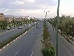
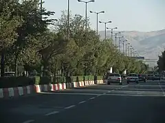 Islamic Republic Blvd., Near Panahi Technical School
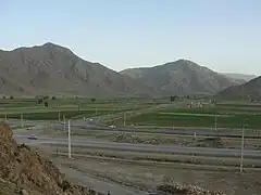 Khan Takhti-Rd near Salmas
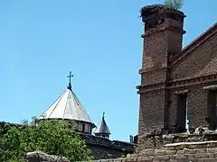 The Haftvan Church
 Chaldean Catholic Church in Salmas
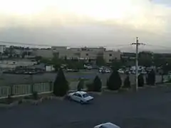
 Salmas
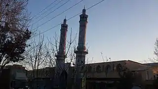 An angled front view of Salmas Imam Khomeini Prayer House, 2017
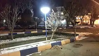 A view of Nation Park in a Winter night, 2016
References
- OpenStreetMap contributors (8 March 2023). "Salmas, Salmas County" (Map). OpenStreetMap. Retrieved 8 March 2023.
- "Census of the Islamic Republic of Iran, 1395 (2016)". AMAR (in Persian). The Statistical Center of Iran. p. 04. Archived from the original (Excel) on 30 August 2022. Retrieved 19 December 2022.
- "List of all entries". Assyrian Languages. Retrieved 14 March 2020.
- Bosworth, C. E. (2012). "Salmās". Encyclopedia of Islam. doi:10.1163/1573-3912_islam_SIM_6560.
- "Census of the Islamic Republic of Iran, 1385 (2006)". AMAR (in Persian). The Statistical Center of Iran. p. 04. Archived from the original (Excel) on 20 September 2011. Retrieved 25 September 2022.
- "Census of the Islamic Republic of Iran, 1390 (2011)" (Excel). Iran Data Portal (in Persian). The Statistical Center of Iran. p. 04. Retrieved 19 December 2022.
- "2016 Population and Housing Census". Statistical Center of Iran. Retrieved 20 May 2017.
- "..:: شهرداری سلماس ::". Archived from the original on 26 December 2014. Retrieved 26 December 2014.
- http://thegraduatesocietyla.org/images/author-padia-others.pdf
- Bosworth 1995.
- Ghodrat-Dizaji 2010, p. 75.
- Shavarebi 2014, p. 115.
- Shahinyan 2016, pp. 194–195.
- Ghodrat-Dizaji 2007, p. 90.
- Potts, D.T. Nomadism in Iran: From Antiquity to the Modern Era. New York: Oxford University Press, 2014.
- Houtsma, M. Th. et al. (1993 reprint) "Salmas" E. J. Brill's First Encyclopaedia of Islam, 1913–1936 Volume 4, E.J. Brill, New York, page 118, ISBN 90-04-09796-1
- Houtsma, M. Th. et al. (1993 reprint) "Tabrīz" E. J. Brill's First Encyclopaedia of Islam, 1913–1936 Volume 4, E.J. Brill, New York, page 588, ISBN 90-04-09796-1
- Yuhanon, B. Beth. "The Methods of Killing in the Assyrian Genocide". Sayfo 1915. p. 183. doi:10.31826/9781463239961-013. S2CID 198820452.
- Brill, E. J. (1993). E.J. Brill's First Encyclopaedia of Islam: 1913-1936. S - Ṭaiba. BRILL. ISBN 978-90-04-09793-3.
- O'Shea, Maria T. (2004) "Trapped Between the Map and Reality: Geography and Perceptions of Kurdistan Routledge, New York, page 100, ISBN 0-415-94766-9
- Nisan, Mordechai (2002) Minorities in the Middle East: A History of Struggle and Self-Expression (2nd edition) McFarland, Jefferson, North Carolina, page 187, ISBN 0-7864-1375-1
- Atabaki 2006, p. 70.
- "Imperii Persici in omnes suas provincias nova tabula geographica". Library of Congress.
- "Weather Trends 360". Weather Trends International, Inc. Retrieved 26 February 2017.
- "Salmas, Iran". Weatherbase. Retrieved 6 December 2020.
- "World Weather Online". Data provided by WorldWeatherOnline.com. Retrieved 6 June 2017.
Sources
- Atabaki, Touraj (2006). Iran and the First World War: Battleground of the Great Powers. I.B.Tauris. ISBN 978-1860649646.
- Bosworth, C.E. (1995). "Salmās". In Bosworth, C. E.; van Donzel, E.; Heinrichs, W. P. & Lecomte, G. (eds.). Encyclopaedia of Islam. Volume VIII: Ned–Sam (2nd ed.). Leiden: E. J. Brill. ISBN 978-90-04-09834-3.
- Ghodrat-Dizaji, Mehrdad (2007). "Administrative Geography of the Early Sasanian Period: The Case of Ādurbādagān". Iran: Journal of the British Institute of Persian Studies. 45 (1): 87–93. doi:10.1080/05786967.2007.11864720. S2CID 133088896.
- Ghodrat-Dizaji, Mehrdad (2010). "Ādurbādagān during the Late Sasanian Period: A Study in Administrative Geography". Iran: Journal of the British Institute of Persian Studies. 48 (1): 69–80. doi:10.1080/05786967.2010.11864774. S2CID 163839498.
- Shahinyan, Arsen (2016). "Northern Territories of the Sasanian Atropatene and the Arab Azerbaijan". Iran and the Caucasus. 20 (2): 191–203. doi:10.1163/1573384X-20160203.
- Shavarebi, Ehsan (2014). "A Reinterpretation of the Sasanian Relief at Salmās". Iran and the Caucasus. Brill. 18 (2): 115–133. doi:10.1163/1573384X-20140203.
External links
West Azerbaijan province, Iran | ||
|---|---|---|
| Capital |  | |
| Counties and cities | ||
| Tourism | ||
| Places | ||