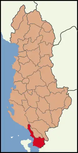
Sarandë District
Sarandë District (Albanian: Rrethi i Sarandës) was one of the 36 districts of Albania, which were dissolved in July 2000 and replaced by 12 newly created counties. It had a population of 35,235 in 2001, and an area of 730 km2 (280 sq mi).[1] The centre of the district was the city of Sarandë. Other places included Konispol (at the border with Greece), Ksamil (a resort), Çukë, Vrinë and Butrint (an archeological site). Its territory is now part of Vlorë County: the municipalities of Sarandë, Konispol, Finiq (partly) and Himara (partly).
Sarandë District | |
|---|---|
 | |
| Coordinates: 39°49′N 20°7′E | |
| Country | |
| Dissolved | 2000 |
| Seat | Sarandë |
| Area | |
| • Total | 730 km2 (280 sq mi) |
| Population (2001) | |
| • Total | 35,235 |
| • Density | 48/km2 (130/sq mi) |
| Time zone | UTC+1 (CET) |
| • Summer (DST) | UTC+2 (CEST) |

Alongside ethnic Albanians, there is a considerable ethnic Greek minority.[2][3] As of 2002, less than 30% of the inhabitants of the district were Greeks.[4]
Administrative divisions
The district consisted of the following municipalities:[5]
Communities and settlements
- Sarandë
- Shkallë
- Mursi
- Vrinë
- Xarrë
- Vervë
- Leshnicë e Poshtme
References
- Districts of Albania, statoids.com
- http://mondediplo.com/maps/albanianmdv1999 The Albanians, a scattered people by Philippe Rekacewicz, Le Monde diplomatique, January 1999
- "Country Studies US: Greeks and Other Minorities". Retrieved September 6, 2006.
- de Soto, Hermine (2002). Poverty in Albania: A Qualitative Assessment. World Bank Publications. p. 3. ISBN 9780821351093.
- "Portraits of poverty and inequality in Albania" (PDF). World Bank Group. 2016. pp. 33–40.
Further reading
- Kallivretakis, Leonidas (1995). "Η ελληνική κοινότητα της Αλβανίας υπό το πρίσμα της ιστορικής γεωγραφίας και δημογραφίας [The Greek Community of Albania in terms of historical geography and demography]". In Veremis, Thanos (ed.). Ο Ελληνισμός της Αλβανίας [The Greeks of Albania]. University of Athens. pp. 25–58. ISBN 9600800545.