List of districts of Goa
The Indian state of Goa is divided into two districts: North Goa and South Goa.
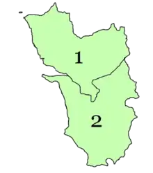
Map of districts of Goa
1. North Goa
2. South Goa
1. North Goa
2. South Goa
Administrative structure
North Goa is further divided into three subdivisions — Panaji, Mapusa, and Bicholim; and five talukas — Tiswadi (Panaji), Bardez (Mapusa), Pernem, Bicholim, and Sattari (Valpoi), South Goa is further divided into five subdivisions — Ponda, Mormugao (Vasco da Gama), Margao, Quepem, and Dharbandora; and seven talukas — Ponda, Mormugao, Salcete (Margao), Quepem, and Canacona (Chaudi), Sanguem, and Dharbandora. (Ponda taluka shifted from North Goa to South Goa in January 2015).
Districts
| Code[1] | District | Headquarters | Population (2011)[2] | Area (km²) | Density (/km²) | Official website |
| NG | North Goa (उत्तर गोवा) | Panaji (पणजी) | 817,761 | 1,736 | 471 | https://northgoa.gov.in/ |
| SG | South Goa (दक्षिण गोवा) | Madgaon (मडगांव) | 639,962 | 1,966 | 326 | https://southgoa.nic.in/ |
References
- "NIC Policy on format of e-mail Address: Appendix (2): Districts Abbreviations as per ISO 3166–2" (PDF). Ministry Of Communications and Information Technology, Government of India. 2004-08-18. pp. 5–10. Archived from the original (PDF) on 2008-09-11. Retrieved 2012-11-27.
- "Distribution of Population, Decadal Growth Rate, Sex-Ratio and Population Density" (XLS). The Registrar General & Census Commissioner, India, New Delhi-110011. 2010–2011. Retrieved 2012-08-22.
External links
Wikimedia Commons has media related to Districts of Goa.
| History | |||||||
|---|---|---|---|---|---|---|---|
| Government | |||||||
| Geography |
| ||||||
| Districts | |||||||
| Talukas | |||||||
| Cities | |||||||
| Heritage sites | |||||||
| Wildlife sanctuaries | |||||||
| Education |
| ||||||
| Science | |||||||
| Culture | |||||||
| Sports |
| ||||||
| Transport | |||||||
| |||||||
This article is issued from Wikipedia. The text is licensed under Creative Commons - Attribution - Sharealike. Additional terms may apply for the media files.