Dok Mai, Bangkok
Dok Mai also written as Dokmai (Thai: ดอกไม้, pronounced [dɔ̀ːk máːj]) is a khwaeng (sub-district) of Prawet District, Bangkok.
Dok Mai
ดอกไม้ | |
|---|---|
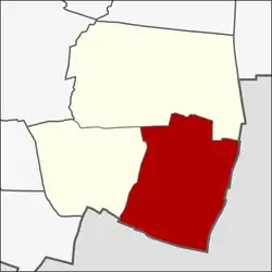 Location in Prawet District | |
| Coordinates: 13°40′04.8″N 100°41′02.8″E | |
| Country | |
| Province | Bangkok |
| Khet | Prawet |
| Area | |
| • Total | 15.172 km2 (5.858 sq mi) |
| Population (2021)[2] | |
| • Total | 53,343 |
| • Density | 3,515.89/km2 (9,106.1/sq mi) |
| Time zone | UTC+7 (ICT) |
| Postal code | 10250 |
| TIS 1099 | 103203 |
Dok Mai is a southeast part of the district. Its name translates to "flower". Neighbouring sub-districts are (from the north clockwise): Prawet in its district (Khlong Makham Thet, Khlong Chorakhe Khop, Khlong Pak Lak, and Khlong Khan Taek are the borderlines), Racha Thewa, Bang Phli Yai in Bang Phli District of Samut Prakan Province (Khlong Khan Taek, Khlong Sing To, Khlong Paknam, and Khlong Salut are the borderlines), Bang Kaeo in Bang Phli District of Samut Prakan Province (farm dike and Khlong Ton Tan are the borderlines), Nong Bon in its district (Khlong Palat Priang is a borderline).
References
- กองยุทธศาสตร์บริหารจัดการ. สำนักยุทธศาสตร์และประเมินผล. กรุงเทพมหานคร. "จำนวนประชากร พื้นที่ ความหนาแน่น จำนวนบ้าน จำแนกตามแขวง ในเขตกรุงเทพมหานคร 2563." สถิติกรุงเทพมหานครประจำปี 2563. Thai: Thai
- กรมการปกครอง. กระทรวงมหาดไทย. "รายงานสถิติจำนวนประชากรและบ้าน ประจำปี พ.ศ. 2564." [ออนไลน์]. เข้าถึงได้จาก: https://stat.bora.dopa.go.th/stat/statnew/statyear/#/TableTemplate4/Area/statpop?yymm=64&ccDesc=กรุงเทพมหานคร&topic=statpop&ccNo=10&rcodeNo=1032&rcodeDesc=เขตประเวศ 2564. Thai: Thai
This article is issued from Wikipedia. The text is licensed under Creative Commons - Attribution - Sharealike. Additional terms may apply for the media files.