Dzūkija
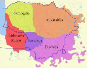
Dzūkija or Dainava is one of five ethnographic regions of Lithuania. Dzūkija is a cultural region defined by traditional lifestyles and dialects of the local Lithuanian population (mostly rural farmers) and has never been defined as a political or administrative unit.[1] Traditionally, Alytus is regarded as the capital of the region and largest city. The region has a significant Polish minority of around one third of the region's total population. Although Vilnius is surrounded by Dzūkija, city itself is not included in any ethnographic region.[2]
Dzūkija
Dainava | |
|---|---|
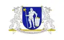 Flag 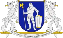 Coat of arms | |
| Motto: Ex gente bellicosissima populus laboriosus | |
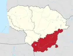 Location of Dzūkija within Lithuania | |
| Country | Lithuania |
| Capital and largest city | Alytus |
| Area | |
| • Total | 12,000 km2 (5,000 sq mi) |
| Population (2021) | |
| • Total | 300,000a |
| Time zone | UTC2 (CET (GMT +2)) |
| a. excluding Vilnius | |
Geography

Dzūkija is situated in southeastern Lithuania, and consists of Alytus County and southern Vilnius County. Historically, it extended into what is now northeastern Poland (Podlaskie Voivodeship) and northwestern Belarus (Grodno Region).
Large parts of Dzūkija have light sandy soil, unsuited for agriculture. Therefore, the region is densely covered with pine forests, one of which is Dainava Forest, the largest in Lithuania. The Čepkeliai Marsh, the largest swamp in Lithuania, is situated in the region, near the border with Belarus. Dzūkija is also the most sparsely populated region in Lithuania, with average population density dropping below 15 people per square kilometer in Varėna district municipality. Due to lower harvests in infertile soil, the region was relatively poorer than the rest of Lithuania. Farmers had to supplement their yields with edible mushrooms and berries collected in the forests. Mushroom hunting remains an important part of the local economy.
Two of the five national parks in Lithuania are to be found in Dzūkija: Dzūkija National Park east of Varėna (established there in 1991), and Trakai National Historic Park near Trakai (1992).
Demographics
The largest settlements (by population) are:
- Alytus – 53,514
- Druskininkai – 13,170
- Elektrėnai – 11,009
- Varėna – 8,021
- Šalčininkai – 6,857
- Nemenčinė – 4,831
- Pabradė – 4,837
- Trakai – 4,141
- Skaidiškės – 4,051
Language
People in Dzūkija traditionally speak the Dzūkian dialect (also known as South Aukštaitian), which is a sub-dialect of the Aukštaitian dialect. As elsewhere in Lithuania, local dialects such as these are dying out in bigger as people adopt the standard Lithuanian through schools and mass media, but still used by older generation in smaller villages like Marcinkonys, Zervynos and others.
The very first Lithuanian handwritten texts from the early 16th century show traits of the Dzūkian dialect.
The north-eastern half speaks Polish and spoke Belarusian for several centuries.
Coat of arms
The coat of arms of Dzūkija pictures a white armored warrior with a pollaxe in a blue shield. The blue color symbolizes loyalty and strength.[3] The grand coat of arms is supported by two lynxes and has a Latin motto Ex gente bellicosissima populus laboriosus (Out of most warring tribe – industrious people). These symbols were created by heraldic artist Arvydas Každailis in 2003 using the historical symbols of Trakai.[3] Dzūkija was part of the Duchy of Trakai and later Trakai Voivodeship from the 14th to late 18th century. The same image was used for the coat of arms of Alytus County, officially adopted in 2004.[3] The coat of arms is a modified version of the coat of arms of Trakai district, which depicts a knight with a spear in a red shield. This symbol was taken from a seal used by Duke of Trakai Kęstutis (died in 1382).[3] The motto honors the memory of the Yotvingians, one of the ancient Baltic tribes which were considered fine warriors that lived in what is now Dzūkija.
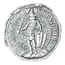 Seal of Duke Kęstutis from 1379.
.jpg.webp) Coat of arms of Duchy of Trakai on the lower left corner of seal of Vytautas the Great, 1404.
Coat of arms of Duchy of Trakai on the lower left corner of seal of Vytautas the Great, 1404..jpg.webp) Coat of arms of Duchy of Trakai on the lower right corner of seal of Vytautas, 1407.
Coat of arms of Duchy of Trakai on the lower right corner of seal of Vytautas, 1407. Coat of arms of Trakai Voivodeship from around the 15th century.
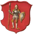 Coat of arms of Trakai Voivodeship from around the 16th century.
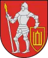 Coat of arms of Trakai District Municipality.
 Coat of arms of Alytus County.
References
- "Alytus – Dzūkijos (Dainavos) regiono sostinė" (in Lithuanian). Alytus city municipality. Archived from the original on 22 July 2011. Retrieved 21 April 2010.
- Lietuvos etnografinių regionų žemėlapis
- Rimša, Edmundas (2004). Lietuvos heraldika II (in Lithuanian). Baltos lankos. pp. 17–19. ISBN 9955-584-69-6.