Earl's Sluice
Earl's Sluice is an underground river in south-east London, England. Its source is Ruskin Park on Denmark Hill. In South Bermondsey it is joined by the River Peck before emptying into the Thames at Deptford Wharf.
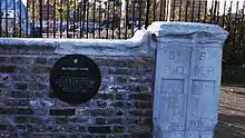
This stone marks the boundary between St Mary's parish, Rotherhithe and St Paul's parish, Deptford. The stone was on a bridge over the Earl Creek nearby, but was relocated to its present position (on the Thames Path between the confluence of the Sluce and the entrance to South Dock, Rotherhithe in 1988.
| Earl's Sluice | |
|---|---|
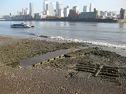 The culverted mouth of the Earl's Sluice at Deptford Wharf | |
| Location | |
| Country | England |
| Counties | Greater London |
| Towns | Deptford |
| Physical characteristics | |
| Source | Ruskin Park |
| • location | Denmark Hill |
| • coordinates | 51°28′0″N 0°5′33″W |
| Mouth | River Thames |
• location | Deptford Wharf |
• coordinates | 51°29′35.19″N 0°1′55.26″W |
| Basin features | |
| Tributaries | |
| • right | River Peck |
Earl's Creek marks the boundary between St Mary's parish, Rotherhithe and St Paul's parish, Deptford and their successors the London Borough of Southwark and the London Borough of Lewisham. It also marks the boundary between the historic counties of Kent and Surrey.[1] The river is named after the Earl of Gloucester in the time of Henry I.
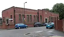
Earl Pumping Station: although closed for years, it processed the water from the Earl's Sluice to the Thames.
References
Further reading
- London's Lost Rivers by Paul Talling
External links
- Earl's Sluice on Diamond Geezer blog.
- Dividing Rotherhithe from Deptford in the mid 1850s: Earl's Sluice, or the Black Ditch
This article is issued from Wikipedia. The text is licensed under Creative Commons - Attribution - Sharealike. Additional terms may apply for the media files.