East Central Texas forests
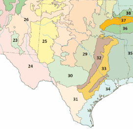
The East Central Texas forests or East Central Texas Plains (33) is a small temperate broadleaf and mixed forests ecoregion almost entirely within the state of Texas, United States.[1] The northern forests perimeter is partially within the southeast Oklahoma border.
| East Central Texas forests | |
|---|---|
.jpg.webp) Northern Post Oak savanna, Gus Engeling Wildlife Management Area | |
 East Central Texas forests (33) | |
| Ecology | |
| Realm | Nearctic |
| Biome | Temperate broadleaf and mixed forests |
| Geography | |
| Area | 52,600 km2 (20,300 sq mi) |
| Country | United States |
| States |
|
| Conservation | |
| Conservation status | Critical/endangered |
| Habitat loss | 75% |

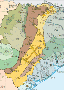
Northern Post Oak Savanna 33a
Southern Post Oak Savanna 33b
San Antonio Prairie 33c
Northern Prairie Outliers 33d
Bastrop Lost Pines 33e
Floodplains and Low Terraces 33f
Description
East Central Texas forests are distinguished from the adjacent Texas blackland prairies and Western Gulf coastal grasslands by their greater tree density. On the other hand, they are more open and have a greater concentration of hardwoods than the forests of the Piney Woods.[1] The climate is hot and humid.[2]
Subregions
Northern Post Oak Savanna
The landscapes of this ecoregion are generally more level and gently rolling compared to the more dissected and irregular topography of much of Southern Post Oak Savanna. It is underlain by mostly Eocene and Paleocene-age formations with some Cretaceous rocks to the north. The deciduous forest or woodland is composed mostly of post oak, blackjack oak, eastern red cedar, and black hickory. Prairie openings contained little bluestem and other grasses and forbs. The land cover currently has more improved pasture and less post oak woods and forest than the Southern Post Oak Savanna. Some coniferous trees occur, especially on the transitional boundary with the Tertiary Uplands ecoregion. Loblolly pine has been planted in several areas. Typical wildlife species include white-tailed deer, eastern wild turkey, northern bobwhite, eastern fox squirrel, and eastern gray squirrel.[3]
Southern Post Oak Savanna
This ecoregion has more woods and forest than the adjacent prairie ecoregions, and consists of mostly hardwoods compared to the pines to the east in the South Central Plains. Historically a post oak savanna, current land cover is a mix of post oak woods, improved pasture, and rangeland, with some invasive mesquite to the south. A thick understory of yaupon and eastern redcedar occurs in some parts. The ecoregion is underlain by Miocene, Oligocene, Eocene, and Paleocene sediments. Sand exposures within these Tertiary deposits have a distinctive sandyland flora, and in a few areas unique bogs occur. The endangered Houston Toad is associated with the deep sandy soils of this ecoregion[3]
San Antonio Prairie
This ecoregion is a narrow, 100-mile long region occurring primarily on the Eocene Cook Mountain Formation. Upland Alfisol prairies were dominated by little bluestem and yellow indiangrass and contained a different mix of grasses and forbs than the dark, clayey, more calcareous soils of the Northern Texas blackland prairies. Since the 1830s, settlement clustered along the Old San Antonio Road (Texas State Highway 21 in the south, Old San Antonio Road in the north) within this narrow belt of prairie land. Currently, land cover is a mosaic of woodland, improved pasture, rangeland, and some cropland.[3]
Northern Prairie Outliers
The small, disjunct areas of this ecoregion have a blend of characteristics from the Texas blackland prairies and the East Central Texas forests. The northern two outliers, north of the Sulphur River, occur on Cretaceous sediments, while south of the river, Paleocene and Eocene formations predominate. A mosaic of forest and prairie occurred historically in this and adjacent regions. Burning was important in maintaining grassy openings, and woody invasions have taken place in the absence of fire. The tallgrass prairies included little bluestem, big bluestem, yellow indiangrass, and tall dropseed. Current land cover is mostly pasture, with some cropland.[3]
Bastrop Lost Pines
1.jpg.webp)
This ecoregion is an outlier of relict loblolly pine-post oak upland forest occurring on some dissected hills. It is the westernmost tract of southern pine in the United States. The pines mostly occur on gravelly soils that formed in Pleistocene high gravel, fluvial terrace deposits associated with the ancestral Colorado River, and sandy soils that formed in Eocene sandstones (such as the Weches Formation). The Lost Pines are about 100 miles (160 km) west of the Texas pine belt of the South Central Plains and occur in a drier environment with 36 inches (910 mm) of average annual precipitation. In this area, the deep, acidic, sandy soils and the additional moisture provided by the Colorado River contribute to the occurrence of pines, which are thought to be a relict population predating the last glacial period. The largest population of the Houston Toad occurs in this ecoregion[3]
Floodplains and Low Terraces
This ecoregion contains floodplain and low terrace deposits downstream from the Texas blackland prairies and upstream from the Texas coastal plains. It includes only the wider floodplains of major streams, such as the Sulphur, Trinity, Brazos, and Colorado rivers. In addition, it covers primarily Holocene deposits and not Pleistocene deposits on older, high terraces. The bottomland forests contain water oak, post oak, elms, green ash, pecan, willow oak to the east, and to the west some hackberry and eastern cottonwoods. The northern floodplains tend to have more forested land cover, while in the south the Brazos and Colorado River floodplains are characterized by more cropland and pasture.[3]
Fauna
The forests are home to a rich wildlife including Virginia opossums (Didelphis virginiana), North American least shrews (Cryptotis parva), North American beavers (Castor canadensis) and many species of butterflies and reptiles. Larger mammals that once lived here, including jaguar (Panthera onca) and Plains bison (Bison bison bison), have now disappeared from the region.[1] Endangered fauna found in this ecoregion include the Houston toad (Bufo houstonensis) and Attwater's prairie chickens (Tympanuchus cupido attwateri).[2]
Conservation
This environment has been heavily altered by cattle ranching and clearance for farmland with only a quarter of the original habitats remaining, in fragmented patches and not in large blocks. There are no national forests in the region.
Gallery
_and_wildflowers%252C_Nockenut_Road%252C_Guadalupe_County%252C_Texas%252C_USA_(6_October_2018).jpg.webp) Oaks trees (Quercus) and wildflowers, Guadalupe County (October 2018).
Oaks trees (Quercus) and wildflowers, Guadalupe County (October 2018)..jpg.webp) Southern Post Oak Savannah habitat, Austin County, (March 2014).
Southern Post Oak Savannah habitat, Austin County, (March 2014)._Kuykend_Road%252C_Austin_County%252C_Texas%252C_USA_(30_January_2014).jpg.webp) Wild Turkey (Meleagris gallopavo), Austin County (January 2014).
Wild Turkey (Meleagris gallopavo), Austin County (January 2014).%252C_Colorado_County%252C_Texas%252C_USA_(30_January_2014).jpg.webp) Southern Post Oak Savannah, Colorado County (January 2014).
Southern Post Oak Savannah, Colorado County (January 2014).%252C_Colorado_County%252C_Texas%252C_USA_(30_January_2014).jpg.webp) Southern Post Oak Savannah, Colorado County, (January 2014).
Southern Post Oak Savannah, Colorado County, (January 2014)._basking_on_a_fencepost%252C_Highway_102%252C_Colorado_County%252C_Texas%252C_USA_(26_March_2017).jpg.webp) Texas spiny lizard (Sceloporus olivaceus) on a fencepost, Colorado County, (March 2017).
Texas spiny lizard (Sceloporus olivaceus) on a fencepost, Colorado County, (March 2017)..jpg.webp) Lake Somerville State Park. Lee County, (May 2017).
Lake Somerville State Park. Lee County, (May 2017)..jpg.webp) Lake Somerville State Park, Lee County (May 2017).
Lake Somerville State Park, Lee County (May 2017)..jpg.webp) Lake Somerville State Park, Lee County (May 2019).
Lake Somerville State Park, Lee County (May 2019)..jpg.webp) Nails Creek, Somerville Public Hunting Lands, Lee County (April 2017).
Nails Creek, Somerville Public Hunting Lands, Lee County (April 2017).%252C_male_right%252C_female_left%252C_Colorado_County%252C_Texas%252C_USA_(17_March_2017).jpg.webp) Northern Bobwhite (Colinus virginianus), male right, female left, Colorado County (March 2017).
Northern Bobwhite (Colinus virginianus), male right, female left, Colorado County (March 2017)..jpg.webp) Northern Post Oak Savanna, Gus Engeling Wildlife Management Area, Anderson County (April 2017).
Northern Post Oak Savanna, Gus Engeling Wildlife Management Area, Anderson County (April 2017)..jpg.webp) Northern Post Oak Savanna, Gus Engeling Wildlife Management Area, Anderson County (April 2017).
Northern Post Oak Savanna, Gus Engeling Wildlife Management Area, Anderson County (April 2017)..jpg.webp) Little Bear Creek, Hays County (October 2010).
Little Bear Creek, Hays County (October 2010)._activity%252C_private_land%252C_Madison_County%252C_Texas%252C_USA._(12_March_2010).jpg.webp) Signs of beaver (Castor canadensis) activity, gnawed tree trunk and burrowing in stream bank. Madison County (March 2010).
Signs of beaver (Castor canadensis) activity, gnawed tree trunk and burrowing in stream bank. Madison County (March 2010).
References
- "East Central Texas forests". Terrestrial Ecoregions. World Wildlife Fund. Retrieved 2010-10-20.
- World Wildlife Fund, ed. (2001). "East Central Texas forests". WildWorld Ecoregion Profile. National Geographic Society. Archived from the original on 2010-03-08. Retrieved 2010-10-20.
-
 This article incorporates public domain material from Ecoregions of Texas poster, back (PDF). United States Geological Survey. Retrieved 2016-02-06.