East Huntingdon Township, Westmoreland County, Pennsylvania
East Huntingdon Township is a township in Westmoreland County, Pennsylvania, United States. The population was 7,712 at the 2020 census.[2] From 1978 to 1988, the township had been home to the Volkswagen Westmoreland Assembly Plant, which later became a Sony plant.[3] As of 2020 companies there include DNP, Cenveo, and Siemens.
East Huntingdon Township, Pennsylvania | |
|---|---|
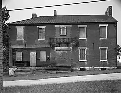
 The former Christian S. Overholt Store in West Overton | |
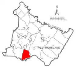
 Map of Westmoreland County, Pennsylvania Highlighting East Huntingdon Township | |
 Map of Pennsylvania highlighting Westmoreland County | |
| Country | United States |
| State | Pennsylvania |
| County | Westmoreland |
| Settled | 1790 |
| Incorporated | 1798 |
| Area | |
| • Total | 32.96 sq mi (85.37 km2) |
| • Land | 32.95 sq mi (85.35 km2) |
| • Water | 0.01 sq mi (0.02 km2) |
| Population | |
| • Total | 7,712 |
| • Estimate (2021)[2] | 7,650 |
| • Density | 234.14/sq mi (90.40/km2) |
| Time zone | UTC-5 (Eastern (EST)) |
| • Summer (DST) | UTC-4 (EDT) |
| FIPS code | 42-129-21304 |
History
The East Huntingdon official website contains a history of the township.
The West Overton Historic District was listed on the National Register of Historic Places in 1985.[4]
The township was the site of the Morewood Massacre of 1891, which occurred during a labor union protest.
Geography
According to the United States Census Bureau, the township has a total area of 32.8 square miles (85 km2), of which 32.8 square miles (85 km2) is land and 0.03% is water. It includes the communities of West Overton, Ruffs Dale, Central, Tars, Rocktown, Feree, West Bethany, Lauffer, Donnelly, Morewood, Reagantown, Alverton, Mayfield, Bessemer, Buckeye, Green Lick, Iron Bridge, Pinetree and Chaintown. [5][6] To the north is New Stanton Borough; to the south is Scottdale and Fayette County.
Demographics
| Census | Pop. | Note | %± |
|---|---|---|---|
| 2000 | 7,781 | — | |
| 2010 | 7,963 | 2.3% | |
| 2020 | 7,712 | −3.2% | |
| 2021 (est.) | 7,650 | [2] | −0.8% |
| U.S. Decennial Census[7] | |||
At the 2000 census there were 7,781 people, 3,142 households, and 2,271 families living in the township. The population density was 237.3 inhabitants per square mile (91.6/km2). There were 3,289 housing units at an average density of 100.3 per square mile (38.7/km2). The racial makeup of the township was 98.68% White, 0.48% African American, 0.09% Native American, 0.22% Asian, 0.03% Pacific Islander, 0.13% from other races, and 0.39% from two or more races. Hispanic or Latino of any race were 0.30%.[8]
Of the 3,142 households 30.0% had children under the age of 18 living with them, 57.7% were married couples living together, 10.5% had a female householder with no husband present, and 27.7% were non-families. 24.3% of households were one person and 11.4% were one person aged 65 or older. The average household size was 2.46 and the average family size was 2.92.
The age distribution was 22.5% under the age of 18, 6.9% from 18 to 24, 29.3% from 25 to 44, 24.3% from 45 to 64, and 17.0% 65 or older. The median age was 40 years. For every 100 females, there were 92.4 males. For every 100 females age 18 and over, there were 90.8 males.
The median household income was $32,460 and the median family income was $39,927. Males had a median income of $29,835 versus $22,787 for females. The per capita income for the township was $15,598. About 9.0% of families and 10.6% of the population were below the poverty line, including 15.1% of those under age 18 and 8.7% of those age 65 or over.
See also
References
- "2016 U.S. Gazetteer Files". United States Census Bureau. Retrieved Aug 14, 2017.
- Bureau, US Census. "City and Town Population Totals: 2020—2021". Census.gov. US Census Bureau. Retrieved July 26, 2022.
- "Former Sony Corp. plant near New Stanton auditions for new tenant". Pittsburgh Tribune-Review, Joe Napsha, June 23, 2010. Archived from the original on June 27, 2010. Retrieved May 31, 2011.
- "National Register Information System". National Register of Historic Places. National Park Service. July 9, 2010.
- "East Huntingdon Second Class Township Map" (PDF). Pennsylvania Department of Transportation. Retrieved 14 February 2022.
- Eidemiller, Maryanne Gogniat (January 17, 2022). "Book author to speak at Magnificat Breakfast Jan. 29". The Latrobe Bulletin. Retrieved 14 February 2022.
- "Census of Population and Housing". Census.gov. Retrieved June 4, 2016.
- "U.S. Census website". United States Census Bureau. Retrieved 2008-01-31.
